TopoQuest Logo
Do you find TopoQuest useful?
Help keep TopoQuest running and adding new maps/features by donating!
Bitcoin:  19c7KJd3qBynnjoSw5npx9KScwjBe4ifkT
Litecoin:  LXs6TkuXGGXo1vDsWCkWVdjQX94eUKd6ui
Home View Maps Find Maps Find Places Resources & Links


Waterboro, Maine Topographic Map

USGS Map Title: Waterboro, ME
USGS Map MRC: 43070E6
DRG (GeoTIFF) Download: o43070e6.tif


Neighboring USGS Topographic Map Quads:


  Limerick, ME  
43070F7
 

  Limington, ME  
43070F6
 

  Standish, ME  
43070F5
 

  Mousam Lake, ME  
43070E7
 

  Waterboro, ME  
43070E6
 

  Bar Mills, ME  
43070E5
 

  Sanford, ME  
43070D7
 

  Alfred, ME  
43070D6
 

  Kennebunk, ME  
43070D5


Map MRC Location:

N44°
W71°
N44°
W70°
H8 H7 H6 H5 H4 H3 H2 H1
G8 G7 G6 G5 G4 G3 G2 G1
F8 F7 F6 F5 F4 F3 F2 F1
E8 E7 E6 E5 E4 E3 E2 E1
D8 D7 D6 D5 D4 D3 D2 D1
C8 C7 C6 C5 C4 C3 C2 C1
B8 B7 B6 B5 B4 B3 B2 B1
A8 A7 A6 A5 A4 A3 A2 A1
N43°
W71°
N43°
W70°

Waterboro, ME USGS 1:24K Topographic Map Preview:
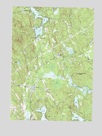
Waterboro, ME USGS Topographic Map
Click on map above to begin viewing in our Map Viewer.

This topographic map contains these locations and features:
Feature Name Type Latitude Longitude GNIS ID View Map
Bartlett BrookStreamN43.5695°W70.6553°561660View Map
Bartlett PondLakeN43.5754°W70.6575°561675View Map
Bunganut PondLakeN43.5071°W70.6998°563175View Map
Calvary ChurchChurchN43.5195°W70.7181°1910794View Map
Carll BranchStreamN43.5206°W70.7228°563558View Map
Chadbourne CemeteryCemeteryN43.5201°W70.6826°563784View Map
Cluff CemeteryCemeteryN43.6115°W70.7173°2737140View Map
Colcord Smith Chadbourne CemeteryCemeteryN43.5395°W70.7332°2737143View Map
Community CemeteryCemeteryN43.5698°W70.6327°2737148View Map
Community ChurchChurchN43.6204°W70.7337°1910826View Map
Cyrus King Hamilton CemeteryCemeteryN43.5789°W70.6738°2736405View Map
David Jellerson CemeteryCemeteryN43.5702°W70.6599°2736406View Map
Day LotCemeteryN43.5778°W70.6469°2736412View Map
Deering RidgeRidgeN43.6004°W70.6678°565012View Map
Dominicus Warren CemeteryCemeteryN43.5927°W70.6925°2736421View Map
East WaterboroPopulated PlaceN43.5715°W70.6789°565700View Map
East Waterboro Post OfficePost OfficeN43.5706°W70.6754°2768971View Map
East Waterboro Village CemeteryCemeteryN43.5716°W70.6766°2736427View Map
Flood CemeteryCemeteryN43.6209°W70.7042°2736870View Map
Free Baptist ChurchChurchN43.5720°W70.6784°1910898View Map
Gardner CemeteryCemeteryN43.5961°W70.7283°2736881View Map
George Hall CemeteryCemeteryN43.5369°W70.7175°2736887View Map
Gile CemeteryCemeteryN43.5356°W70.7496°2736889View Map
Grant HillSummitN43.5152°W70.6564°567058View Map
Grant LotCemeteryN43.5123°W70.6519°2736901View Map
Hamilton CemeteryCemeteryN43.5473°W70.7106°2736455View Map
Hamlinton BrookStreamN43.5206°W70.7228°567537View Map
Hobbs CemeteryCemeteryN43.5794°W70.7435°2736467View Map
Jones CemeteryCemeteryN43.6150°W70.7204°2736484View Map
Kennebunk PondLakeN43.5040°W70.6474°569114View Map
Little Ossipee Lake Seaplane BaseAirportN43.6131°W70.6959°582243View Map
Little Ossipee PondLakeN43.5980°W70.7090°569945View Map
Maine State Police Troop ABuildingN43.5115°W70.7176°2735975View Map
Massabesic Adult Education CenterSchoolN43.5355°W70.7214°2738106View Map
Massabesic High SchoolSchoolN43.5367°W70.7244°1911016View Map
Massabesic Middle SchoolSchoolN43.5807°W70.7006°1911017View Map
McLucas CemeteryCemeteryN43.5959°W70.7286°2736539View Map
Moody PondLakeN43.5625°W70.7387°571550View Map
North WaterboroPopulated PlaceN43.6204°W70.7353°572425View Map
North Waterboro Post OfficePost OfficeN43.6212°W70.7351°1911056View Map
Notre Dame InstituteSchoolN43.5009°W70.7153°572526View Map
Ossipee HillSummitN43.5885°W70.7405°572789View Map
Ossipee Hill TrailTrailN43.5965°W70.7398°1911089View Map
Pine Grove CemeteryCemeteryN43.5380°W70.7247°2737201View Map
Ricker CemeteryCemeteryN43.5345°W70.6952°2737221View Map
Ricker HillSummitN43.5348°W70.6937°574187View Map
Roberts CemeteryCemeteryN43.5165°W70.7479°2737229View Map
Roberts PondLakeN43.5351°W70.6439°574303View Map
Roberts RidgeRidgeN43.5870°W70.6864°574305View Map
Saint Stephen the Martyr MissionChurchN43.5923°W70.7109°1911147View Map
Scotts Cove Camping AreaLocaleN43.5123°W70.7101°1911165View Map
Scribner CemeteryCemeteryN43.5257°W70.7303°2737247View Map
Shaker BrookStreamN43.5029°W70.7228°575291View Map
Smith Coffin CemeteryCemeteryN43.5414°W70.7444°2737263View Map
South HollisPopulated PlaceN43.5698°W70.6328°579717View Map
Swan PondLakeN43.5207°W70.6493°576579View Map
Tarwater PondLakeN43.5476°W70.6744°576665View Map
The HeathSwampN43.5479°W70.6845°576816View Map
Town of LymanCivilN43.5025°W70.6436°582572View Map
Town of WaterboroCivilN43.5972°W70.7303°582793View Map
WaterboroPopulated PlaceN43.5356°W70.7151°577885View Map
Waterboro CenterPopulated PlaceN43.5892°W70.7098°577886View Map
Waterboro Elementary SchoolSchoolN43.5862°W70.7060°1911239View Map
Waterboro Fire and Emergency Medical ServicesBuildingN43.5874°W70.7079°2552751View Map
Waterboro Fire Department North Station (historical)BuildingN43.6202°W70.7346°2553150View Map
Waterboro Fire Department South StationBuildingN43.5341°W70.7154°2553074View Map
Waterboro Old Corner ChurchChurchN43.5381°W70.7353°1911240View Map
Waterboro Post OfficePost OfficeN43.5321°W70.7187°1911241View Map
Waterboro Public LibraryBuildingN43.5714°W70.6764°2738442View Map
West OutletStreamN43.5026°W70.6701°578182View Map
Weymouth CemeteryCemeteryN43.5819°W70.6501°2736585View Map
York County SheltersBuildingN43.5015°W70.7153°2655130View Map

Note: Coordinates in the location and feature list above are referenced to NAD83 datum.


Copyright (C) 2008-2024 Ryan Niemi / Sunset Dynamics ... All Rights Reserved