TopoQuest Logo
Do you find TopoQuest useful?
Help keep TopoQuest running and adding new maps/features by donating!
Bitcoin:  19c7KJd3qBynnjoSw5npx9KScwjBe4ifkT
Litecoin:  LXs6TkuXGGXo1vDsWCkWVdjQX94eUKd6ui
Home View Maps Find Maps Find Places Resources & Links


Limington, Maine Topographic Map

USGS Map Title: Limington, ME
USGS Map MRC: 43070F6
DRG (GeoTIFF) Download: o43070f6.tif


Neighboring USGS Topographic Map Quads:


  Cornish, ME  
43070G7
 

  Steep Falls, ME  
43070G6
 

  Sebago Lake, ME  
43070G5
 

  Limerick, ME  
43070F7
 

  Limington, ME  
43070F6
 

  Standish, ME  
43070F5
 

  Mousam Lake, ME  
43070E7
 

  Waterboro, ME  
43070E6
 

  Bar Mills, ME  
43070E5


Map MRC Location:

N44°
W71°
N44°
W70°
H8 H7 H6 H5 H4 H3 H2 H1
G8 G7 G6 G5 G4 G3 G2 G1
F8 F7 F6 F5 F4 F3 F2 F1
E8 E7 E6 E5 E4 E3 E2 E1
D8 D7 D6 D5 D4 D3 D2 D1
C8 C7 C6 C5 C4 C3 C2 C1
B8 B7 B6 B5 B4 B3 B2 B1
A8 A7 A6 A5 A4 A3 A2 A1
N43°
W71°
N43°
W70°

Limington, ME USGS 1:24K Topographic Map Preview:
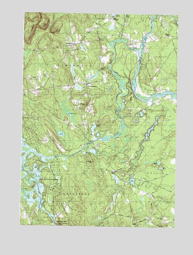
Limington, ME USGS Topographic Map
Click on map above to begin viewing in our Map Viewer.

This topographic map contains these locations and features:
Feature Name Type Latitude Longitude GNIS ID View Map
Black BrookStreamN43.7190°W70.6806°562386View Map
Boulter John CemeteryCemeteryN43.7080°W70.6446°2736127View Map
Boyd PondLakeN43.6823°W70.6921°562821View Map
Brackett LotCemeteryN43.6750°W70.7305°2737099View Map
Brown BrookStreamN43.6704°W70.7426°563034View Map
Carpenter Number 1 CemeteryCemeteryN43.6350°W70.7469°2737121View Map
Chadbournes MillsPopulated PlaceN43.6265°W70.7217°578941View Map
Chadbournes RidgeRidgeN43.6335°W70.7132°578933View Map
Davis Memorial LibraryBuildingN43.7314°W70.7097°1910834View Map
Deer PondLakeN43.6519°W70.6598°564999View Map
Doles PondLakeN43.6790°W70.7181°565182View Map
Dominicus Hasty LotCemeteryN43.6743°W70.7286°2736420View Map
Earl Gerry Whitehouse CemeteryCemeteryN43.6569°W70.6978°2736425View Map
East LimingtonPopulated PlaceN43.7340°W70.6578°565630View Map
Edgecomb BridgeBridgeN43.6736°W70.6953°565786View Map
Elder Grey CemeteryCemeteryN43.6358°W70.7131°2736429View Map
Emerson SchoolSchoolN43.7070°W70.7242°565899View Map
Foss PondsLakeN43.6897°W70.7103°566445View Map
H B Emery Jr Memorial SchoolSchoolN43.7287°W70.7094°1910919View Map
Hamlin BrookStreamN43.7354°W70.6723°567533View Map
Higgins CornerPopulated PlaceN43.7376°W70.6339°579404View Map
Hollis Fire Department Station 2 and Main OfficeBuildingN43.6564°W70.6294°2553083View Map
Horse Pond BrookStreamN43.7459°W70.6689°1912574View Map
Isinglass HillSummitN43.6630°W70.6926°568688View Map
Isinglass PondLakeN43.6692°W70.6922°568689View Map
Killick PondLakeN43.6816°W70.6462°569163View Map
Kinrick Hanson LotCemeteryN43.6263°W70.6384°2736497View Map
Lake ArrowheadReservoirN43.6394°W70.7430°576798View Map
Lake ArrowheadPopulated PlaceN43.6637°W70.7348°1852247View Map
Lake Arrowhead Census Designated PlaceCensusN43.6634°W70.7382°2377924View Map
Lake Arrowhead EstatesPopulated PlaceN43.6529°W70.7189°1910982View Map
Ledgemere DamDamN43.6651°W70.7226°1773585View Map
Libby MountainSummitN43.7395°W70.7250°569536View Map
Lily PondLakeN43.6600°W70.6369°569566View Map
LimingtonPopulated PlaceN43.7317°W70.7109°569594View Map
Limington AcademySchoolN43.7298°W70.7092°1910991View Map
Limington Congregation ChurchChurchN43.7320°W70.7081°1910992View Map
Limington Fire and Emergency Medical ServicesBuildingN43.7416°W70.6899°2552951View Map
Limington Post OfficePost OfficeN43.7477°W70.6801°1910993View Map
Limington Volunteer Fire Department Station 2BuildingN43.6648°W70.6817°2552966View Map
Little Ossipee PondReservoirN43.6264°W70.7218°1774080View Map
Little Ossipee Pond DamDamN43.6264°W70.7218°1774079View Map
Little Ossipee RiverStreamN43.7290°W70.6589°569946View Map
Maloy MountainSummitN43.6966°W70.6987°570690View Map
North HollisPopulated PlaceN43.6573°W70.6751°572349View Map
North LimingtonPopulated PlaceN43.7473°W70.6817°572358View Map
North Limington DamDamN43.7488°W70.6774°1774177View Map
Pleasant Hill Baptist ChurchChurchN43.6270°W70.6553°1911103View Map
Pleasant Hill ChurchChurchN43.6262°W70.6381°1911104View Map
Salmon Falls SchoolSchoolN43.6301°W70.6351°1911151View Map
Sand PondLakeN43.6916°W70.6535°574852View Map
South LimingtonPopulated PlaceN43.7087°W70.6995°575864View Map
South Limington Number 2 CemeteryCemeteryN43.7069°W70.7227°2737266View Map
Swetts MeadowSwampN43.7295°W70.7009°576615View Map
The Flowage ReservoirReservoirN43.6651°W70.7228°1773586View Map
Town of LimingtonCivilN43.7356°W70.7026°582558View Map
Wales PondLakeN43.6628°W70.6383°577785View Map
Watchic Pond DamDamN43.7463°W70.6261°1773593View Map
West HollisPopulated PlaceN43.6262°W70.6564°578158View Map
Whittier SchoolSchoolN43.6901°W70.6989°578442View Map
York CemeteryCemeteryN43.7064°W70.6570°2736268View Map

Note: Coordinates in the location and feature list above are referenced to NAD83 datum.


Copyright (C) 2008-2024 Ryan Niemi / Sunset Dynamics ... All Rights Reserved