TopoQuest Logo
Do you find TopoQuest useful?
Help keep TopoQuest running and adding new maps/features by donating!
Bitcoin:  19c7KJd3qBynnjoSw5npx9KScwjBe4ifkT
Litecoin:  LXs6TkuXGGXo1vDsWCkWVdjQX94eUKd6ui
Home View Maps Find Maps Find Places Resources & Links


Watson, Arkansas Topographic Map

USGS Map Title: Watson, AR
USGS Map MRC: 33091H3
DRG (GeoTIFF) Download: o33091h3.tif


Neighboring USGS Topographic Map Quads:


  Gillett, AR  
34091A4
 

  Arkansas Post, AR  
34091A3
 

  Henrico SW, AR  
34091A2
 

  Dumas, AR  
33091H4
 

  Watson, AR  
33091H3
 

  Yancopin, AR  
33091H2
 

  Winchester, AR  
33091G4
 

  Kelso, AR  
33091G3
 

  Lake Cheatham, AR  
33091G2


Map MRC Location:

N34°
W92°
N34°
W91°
H8 H7 H6 H5 H4 H3 H2 H1
G8 G7 G6 G5 G4 G3 G2 G1
F8 F7 F6 F5 F4 F3 F2 F1
E8 E7 E6 E5 E4 E3 E2 E1
D8 D7 D6 D5 D4 D3 D2 D1
C8 C7 C6 C5 C4 C3 C2 C1
B8 B7 B6 B5 B4 B3 B2 B1
A8 A7 A6 A5 A4 A3 A2 A1
N33°
W92°
N33°
W91°

Watson, AR USGS 1:24K Topographic Map Preview:
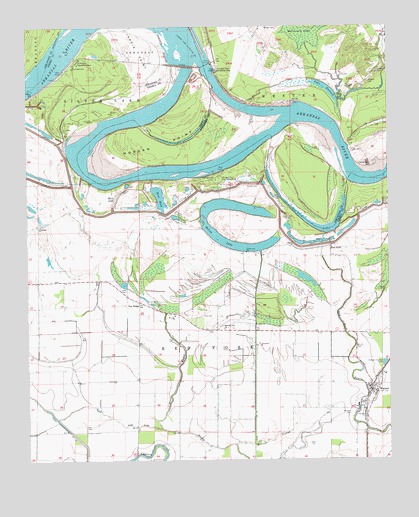
Watson, AR USGS Topographic Map
Click on map above to begin viewing in our Map Viewer.

This topographic map contains these locations and features:
Feature Name Type Latitude Longitude GNIS ID View Map
Barnett CemeteryCemeteryN33.9451°W91.2859°46110View Map
Belcoe LakeLakeN33.9365°W91.3014°76290View Map
Blue HoleLakeN33.9509°W91.3293°46749View Map
Choctaw Village (historical)Populated PlaceN33.9986°W91.3316°2487085View Map
City of WatsonCivilN33.8939°W91.2573°2405688View Map
Coose CemeteryCemeteryN33.9868°W91.2534°48019View Map
Dam Number 2DamN33.9888°W91.3129°82010View Map
Davis LakeSwampN33.9522°W91.3429°48394View Map
Dixon BayouStreamN33.8843°W91.3293°48533View Map
Gardener CemeteryCemeteryN33.9901°W91.2512°49336View Map
Gentry CemeteryCemeteryN33.9543°W91.2951°49367View Map
Irby CemeteryCemeteryN33.9168°W91.3148°50517View Map
Jardis PointCapeN33.9937°W91.3360°77367View Map
Jerusalem ChurchChurchN33.9426°W91.3715°50635View Map
Jones CemeteryCemeteryN33.9248°W91.3421°50717View Map
Lake DumondLakeN33.9818°W91.2713°76828View Map
Little Zion ChurchChurchN33.9351°W91.2996°51346View Map
Medford (historical)Populated PlaceN33.9459°W91.3501°63811View Map
Menard CemeteryCemeteryN33.9840°W91.2565°51912View Map
Morgan CemeteryCemeteryN33.8884°W91.2637°52189View Map
Morgan PointCapeN33.9637°W91.3423°52194View Map
Morgan Point Recreation AreaParkN33.9570°W91.3079°77689View Map
Morning Star ChurchChurchN33.9129°W91.3073°52200View Map
Nady ChurchChurchN33.9973°W91.2501°52569View Map
Notrebes Bend Recreation AreaParkN33.9879°W91.3093°77865View Map
Oak Log BayouStreamN33.8795°W91.2971°52938View Map
Osotouy (historical)Populated PlaceN33.9668°W91.2626°62273View Map
Pea RidgePopulated PlaceN33.9207°W91.3368°53239View Map
Pendleton Recreation AreaParkN33.9895°W91.3573°77975View Map
Pool TwoReservoirN33.9890°W91.3132°79588View Map
Porter CemeteryCemeteryN33.9237°W91.2515°53701View Map
Red ForkPopulated PlaceN33.9365°W91.2701°78142View Map
Red Fork LakeLakeN33.9440°W91.2784°77304View Map
Saint John ChurchChurchN33.9168°W91.3246°54352View Map
Township of Red ForkCivilN33.8928°W91.2559°66504View Map
WatsonPopulated PlaceN33.8951°W91.2562°56106View Map
Watson Post OfficePost OfficeN33.8978°W91.2562°2781904View Map
Watson Volunteer Fire Department Station 1BuildingN33.8956°W91.2560°2117280View Map
Watson Volunteer Fire Station 2BuildingN33.8899°W91.2590°2117281View Map
Willow SloughStreamN33.8795°W91.2971°56418View Map

Note: Coordinates in the location and feature list above are referenced to NAD83 datum.


Copyright (C) 2008-2024 Ryan Niemi / Sunset Dynamics ... All Rights Reserved