TopoQuest Logo
Do you find TopoQuest useful?
Help keep TopoQuest running and adding new maps/features by donating!
Bitcoin:  19c7KJd3qBynnjoSw5npx9KScwjBe4ifkT
Litecoin:  LXs6TkuXGGXo1vDsWCkWVdjQX94eUKd6ui
Home View Maps Find Maps Find Places Resources & Links


Yancopin, Arkansas Topographic Map

USGS Map Title: Yancopin, AR
USGS Map MRC: 33091H2
DRG (GeoTIFF) Download: o33091h2.tif


Neighboring USGS Topographic Map Quads:


  Arkansas Post, AR  
34091A3
 

  Henrico SW, AR  
34091A2
 

  Snow Lake, AR  
34091A1
 

  Watson, AR  
33091H3
 

  Yancopin, AR  
33091H2
 

  Montgomery Island, AR  
33091H1
 

  Kelso, AR  
33091G3
 

  Lake Cheatham, AR  
33091G2
 

  Rosedale, MS  
33091G1


Map MRC Location:

N34°
W92°
N34°
W91°
H8 H7 H6 H5 H4 H3 H2 H1
G8 G7 G6 G5 G4 G3 G2 G1
F8 F7 F6 F5 F4 F3 F2 F1
E8 E7 E6 E5 E4 E3 E2 E1
D8 D7 D6 D5 D4 D3 D2 D1
C8 C7 C6 C5 C4 C3 C2 C1
B8 B7 B6 B5 B4 B3 B2 B1
A8 A7 A6 A5 A4 A3 A2 A1
N33°
W92°
N33°
W91°

Yancopin, AR USGS 1:24K Topographic Map Preview:
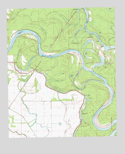
Yancopin, AR USGS Topographic Map
Click on map above to begin viewing in our Map Viewer.

This topographic map contains these locations and features:
Feature Name Type Latitude Longitude GNIS ID View Map
Bear PondLakeN33.9735°W91.1520°76270View Map
BenzalPopulated PlaceN33.9990°W91.1615°57360View Map
Black LakeSwampN33.9748°W91.1439°46672View Map
Bobtail LakeLakeN33.9144°W91.1589°76386View Map
Brushy LakeSwampN33.9368°W91.1895°47086View Map
Canal Number 67CanalN33.8912°W91.2304°81995View Map
Carter BayouGutN33.9182°W91.2282°47488View Map
Carter SloughGutN33.9318°W91.2351°47498View Map
Como ReachChannelN33.9682°W91.2440°62177View Map
Garland LakeSwampN33.9791°W91.2100°49343View Map
Hog Pen HoleLakeN33.9345°W91.1776°77192View Map
Hopedale LandingLocaleN33.9482°W91.2398°63812View Map
House BendBendN33.9587°W91.1718°62224View Map
Jefferson BendBendN33.8848°W91.1476°63814View Map
John Smith LakeLakeN33.9660°W91.1572°77276View Map
La Grues LakeSwampN33.9829°W91.1749°50924View Map
Lacy (historical)Populated PlaceN33.9204°W91.2359°63813View Map
MedinaPopulated PlaceN33.9643°W91.1987°77641View Map
Melinda BarBarN33.9559°W91.1696°51900View Map
Menard BendBendN33.9779°W91.2293°62243View Map
Menard-Hodges SiteParkN33.9889°W91.2153°2489180View Map
Minnie Anderson Old RiverLakeN33.9012°W91.1633°77674View Map
Mixture BayouStreamN33.9704°W91.1251°52112View Map
Mixture LakeLakeN33.9996°W91.1329°77290View Map
Mound LakeLakeN33.9009°W91.2271°77293View Map
Old River LakeLakeN33.9513°W91.1569°77298View Map
Owens LakeLakeN33.9780°W91.1669°77300View Map
Poverty PointCapeN33.9620°W91.1384°53735View Map
Rosemary Lake (historical)LakeN33.9209°W91.1321°63815View Map
Rosemary Landing (historical)LocaleN33.9245°W91.1468°63816View Map
Sandy BayouGutN33.9404°W91.2004°54563View Map
Saw Mill Bend CutoffChannelN33.9365°W91.1498°54599View Map
Skinner LakeSwampN33.9424°W91.1389°54891View Map
Smith LakeLakeN33.8881°W91.1623°77311View Map
Trusten Holder State Wildlife Management AreaParkN33.9918°W91.1946°62321View Map
Turner Cemetery (historical)CemeteryN33.8790°W91.1315°55738View Map
Webfoot LakeLakeN33.9453°W91.1338°77320View Map
YancopinPopulated PlaceN33.9407°W91.2187°57242View Map
Yancopin AirportAirportN33.9512°W91.1749°2650715View Map
Yancopin LakeSwampN33.9214°W91.1913°56580View Map
Yancopin LakeSwampN33.9302°W91.1933°56581View Map

Note: Coordinates in the location and feature list above are referenced to NAD83 datum.


Copyright (C) 2008-2024 Ryan Niemi / Sunset Dynamics ... All Rights Reserved