TopoQuest Logo
Do you find TopoQuest useful?
Help keep TopoQuest running and adding new maps/features by donating!
Bitcoin:  19c7KJd3qBynnjoSw5npx9KScwjBe4ifkT
Litecoin:  LXs6TkuXGGXo1vDsWCkWVdjQX94eUKd6ui
Home View Maps Find Maps Find Places Resources & Links


Kelso, Arkansas Topographic Map

USGS Map Title: Kelso, AR
USGS Map MRC: 33091G3
DRG (GeoTIFF) Download: o33091g3.tif


Neighboring USGS Topographic Map Quads:


  Dumas, AR  
33091H4
 

  Watson, AR  
33091H3
 

  Yancopin, AR  
33091H2
 

  Winchester, AR  
33091G4
 

  Kelso, AR  
33091G3
 

  Lake Cheatham, AR  
33091G2
 

  McGehee North, AR  
33091F4
 

  McArthur, AR  
33091F3
 

  Catfish Point, MS  
33091F2


Map MRC Location:

N34°
W92°
N34°
W91°
H8 H7 H6 H5 H4 H3 H2 H1
G8 G7 G6 G5 G4 G3 G2 G1
F8 F7 F6 F5 F4 F3 F2 F1
E8 E7 E6 E5 E4 E3 E2 E1
D8 D7 D6 D5 D4 D3 D2 D1
C8 C7 C6 C5 C4 C3 C2 C1
B8 B7 B6 B5 B4 B3 B2 B1
A8 A7 A6 A5 A4 A3 A2 A1
N33°
W92°
N33°
W91°

Kelso, AR USGS 1:24K Topographic Map Preview:
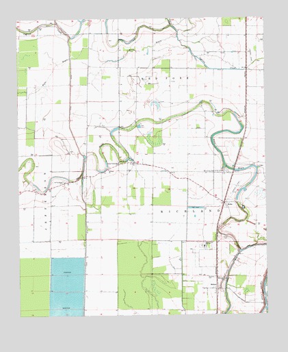
Kelso, AR USGS Topographic Map
Click on map above to begin viewing in our Map Viewer.

This topographic map contains these locations and features:
Feature Name Type Latitude Longitude GNIS ID View Map
Amos Bayou ChurchChurchN33.8154°W91.3198°45856View Map
Delta Elementary SchoolSchoolN33.7789°W91.2818°63830View Map
Delta High SchoolSchoolN33.7787°W91.2818°2039327View Map
Desha Central High SchoolSchoolN33.7790°W91.2815°76787View Map
Desha CountyCivilN33.8333°W91.2539°66850View Map
DucePopulated PlaceN33.7773°W91.2751°63829View Map
KelsoPopulated PlaceN33.7976°W91.2707°50800View Map
Kelso CemeteryCemeteryN33.7829°W91.2701°50801View Map
Kelso Rohwer Fire DepartmentBuildingN33.7963°W91.2711°2116662View Map
Kurdo (historical)Populated PlaceN33.8284°W91.2598°63864View Map
Littles (historical)Populated PlaceN33.8715°W91.2584°63828View Map
Memorial CemeteryCemeteryN33.7662°W91.2801°63831View Map
Oak Grove ChurchChurchN33.7648°W91.2721°52899View Map
Richland Baptist ChurchChurchN33.8115°W91.3296°78173View Map
RohwerPopulated PlaceN33.7609°W91.2757°58514View Map
Rohwer Post OfficePost OfficeN33.7627°W91.2734°2781954View Map
Rohwer Relocation Center CemeteryCemeteryN33.7664°W91.2797°2489245View Map
Rohwer War Relocation Center (historical)LocaleN33.7661°W91.2794°2401189View Map
Rolling Water CemeteryCemeteryN33.8068°W91.3523°54175View Map
Saint Lake ChurchChurchN33.8140°W91.3160°54377View Map
Township of RichlandCivilN33.7788°W91.2781°66505View Map
United Pentecostal ChurchChurchN33.8137°W91.3246°55841View Map
Zellner (historical)Populated PlaceN33.8132°W91.2654°63863View Map

Note: Coordinates in the location and feature list above are referenced to NAD83 datum.


Copyright (C) 2008-2025 Ryan Niemi / Sunset Dynamics ... All Rights Reserved