TopoQuest Logo
Do you find TopoQuest useful?
Help keep TopoQuest running and adding new maps/features by donating!
Bitcoin:  19c7KJd3qBynnjoSw5npx9KScwjBe4ifkT
Litecoin:  LXs6TkuXGGXo1vDsWCkWVdjQX94eUKd6ui
Home View Maps Find Maps Find Places Resources & Links


Watson, Montana Topographic Map

USGS Map Title: Watson, MT
USGS Map MRC: 46111F3
DRG (GeoTIFF) Download: o46111f3.tif


Neighboring USGS Topographic Map Quads:


  Lingshire, MT  
46111G4
 

  Ellis Canyon, MT  
46111G3
 

  Devils Footstool, MT  
46111G2
 

  Whites City, MT  
46111F4
 

  Watson, MT  
46111F3
 

  Fort Logan, MT  
46111F2
 

  Diamond City, MT  
46111E4
 

  Boulder Baldy, MT  
46111E3
 

  Gipsy Lake, MT  
46111E2


Map MRC Location:

N47°
W112°
N47°
W111°
H8 H7 H6 H5 H4 H3 H2 H1
G8 G7 G6 G5 G4 G3 G2 G1
F8 F7 F6 F5 F4 F3 F2 F1
E8 E7 E6 E5 E4 E3 E2 E1
D8 D7 D6 D5 D4 D3 D2 D1
C8 C7 C6 C5 C4 C3 C2 C1
B8 B7 B6 B5 B4 B3 B2 B1
A8 A7 A6 A5 A4 A3 A2 A1
N46°
W112°
N46°
W111°

Watson, MT USGS 1:24K Topographic Map Preview:
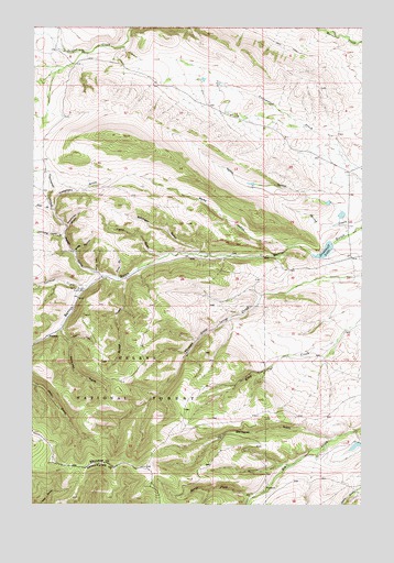
Watson, MT USGS Topographic Map
Click on map above to begin viewing in our Map Viewer.

This topographic map contains these locations and features:
Feature Name Type Latitude Longitude GNIS ID View Map
11N03E28D___01 WellWellN46.6799°W111.3575°817742View Map
Batchelor GulchValleyN46.6911°W111.3119°779433View Map
Beaver Dam GulchValleyN46.6824°W111.3727°779620View Map
Benton Gulch Guard StationLocaleN46.6816°W111.3561°779711View Map
Bridge GulchValleyN46.6836°W111.3397°780401View Map
Calf GulchValleyN46.6855°W111.3505°780780View Map
Camp GulchValleyN46.6905°W111.3258°780856View Map
Cottonwood HollowValleyN46.7019°W111.3675°781737View Map
Deer GulchValleyN46.7022°W111.3675°782255View Map
Democrat GulchValleyN46.6427°W111.2619°782293View Map
Freighters GulchValleyN46.7022°W111.3675°783727View Map
Horse GulchValleyN46.6849°W111.3494°785047View Map
Kentucky GulchValleyN46.6713°W111.3638°785688View Map
Kettle HollowValleyN46.7033°W111.2605°785700View Map
Lambing Camp GulchValleyN46.6949°W111.3638°785937View Map
North Fork Elk CreekStreamN46.6274°W111.2911°788152View Map
PrestonPopulated PlaceN46.7438°W111.3583°794796View Map
Road GulchValleyN46.6849°W111.3430°789619View Map
Robin Hood Number 1 DamDamN46.7049°W111.2625°798351View Map
Robin Hood Number 2 DamDamN46.7016°W111.2591°798352View Map
Rocky HollowValleyN46.6927°W111.2783°789733View Map
Roger Rader DamDamN46.6399°W111.2525°795021View Map
Scarecrow GulchValleyN46.6977°W111.3622°790102View Map
Snag HollowValleyN46.6913°W111.3594°790753View Map
Stoyanoff DamDamN46.6916°W111.2625°795022View Map
Stoyanoff LakeReservoirN46.6916°W111.2647°791579View Map
Thomas Creek MineMineN46.6733°W111.3013°804696View Map
Vermont CreekStreamN46.6822°W111.3547°792697View Map
Vermont Creek MineMineN46.6816°W111.3563°804693View Map
WatsonPopulated PlaceN46.6691°W111.3691°792883View Map
Watson Post Office (historical)Post OfficeN46.6691°W111.3691°1762721View Map
Watson School (historical)SchoolN46.6691°W111.3691°1762728View Map
Wry CreekStreamN46.7438°W111.3636°793965View Map

Note: Coordinates in the location and feature list above are referenced to NAD83 datum.


Copyright (C) 2008-2025 Ryan Niemi / Sunset Dynamics ... All Rights Reserved