TopoQuest Logo
Do you find TopoQuest useful?
Help keep TopoQuest running and adding new maps/features by donating!
Bitcoin:  19c7KJd3qBynnjoSw5npx9KScwjBe4ifkT
Litecoin:  LXs6TkuXGGXo1vDsWCkWVdjQX94eUKd6ui
Home View Maps Find Maps Find Places Resources & Links


Waunakee, Wisconsin Topographic Map

USGS Map Title: Waunakee, WI
USGS Map MRC: 43089B4
DRG (GeoTIFF) Download: o43089b4.tif


Neighboring USGS Topographic Map Quads:


  Lodi, WI  
43089C5
 

  Arlington, WI  
43089C4
 

  Morrisonville, WI  
43089C3
 

  Springfield Corners, WI  
43089B5
 

  Waunakee, WI  
43089B4
 

  De Forest, WI  
43089B3
 

  Middleton, WI  
43089A5
 

  Madison West, WI  
43089A4
 

  Madison East, WI  
43089A3


Map MRC Location:

N44°
W90°
N44°
W89°
H8 H7 H6 H5 H4 H3 H2 H1
G8 G7 G6 G5 G4 G3 G2 G1
F8 F7 F6 F5 F4 F3 F2 F1
E8 E7 E6 E5 E4 E3 E2 E1
D8 D7 D6 D5 D4 D3 D2 D1
C8 C7 C6 C5 C4 C3 C2 C1
B8 B7 B6 B5 B4 B3 B2 B1
A8 A7 A6 A5 A4 A3 A2 A1
N43°
W90°
N43°
W89°

Waunakee, WI USGS 1:24K Topographic Map Preview:
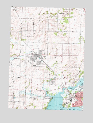
Waunakee, WI USGS Topographic Map
Click on map above to begin viewing in our Map Viewer.

This topographic map contains these locations and features:
Feature Name Type Latitude Longitude GNIS ID View Map
Arboretum Elementary SchoolSchoolN43.1764°W89.4178°2716532View Map
Blackwoods School (historical)SchoolN43.1375°W89.4615°1561905View Map
Camp IndianolaLocaleN43.1303°W89.4340°1562618View Map
Catfish (historical)Populated PlaceN43.1514°W89.4032°1842357View Map
Catfish SchoolSchoolN43.1589°W89.4023°1562806View Map
Centennial ParkParkN43.1833°W89.4676°1842358View Map
Central Wisconsin Center SchoolSchoolN43.1384°W89.3945°1562912View Map
Cherokee LakeLakeN43.1567°W89.3765°1562983View Map
Dane AirportAirportN43.2223°W89.4688°1581938View Map
Dorn CreekStreamN43.1419°W89.4354°1574611View Map
Dorn Creek Marsh State Fishery AreaParkN43.1417°W89.4557°1842386View Map
Endres QuarryMineN43.2056°W89.4408°2633676View Map
Fabrita OrchardLocaleN43.1833°W89.4208°2516922View Map
Farwells PointCapeN43.1311°W89.4096°1564876View Map
First Presbyterian ChurchChurchN43.1905°W89.4565°1842424View Map
Governor Nelson State ParkParkN43.1344°W89.4357°1842440View Map
Heritage Elementary SchoolSchoolN43.1873°W89.4546°1842745View Map
Kingsley CemeteryCemeteryN43.1704°W89.4963°1567511View Map
Kingsley CornersPopulated PlaceN43.1772°W89.4965°1842488View Map
Lakeview Lutheran CemeteryCemeteryN43.1384°W89.3774°2781260View Map
Lindbergh Elementary SchoolSchoolN43.1433°W89.3886°1568131View Map
Madison Country Day SchoolSchoolN43.1624°W89.3876°2716179View Map
Maier FarmsLocaleN43.2450°W89.4381°2704147View Map
Matsen CemeteryCemeteryN43.2427°W89.4017°1569124View Map
MendotaPopulated PlaceN43.1408°W89.3912°1842544View Map
Mendota Elementary SchoolSchoolN43.1367°W89.3835°1569335View Map
Mendota Mental Health InstituteHospitalN43.1325°W89.3985°1569336View Map
Mendota Mental Health Institution SchoolSchoolN43.1332°W89.4021°2716296View Map
Nerdahl ParkParkN43.1322°W89.3890°1842577View Map
Northland Manor ParkParkN43.1472°W89.3815°1842585View Map
Norway GrovePopulated PlaceN43.2486°W89.4026°1577757View Map
Norway Grove SchoolSchoolN43.2430°W89.4146°1570541View Map
Peace Lutheran ChurchChurchN43.1858°W89.4612°1842612View Map
Prairie Elementary SchoolSchoolN43.1987°W89.4530°2716843View Map
Saint John the Baptist Catholic ChurchChurchN43.1900°W89.4548°1842650View Map
Saint John the Baptist SchoolSchoolN43.1893°W89.4535°1842651View Map
Saint John's CemeteryCemeteryN43.1887°W89.4520°2781296View Map
Saint Mary of the Lake Catholic ChurchChurchN43.1550°W89.4218°1842659View Map
Saint Mary of the Lake CemeteryCemeteryN43.1554°W89.4208°2781278View Map
Saint Mary of the Lake SchoolSchoolN43.1555°W89.4221°1573259View Map
Sixmile CreekStreamN43.1405°W89.4257°1574218View Map
Town of WestportCivilN43.1581°W89.4248°1584415View Map
Union Cemetery of ViennaCemeteryN43.2179°W89.4611°1576092View Map
Village of WaunakeeCivilN43.1830°W89.4426°1584374View Map
Warner BeachBeachN43.1259°W89.3771°2761866View Map
WaunakeePopulated PlaceN43.1919°W89.4557°1576318View Map
Waunakee AirportAirportN43.1788°W89.4533°1842748View Map
Waunakee Area Emergency Medical ServicesBuildingN43.1930°W89.4638°2698240View Map
Waunakee Community High SchoolSchoolN43.1829°W89.4567°1842746View Map
Waunakee Community Middle SchoolSchoolN43.1816°W89.4563°2716930View Map
Waunakee Intermediate SchoolSchoolN43.1887°W89.4545°1842747View Map
Waunakee Police DepartmentBuildingN43.1935°W89.4638°2759386View Map
Waunakee Volunteer Fire Department Station 1BuildingN43.1913°W89.4613°2698062View Map
Westport Drumlin PrairieAreaN43.1833°W89.3918°1989933View Map
Wheeler Heights ParkParkN43.1419°W89.3771°1842763View Map
Yahara Heights County ParkParkN43.1555°W89.3896°1842781View Map

Note: Coordinates in the location and feature list above are referenced to NAD83 datum.


Copyright (C) 2008-2024 Ryan Niemi / Sunset Dynamics ... All Rights Reserved