TopoQuest Logo
Do you find TopoQuest useful?
Help keep TopoQuest running and adding new maps/features by donating!
Bitcoin:  19c7KJd3qBynnjoSw5npx9KScwjBe4ifkT
Litecoin:  LXs6TkuXGGXo1vDsWCkWVdjQX94eUKd6ui
Home View Maps Find Maps Find Places Resources & Links


Arlington, Wisconsin Topographic Map

USGS Map Title: Arlington, WI
USGS Map MRC: 43089C4
DRG (GeoTIFF) Download: o43089c4.tif


Neighboring USGS Topographic Map Quads:


  Durwards Glen, WI  
43089D5
 

  Poynette, WI  
43089D4
 

  Wyocena, WI  
43089D3
 

  Lodi, WI  
43089C5
 

  Arlington, WI  
43089C4
 

  Morrisonville, WI  
43089C3
 

  Springfield Corners, WI  
43089B5
 

  Waunakee, WI  
43089B4
 

  De Forest, WI  
43089B3


Map MRC Location:

N44°
W90°
N44°
W89°
H8 H7 H6 H5 H4 H3 H2 H1
G8 G7 G6 G5 G4 G3 G2 G1
F8 F7 F6 F5 F4 F3 F2 F1
E8 E7 E6 E5 E4 E3 E2 E1
D8 D7 D6 D5 D4 D3 D2 D1
C8 C7 C6 C5 C4 C3 C2 C1
B8 B7 B6 B5 B4 B3 B2 B1
A8 A7 A6 A5 A4 A3 A2 A1
N43°
W90°
N43°
W89°

Arlington, WI USGS 1:24K Topographic Map Preview:
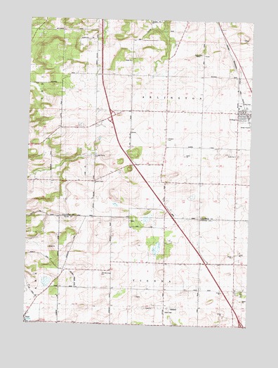
Arlington, WI USGS Topographic Map
Click on map above to begin viewing in our Map Viewer.

This topographic map contains these locations and features:
Feature Name Type Latitude Longitude GNIS ID View Map
ArlingtonPopulated PlaceN43.3380°W89.3804°1560939View Map
Arlington CemeteryCemeteryN43.3261°W89.4229°1560941View Map
Arlington Elementary SchoolSchoolN43.3395°W89.3821°1842927View Map
Arlington Fire RescueBuildingN43.3387°W89.3797°2697996View Map
Arlington Prairie CemeteryCemeteryN43.3189°W89.4623°1560943View Map
Arlington Prairie ChurchChurchN43.3097°W89.4621°1560944View Map
Arlington Sewage Treatment PlantLocaleN43.3328°W89.3772°2723898View Map
Arlington United Methodist ChurchChurchN43.3369°W89.3821°1842928View Map
Dane Immanuel CemeteryCemeteryN43.2543°W89.4994°2781270View Map
Eberle Ranch AirportAirportN43.2692°W89.4869°2444178View Map
Evangelical CemeteryCemeteryN43.3230°W89.3921°1564717View Map
One Hundred Mile Grove CemeteryCemeteryN43.2717°W89.4561°1570829View Map
Poynette QuarryMineN43.3681°W89.3800°2634035View Map
Saint Peters Lutheran ChurchChurchN43.3355°W89.3801°1843031View Map
Town of ArlingtonCivilN43.3376°W89.4237°1582714View Map
Town of ViennaCivilN43.2504°W89.4231°1584331View Map
Village of DaneCivilN43.2500°W89.4996°1583047View Map
WIBU-AM (Poynette)TowerN43.3605°W89.4023°1582568View Map

Note: Coordinates in the location and feature list above are referenced to NAD83 datum.


Copyright (C) 2008-2025 Ryan Niemi / Sunset Dynamics ... All Rights Reserved