TopoQuest Logo
Do you find TopoQuest useful?
Help keep TopoQuest running and adding new maps/features by donating!
Bitcoin:  19c7KJd3qBynnjoSw5npx9KScwjBe4ifkT
Litecoin:  LXs6TkuXGGXo1vDsWCkWVdjQX94eUKd6ui
Home View Maps Find Maps Find Places Resources & Links


Waupun South, Wisconsin Topographic Map

USGS Map Title: Waupun South, WI
USGS Map MRC: 43088E6
DRG (GeoTIFF) Download: o43088e6.tif


Neighboring USGS Topographic Map Quads:


  Brandon, WI  
43088F7
 

  Waupun North, WI  
43088F6
 

  Oakfield, WI  
43088F5
 

  Buckhorn Corner, WI  
43088E7
 

  Waupun South, WI  
43088E6
 

  Mayville North, WI  
43088E5
 

  Beaver Dam, WI  
43088D7
 

  Horicon, WI  
43088D6
 

  Mayville South, WI  
43088D5


Map MRC Location:

N44°
W89°
N44°
W88°
H8 H7 H6 H5 H4 H3 H2 H1
G8 G7 G6 G5 G4 G3 G2 G1
F8 F7 F6 F5 F4 F3 F2 F1
E8 E7 E6 E5 E4 E3 E2 E1
D8 D7 D6 D5 D4 D3 D2 D1
C8 C7 C6 C5 C4 C3 C2 C1
B8 B7 B6 B5 B4 B3 B2 B1
A8 A7 A6 A5 A4 A3 A2 A1
N43°
W89°
N43°
W88°

Waupun South, WI USGS 1:24K Topographic Map Preview:
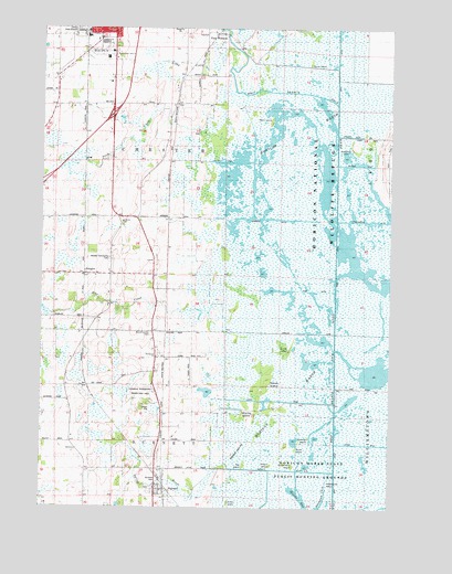
Waupun South, WI USGS Topographic Map
Click on map above to begin viewing in our Map Viewer.

This topographic map contains these locations and features:
Feature Name Type Latitude Longitude GNIS ID View Map
Ames IslandIslandN43.5014°W88.6826°1850620View Map
Apple IslandIslandN43.5147°W88.6593°1560908View Map
AtwaterPopulated PlaceN43.5608°W88.7346°1577499View Map
Atwater Community CemeteryCemeteryN43.5647°W88.7257°1850624View Map
BurnettPopulated PlaceN43.5047°W88.7070°1562430View Map
Burnett Census Designated PlaceCensusN43.5065°W88.7084°2586461View Map
Burnett DitchCanalN43.5100°W88.6629°1850643View Map
Burnett FlowageReservoirN43.5126°W88.6729°1793512View Map
Burnett Post OfficePost OfficeN43.5039°W88.7067°2723981View Map
Burnett Union CemeteryCemeteryN43.5453°W88.7107°1850644View Map
Burnett Volunteer Fire DepartmentBuildingN43.5050°W88.7108°2697486View Map
Central State HospitalHospitalN43.6242°W88.7371°1850646View Map
Chester SchoolSchoolN43.5744°W88.7212°1850648View Map
Clarks DitchCanalN43.5167°W88.6282°1850651View Map
Clubhouse DitchCanalN43.5933°W88.6418°1850654View Map
Colleins DitchCanalN43.5894°W88.6365°1850657View Map
Dodge Correctional InstitutionBuildingN43.6241°W88.7397°2756153View Map
East WaupunPopulated PlaceN43.6242°W88.6907°1577583View Map
Elmwood SchoolSchoolN43.5275°W88.7401°1564589View Map
Emmanuel ChurchChurchN43.5394°W88.7079°1566868View Map
Gardner IslandIslandN43.5183°W88.6532°1565406View Map
Goose IslandIslandN43.5417°W88.6626°1565646View Map
Hall IslandIslandN43.5111°W88.6765°1565986View Map
Horicon Haven FarmsLocaleN43.5314°W88.6964°2724060View Map
Horicon MarshSwampN43.5497°W88.6559°1566697View Map
Horicon Marsh-Burnett DamDamN43.5117°W88.6718°1793511View Map
Horicon National Wildlife RefugeParkN43.5769°W88.6457°1566699View Map
John C Burke Correctional Center SchoolSchoolN43.6208°W88.7362°2716441View Map
Karstedt ParkParkN43.5075°W88.7082°1850752View Map
Libby CreekStreamN43.6203°W88.6812°1568006View Map
Luebke DitchCanalN43.5278°W88.6629°1850768View Map
Main DitchCanalN43.5336°W88.6440°1568906View Map
Mieske BayBayN43.5047°W88.6590°1569451View Map
Mill CreekStreamN43.5461°W88.6837°1569473View Map
Misling IslandIslandN43.5230°W88.6748°1569604View Map
Neitzels DitchCanalN43.5903°W88.6854°1850789View Map
Oakview SchoolSchoolN43.6047°W88.7254°1570714View Map
Peachey Brothers ElevatorLocaleN43.5047°W88.7047°2724062View Map
Plum CreekStreamN43.5936°W88.6876°1571690View Map
Pool One 220ReservoirN43.5228°W88.6456°1793129View Map
Radloff IslandsIslandN43.5147°W88.6815°1850801View Map
Rank IslandIslandN43.6017°W88.6671°1572077View Map
Schaumbergs DitchCanalN43.5747°W88.6348°1850854View Map
Sommers DitchCanalN43.5753°W88.6670°1850861View Map
Spring BrookStreamN43.5100°W88.6759°1574591View Map
Squak IslandIslandN43.5289°W88.6712°1574747View Map
Steamboat ChannelChannelN43.5042°W88.6476°1850866View Map
Steamboat IslandIslandN43.5064°W88.6465°1574838View Map
Stony IslandIslandN43.6158°W88.6540°1574956View Map
Strawberry IslandIslandN43.5111°W88.6587°1574976View Map
Strooks DitchCanalN43.5972°W88.6398°1850868View Map
Stub DitchCanalN43.5567°W88.6526°1850869View Map
Town of BurnettCivilN43.5024°W88.7049°1582890View Map
Town of ChesterCivilN43.5870°W88.7030°1582950View Map
Townline DitchCanalN43.5455°W88.6340°1850878View Map
Townline SchoolSchoolN43.5464°W88.7104°1575553View Map
Upper Horicon 2WP629 DamDamN43.5250°W88.6451°1793128View Map
West Branch Rock RiverStreamN43.6053°W88.6440°1576478View Map
Willow IslandIslandN43.5114°W88.6670°1576792View Map

Note: Coordinates in the location and feature list above are referenced to NAD83 datum.


Copyright (C) 2008-2024 Ryan Niemi / Sunset Dynamics ... All Rights Reserved