TopoQuest Logo
Do you find TopoQuest useful?
Help keep TopoQuest running and adding new maps/features by donating!
Bitcoin:  19c7KJd3qBynnjoSw5npx9KScwjBe4ifkT
Litecoin:  LXs6TkuXGGXo1vDsWCkWVdjQX94eUKd6ui
Home View Maps Find Maps Find Places Resources & Links


Buckhorn Corner, Wisconsin Topographic Map

USGS Map Title: Buckhorn Corner, WI
USGS Map MRC: 43088E7
DRG (GeoTIFF) Download: o43088e7.tif


Neighboring USGS Topographic Map Quads:


  Markesan, WI  
43088F8
 

  Brandon, WI  
43088F7
 

  Waupun North, WI  
43088F6
 

  Fox Lake, WI  
43088E8
 

  Buckhorn Corner, WI  
43088E7
 

  Waupun South, WI  
43088E6
 

  Lost Lake, WI  
43088D8
 

  Beaver Dam, WI  
43088D7
 

  Horicon, WI  
43088D6


Map MRC Location:

N44°
W89°
N44°
W88°
H8 H7 H6 H5 H4 H3 H2 H1
G8 G7 G6 G5 G4 G3 G2 G1
F8 F7 F6 F5 F4 F3 F2 F1
E8 E7 E6 E5 E4 E3 E2 E1
D8 D7 D6 D5 D4 D3 D2 D1
C8 C7 C6 C5 C4 C3 C2 C1
B8 B7 B6 B5 B4 B3 B2 B1
A8 A7 A6 A5 A4 A3 A2 A1
N43°
W89°
N43°
W88°

Buckhorn Corner, WI USGS 1:24K Topographic Map Preview:
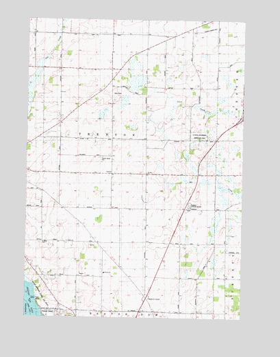
Buckhorn Corner, WI USGS Topographic Map
Click on map above to begin viewing in our Map Viewer.

This topographic map contains these locations and features:
Feature Name Type Latitude Longitude GNIS ID View Map
Boomer SchoolSchoolN43.5308°W88.7915°1562065View Map
Buckhorn CornerPopulated PlaceN43.5083°W88.8059°1577530View Map
Climax SchoolSchoolN43.5972°W88.8276°1563192View Map
Dodge County Waterfowl Production AreaParkN43.5674°W88.7834°2765574View Map
Excelsior SchoolSchoolN43.6186°W88.8482°1564782View Map
Highland Memorial GardensCemeteryN43.5472°W88.7815°1850734View Map
Kirsch IslandIslandN43.5067°W88.8707°1850754View Map
Lake View SchoolSchoolN43.5169°W88.8676°1567763View Map
Marys CemeteryCemeteryN43.5311°W88.8662°1569108View Map
Oak Lawn SchoolSchoolN43.5964°W88.7751°1570664View Map
Oakwood SchoolSchoolN43.5744°W88.7654°1570729View Map
Prairie View SchoolSchoolN43.5314°W88.8354°1571899View Map
Saint John ChurchChurchN43.5608°W88.8057°1573010View Map
Sunset BeachPopulated PlaceN43.5017°W88.8657°1575108View Map
Town of TrentonCivilN43.5687°W88.8262°1584292View Map
Trenton Center CemeteryCemeteryN43.5672°W88.8315°1575598View Map
Trenton Elementary SchoolSchoolN43.5610°W88.8267°1575599View Map
Trenton Elementary SchoolSchoolN43.5189°W88.8293°1850879View Map
Waupun AirportAirportN43.6237°W88.7661°1582261View Map
Willowbrook FarmLocaleN43.5469°W88.7644°2724059View Map

Note: Coordinates in the location and feature list above are referenced to NAD83 datum.


Copyright (C) 2008-2025 Ryan Niemi / Sunset Dynamics ... All Rights Reserved