TopoQuest Logo
Do you find TopoQuest useful?
Help keep TopoQuest running and adding new maps/features by donating!
Bitcoin:  19c7KJd3qBynnjoSw5npx9KScwjBe4ifkT
Litecoin:  LXs6TkuXGGXo1vDsWCkWVdjQX94eUKd6ui
Home View Maps Find Maps Find Places Resources & Links


Chipley, Florida Topographic Map

USGS Map Title: Chipley, FL
USGS Map MRC: 30085G5
DRG (GeoTIFF) Download: o30085g5.tif


Neighboring USGS Topographic Map Quads:


  Esto, FL  
30085H6
 

  Graceville, FL  
30085H5
 

  Campbellton, FL  
30085H4
 

  Bonifay, FL  
30085G6
 

  Chipley, FL  
30085G5
 

  Cottondale West, FL  
30085G4
 

  Poplar Head, FL  
30085F6
 

  Wausau, FL  
30085F5
 

  Alford, FL  
30085F4


Map MRC Location:

N31°
W86°
N31°
W85°
H8 H7 H6 H5 H4 H3 H2 H1
G8 G7 G6 G5 G4 G3 G2 G1
F8 F7 F6 F5 F4 F3 F2 F1
E8 E7 E6 E5 E4 E3 E2 E1
D8 D7 D6 D5 D4 D3 D2 D1
C8 C7 C6 C5 C4 C3 C2 C1
B8 B7 B6 B5 B4 B3 B2 B1
A8 A7 A6 A5 A4 A3 A2 A1
N30°
W86°
N30°
W85°

Chipley, FL USGS 1:24K Topographic Map Preview:
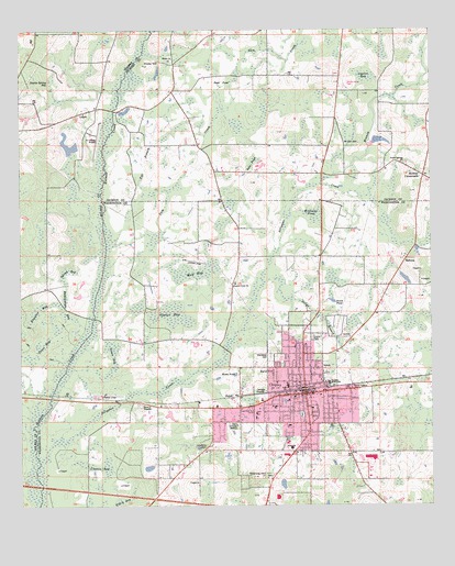
Chipley, FL USGS Topographic Map
Click on map above to begin viewing in our Map Viewer.

This topographic map contains these locations and features:
Feature Name Type Latitude Longitude GNIS ID View Map
Alligator CreekStreamN30.7621°W85.6191°277792View Map
BahomaPopulated PlaceN30.8146°W85.5080°295106View Map
Big BranchStreamN30.8591°W85.6008°278640View Map
Chance BaySwampN30.7603°W85.5991°280288View Map
ChipleyPopulated PlaceN30.7819°W85.5385°280398View Map
Chipley DivisionCivilN30.7589°W85.5417°1935723View Map
Chipley Fire DepartmentBuildingN30.7780°W85.5530°2644005View Map
Chipley High SchoolSchoolN30.7917°W85.5442°299352View Map
Chipley Police DepartmentBuildingN30.7780°W85.5531°2754479View Map
Chipley Post OfficePost OfficeN30.7820°W85.5390°2765673View Map
City of ChipleyCivilN30.7756°W85.5404°2404049View Map
Dam PondSwampN30.8408°W85.5540°281265View Map
Double Spring BaySwampN30.8591°W85.6140°281719View Map
Duck PondSwampN30.8605°W85.5636°281830View Map
Grass BaySwampN30.7929°W85.6178°283292View Map
Green BaySwampN30.7897°W85.5960°283370View Map
Gum CreekStreamN30.8102°W85.5997°283532View Map
Harrel Square Shopping CenterLocaleN30.7635°W85.5410°295821View Map
Helms BranchStreamN30.8085°W85.5513°283863View Map
Hicks HillSummitN30.8660°W85.5869°283974View Map
Holmes Creek ChurchChurchN30.8085°W85.5594°284192View Map
Hoover DitchStreamN30.8696°W85.5502°284243View Map
HulawPopulated PlaceN30.7794°W85.5583°295370View Map
Kate M Smith Elementary SchoolSchoolN30.7760°W85.5474°299350View Map
Lawlor BaySwampN30.8627°W85.5200°285400View Map
Limestone CemeteryCemeteryN30.7657°W85.5685°285533View Map
Minnow CreekStreamN30.8344°W85.5324°286967View Map
Mount Zion CemeteryCemeteryN30.8452°W85.5216°287335View Map
Nearing HillSummitN30.7580°W85.5544°287564View Map
Northwest Florida Community HospitalHospitalN30.7656°W85.5429°298816View Map
Northwest Florida Community Hospital HeliportAirportN30.7644°W85.5419°309324View Map
Notch PondSwampN30.8051°W85.5297°287906View Map
Poplar Springs ChurchChurchN30.8396°W85.5077°289212View Map
Rattlesnake BaySwampN30.7995°W85.6091°289480View Map
Reddick Mill CreekStreamN30.8585°W85.5960°289562View Map
Register BaySwampN30.8016°W85.6186°289627View Map
Richter CrossroadsPopulated PlaceN30.8369°W85.5022°294905View Map
Roulbac Middle SchoolSchoolN30.7821°W85.5310°299351View Map
Salem ChurchChurchN30.8671°W85.5794°290418View Map
Sand HillSummitN30.7844°W85.5485°290521View Map
Sids Strip (historical)AirportN30.8144°W85.5719°309322View Map
Spence BaySwampN30.8002°W85.5786°291496View Map
Spring BaySwampN30.8106°W85.6115°291516View Map
Titi BranchGutN30.8399°W85.5874°292315View Map
Tri-County AirportAirportN30.8471°W85.6032°309282View Map
Vosika's Airport (historical)AirportN30.7794°W85.6011°309323View Map
Washington County Sheriff's OfficeBuildingN30.7787°W85.5415°2754525View Map
Washington-Holmes Area Vocational Technical CenterSchoolN30.7744°W85.5527°299349View Map
Watts PondLakeN30.7848°W85.5593°292947View Map
WBGC-AM (Chipley)TowerN30.7721°W85.5585°310038View Map
Williams PondSwampN30.8270°W85.5357°293339View Map
Wolf BaySwampN30.8130°W85.5725°293450View Map

Note: Coordinates in the location and feature list above are referenced to NAD83 datum.


Copyright (C) 2008-2025 Ryan Niemi / Sunset Dynamics ... All Rights Reserved