TopoQuest Logo
Do you find TopoQuest useful?
Help keep TopoQuest running and adding new maps/features by donating!
Bitcoin:  19c7KJd3qBynnjoSw5npx9KScwjBe4ifkT
Litecoin:  LXs6TkuXGGXo1vDsWCkWVdjQX94eUKd6ui
Home View Maps Find Maps Find Places Resources & Links


Waverly Mills, South Carolina Topographic Map

USGS Map Title: Waverly Mills, SC
USGS Map MRC: 33079D2
DRG (GeoTIFF) Download: o33079d2.tif


Neighboring USGS Topographic Map Quads:


  Carvers Bay, SC  
33079E3
 

  Plantersville, SC  
33079E2
 

  Brookgreen, SC  
33079E1
 

  Georgetown North, SC  
33079D3
 

  Waverly Mills, SC  
33079D2
 

  Magnolia Beach, SC  
33079D1
 

  Georgetown South, SC  
33079C3
 

  North Island, SC  
33079C2


Map MRC Location:

N34°
W80°
N34°
W79°
H8 H7 H6 H5 H4 H3 H2 H1
G8 G7 G6 G5 G4 G3 G2 G1
F8 F7 F6 F5 F4 F3 F2 F1
E8 E7 E6 E5 E4 E3 E2 E1
D8 D7 D6 D5 D4 D3 D2 D1
C8 C7 C6 C5 C4 C3 C2 C1
B8 B7 B6 B5 B4 B3 B2 B1
A8 A7 A6 A5 A4 A3 A2 A1
N33°
W80°
N33°
W79°

Waverly Mills, SC USGS 1:24K Topographic Map Preview:
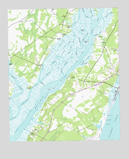
Waverly Mills, SC USGS Topographic Map
Click on map above to begin viewing in our Map Viewer.

This topographic map contains these locations and features:
Feature Name Type Latitude Longitude GNIS ID View Map
All Saints CemeteryCemeteryN33.4674°W79.1400°1232235View Map
All Saints ChurchChurchN33.4677°W79.1395°1244863View Map
Alliston EstateLocaleN33.4191°W79.1395°1232236View Map
Arcadia PlantationLocaleN33.3849°W79.2200°1244919View Map
Arundel PlantationLocaleN33.4835°W79.1806°1220240View Map
Belin United Methodist ChurchChurchN33.4589°W79.1399°2490188View Map
Benvenue PlantationLocaleN33.4724°W79.1900°1220507View Map
Bethel ChurchChurchN33.4929°W79.1845°1246779View Map
Bethel Church (historical)ChurchN33.4943°W79.2064°1232261View Map
Betts Village School (historical)SchoolN33.3921°W79.1692°1232263View Map
Birds NestPopulated PlaceN33.4113°W79.1328°1232265View Map
Black RiverStreamN33.3988°W79.2473°1246903View Map
Bridge Pond Dam D-3513DamN33.3752°W79.1581°1240132View Map
Bullins CreekStreamN33.4921°W79.1545°1221115View Map
Butler CreekStreamN33.4627°W79.1620°1221165View Map
Butler IslandIslandN33.4246°W79.2012°1221166View Map
Caledonia CreekStreamN33.4477°W79.1695°1221198View Map
Caledonia PlantationLocaleN33.4577°W79.1534°1232276View Map
Carr CreekStreamN33.4543°W79.1909°1247172View Map
Chapel CreekPopulated PlaceN33.4752°W79.1387°1232287View Map
Chapel Creek VillasPopulated PlaceN33.4657°W79.1445°1232288View Map
Clark Estate (historical)LocaleN33.4113°W79.1414°1232295View Map
Darlngton PlantationLocaleN33.4746°W79.1870°1247489View Map
Debidue BeachBeachN33.3827°W79.1470°1247513View Map
Duncan CreekStreamN33.4474°W79.1648°1222144View Map
Ebenezer Church (historical)ChurchN33.4566°W79.1434°1232314View Map
FraservillePopulated PlaceN33.4429°W79.1312°1222543View Map
Gatson BaySwampN33.4822°W79.2319°1222665View Map
Gray Mans CovePopulated PlaceN33.4349°W79.1320°1232344View Map
Hagley EstatesPopulated PlaceN33.4313°W79.1645°1232347View Map
Hagley LandingLocaleN33.4363°W79.1817°1232348View Map
Hagley PlantationLocaleN33.4338°W79.1770°1222965View Map
Heritage Golf ClubLocaleN33.4403°W79.1619°2490020View Map
Heritage PlantationLocaleN33.4521°W79.1553°1232350View Map
Holly HillIslandN33.4974°W79.1495°1223232View Map
Holy Cross Church (historical)ChurchN33.4291°W79.1487°1232353View Map
JacksonPopulated PlaceN33.4993°W79.1989°1231425View Map
Jericho CreekGutN33.4482°W79.1950°1246164View Map
Kiethfield PlantationLocaleN33.4493°W79.2467°1246242View Map
Litchfield PlantationLocaleN33.4779°W79.1375°1232385View Map
Little Carr CreekStreamN33.4543°W79.1889°1246392View Map
Longwater SwampSwampN33.4521°W79.2298°1224190View Map
Lowcountry Day SchoolSchoolN33.4373°W79.1368°2486482View Map
MarysvillePopulated PlaceN33.4277°W79.1512°1224356View Map
Marysville ChurchChurchN33.4216°W79.1756°1232391View Map
Marysville School (historical)SchoolN33.4057°W79.1978°1232392View Map
Middleton CutChannelN33.4296°W79.2117°1224478View Map
Midway Fire Department DebordieuBuildingN33.3769°W79.1769°2368258View Map
Midway Fire Department Station 82BuildingN33.4329°W79.1434°2368389View Map
Milton Hall PlantationLocaleN33.4652°W79.2017°1251715View Map
Nightingale PlantationLocaleN33.4460°W79.2134°1249872View Map
Nightingale Pond Dam D-3592DamN33.4485°W79.2181°1240133View Map
Oatland CreekStreamN33.4932°W79.1437°1225157View Map
Pawley's Island Montessori SchoolSchoolN33.4301°W79.1466°2486422View Map
Pawleys CreekStreamN33.4507°W79.1839°1232526View Map
Pawleys InletBayN33.3988°W79.1389°1253480View Map
Pawleys Island Presbyterian ChurchChurchN33.4353°W79.1355°2490194View Map
Pawleys Island Wastewater Treatment PlantLocaleN33.4477°W79.1413°2490486View Map
Pawleys PlantationPopulated PlaceN33.4254°W79.1500°1232421View Map
Pawleys Plantation Golf and Country ClubLocaleN33.4201°W79.1454°2490042View Map
Pawleys RetreatPopulated PlaceN33.4579°W79.1398°1232422View Map
Pawleys WoodsPopulated PlaceN33.4246°W79.1389°1232423View Map
Pee Dee Game Management AreaParkN33.4743°W79.1775°1232424View Map
Pee Dee River Rice Planters Historic DistrictParkN33.4585°W79.1831°1232527View Map
Rabbit IslandIslandN33.4796°W79.1648°1225726View Map
River ClubLocaleN33.4687°W79.1296°2490051View Map
River Golf ClubLocaleN33.4646°W79.1303°1232444View Map
River Oaks EstatesPopulated PlaceN33.4621°W79.1503°1232445View Map
Rossdhu PlantationLocaleN33.4643°W79.1470°1251717View Map
Schooner CreekStreamN33.4535°W79.1695°1250812View Map
Sea Gull Golf ClubLocaleN33.4338°W79.1291°2490056View Map
Sea Gull Golf CourseLocaleN33.4279°W79.1637°1232474View Map
SimmonsvillePopulated PlaceN33.4196°W79.1781°1226632View Map
Squirrel CreekStreamN33.4888°W79.1512°1226855View Map
True BluePopulated PlaceN33.4474°W79.1498°1232485View Map
Waccamaw Elementary SchoolSchoolN33.4554°W79.1358°1232492View Map
Waccamaw High SchoolSchoolN33.4516°W79.1456°1232493View Map
Waccamaw Neck DivisionCivilN33.3876°W79.1283°1938453View Map
Waterford HeightsPopulated PlaceN33.4121°W79.1400°1232499View Map
Waverly CreekStreamN33.4752°W79.1537°1227445View Map
Waverly MillsPopulated PlaceN33.4732°W79.1481°1251340View Map
Wedgefield PlantationLocaleN33.4246°W79.2456°1232501View Map
White House PlantationLocaleN33.4246°W79.2264°1227535View Map
Willbrook PlantationLocaleN33.4835°W79.1334°1251718View Map
Willbrook Plantation Golf ClubLocaleN33.4899°W79.1269°2490067View Map
Woodville AcresPopulated PlaceN33.4627°W79.1359°1232512View Map
Woodville IslandIslandN33.4688°W79.1612°1230521View Map
WSYN-FM (Georgetown)TowerN33.4391°W79.1362°1252488View Map

Note: Coordinates in the location and feature list above are referenced to NAD83 datum.


Copyright (C) 2008-2025 Ryan Niemi / Sunset Dynamics ... All Rights Reserved