TopoQuest Logo
Do you find TopoQuest useful?
Help keep TopoQuest running and adding new maps/features by donating!
Bitcoin:  19c7KJd3qBynnjoSw5npx9KScwjBe4ifkT
Litecoin:  LXs6TkuXGGXo1vDsWCkWVdjQX94eUKd6ui
Home View Maps Find Maps Find Places Resources & Links


Plantersville, South Carolina Topographic Map

USGS Map Title: Plantersville, SC
USGS Map MRC: 33079E2
DRG (GeoTIFF) Download: o33079e2.tif


Neighboring USGS Topographic Map Quads:


  Outland, SC  
33079F3
 

  Yauhannah, SC  
33079F2
 

  Bucksville, SC  
33079F1
 

  Carvers Bay, SC  
33079E3
 

  Plantersville, SC  
33079E2
 

  Brookgreen, SC  
33079E1
 

  Georgetown North, SC  
33079D3
 

  Waverly Mills, SC  
33079D2
 

  Magnolia Beach, SC  
33079D1


Map MRC Location:

N34°
W80°
N34°
W79°
H8 H7 H6 H5 H4 H3 H2 H1
G8 G7 G6 G5 G4 G3 G2 G1
F8 F7 F6 F5 F4 F3 F2 F1
E8 E7 E6 E5 E4 E3 E2 E1
D8 D7 D6 D5 D4 D3 D2 D1
C8 C7 C6 C5 C4 C3 C2 C1
B8 B7 B6 B5 B4 B3 B2 B1
A8 A7 A6 A5 A4 A3 A2 A1
N33°
W80°
N33°
W79°

Plantersville, SC USGS 1:24K Topographic Map Preview:
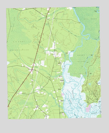
Plantersville, SC USGS Topographic Map
Click on map above to begin viewing in our Map Viewer.

This topographic map contains these locations and features:
Feature Name Type Latitude Longitude GNIS ID View Map
Bates Hill PlantationLocaleN33.5735°W79.1673°1220359View Map
BelinPopulated PlaceN33.5179°W79.1437°1231042View Map
Belle Reve PlantationLocaleN33.5477°W79.1762°1245045View Map
Birdfield SchoolSchoolN33.5041°W79.1970°1220755View Map
Broton LakeSwampN33.5554°W79.1312°1220998View Map
Bull IslandIslandN33.6249°W79.1398°1221100View Map
Chapel CreekStreamN33.5116°W79.1750°1221503View Map
Chicora Wood PlantationLocaleN33.5188°W79.1756°1247283View Map
Cooter CreekStreamN33.5171°W79.1537°1221750View Map
Cypress CreekStreamN33.5496°W79.1764°1221900View Map
Exchange PlantationLocaleN33.5329°W79.1778°1222324View Map
Georgetown County Rural Fire Department Station 6BuildingN33.5197°W79.1302°2368316View Map
Georgetown Fire Department Station 8BuildingN33.5623°W79.2134°2368186View Map
GilliardPopulated PlaceN33.5143°W79.2100°1231315View Map
Glenmore PlantationLocaleN33.5524°W79.1798°1232340View Map
Guendalose CreekStreamN33.5054°W79.1475°1245858View Map
Hasty Point PlantationLocaleN33.5427°W79.1739°1223081View Map
Holly Grove PlantationLocaleN33.5621°W79.1770°1223231View Map
Horseshoe LakeLakeN33.6199°W79.1278°1246076View Map
Indian LakeLakeN33.5707°W79.1348°1223445View Map
Joe BaySwampN33.5670°W79.1372°1223581View Map
Lower Topsaw LandingPopulated PlaceN33.6082°W79.1514°1231508View Map
Mount Arena Plantation (historical)LocaleN33.5168°W79.1275°1232401View Map
Mount Carmel ChurchChurchN33.5468°W79.1928°1249558View Map
Mount RenaPopulated PlaceN33.5182°W79.1295°1224790View Map
Mount TaborPopulated PlaceN33.6179°W79.1948°1231568View Map
Mount Tabor ChurchChurchN33.6118°W79.1950°1249681View Map
Mount Zion ChurchChurchN33.5760°W79.1853°1232408View Map
Myersville SchoolSchoolN33.5721°W79.1864°1224913View Map
New Bethel Baptist ChurchChurchN33.5043°W79.1975°1232413View Map
Pawleys CreekStreamN33.5118°W79.1273°1225325View Map
PlantersvillePopulated PlaceN33.5554°W79.2153°1225523View Map
Plantersville DivisionCivilN33.5564°W79.2264°1938386View Map
Plantersville Elementary SchoolSchoolN33.5297°W79.2106°1232431View Map
Plantersville Senior CenterBuildingN33.5298°W79.2107°2489976View Map
Pole Castle BranchStreamN33.5929°W79.1484°1250201View Map
Prince Frederick ChapelChurchN33.5549°W79.2145°1232435View Map
Prince Frederick ChurchChurchN33.5060°W79.1798°1250245View Map
Rose Bank PlantationLocaleN33.5266°W79.1781°1251716View Map
RuinsvilleLocaleN33.5393°W79.1298°1226065View Map
Ruinville Plantation (historical)LocaleN33.5371°W79.1292°1232451View Map
Saint Mark SchoolSchoolN33.5293°W79.2295°1226184View Map
Saint PaulsPopulated PlaceN33.5760°W79.1856°1231758View Map
Saint Pauls BranchStreamN33.5535°W79.1748°1226234View Map
Sandy IslandIslandN33.5677°W79.1503°1226367View Map
Sandy Island SchoolSchoolN33.5210°W79.1295°1226369View Map
Thoroughfare CreekStreamN33.5043°W79.1417°1251165View Map
Upper Topsaw LandingPopulated PlaceN33.6249°W79.1612°1227992View Map
Waccamaw National Wildlife RefugeParkN33.5819°W79.1326°2765544View Map

Note: Coordinates in the location and feature list above are referenced to NAD83 datum.


Copyright (C) 2008-2025 Ryan Niemi / Sunset Dynamics ... All Rights Reserved