TopoQuest Logo
Do you find TopoQuest useful?
Help keep TopoQuest running and adding new maps/features by donating!
Bitcoin:  19c7KJd3qBynnjoSw5npx9KScwjBe4ifkT
Litecoin:  LXs6TkuXGGXo1vDsWCkWVdjQX94eUKd6ui
Home View Maps Find Maps Find Places Resources & Links


Waynesville, Georgia Topographic Map

USGS Map Title: Waynesville, GA
USGS Map MRC: 31081B7
DRG (GeoTIFF) Download: o31081b7.tif


Neighboring USGS Topographic Map Quads:


  Hortense, GA  
31081C8
 

  Browntown, GA  
31081C7
 

  Thalmann, GA  
31081C6
 

  Nahunta, GA  
31081B8
 

  Waynesville, GA  
31081B7
 

  Bladen, GA  
31081B6
 

  Boons Lake, GA  
31081A8
 

  Tarboro, GA  
31081A7
 

  Waverly, GA  
31081A6


Map MRC Location:

N32°
W82°
N32°
W81°
H8 H7 H6 H5 H4 H3 H2 H1
G8 G7 G6 G5 G4 G3 G2 G1
F8 F7 F6 F5 F4 F3 F2 F1
E8 E7 E6 E5 E4 E3 E2 E1
D8 D7 D6 D5 D4 D3 D2 D1
C8 C7 C6 C5 C4 C3 C2 C1
B8 B7 B6 B5 B4 B3 B2 B1
A8 A7 A6 A5 A4 A3 A2 A1
N31°
W82°
N31°
W81°

Waynesville, GA USGS 1:24K Topographic Map Preview:
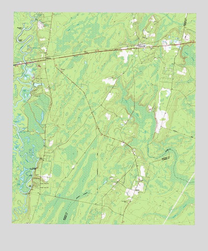
Waynesville, GA USGS Topographic Map
Click on map above to begin viewing in our Map Viewer.

This topographic map contains these locations and features:
Feature Name Type Latitude Longitude GNIS ID View Map
Abrahams LakeLakeN31.2261°W81.8636°310376View Map
Abrams BluffCliffN31.2291°W81.8623°349000View Map
Abrams Bluff CutChannelN31.2261°W81.8659°349001View Map
Ammons CemeteryCemeteryN31.2419°W81.8548°310515View Map
Ammons FerryLocaleN31.2399°W81.8684°310516View Map
Ammons Ferry Bridge (historical)BridgeN31.2391°W81.8687°334942View Map
AtkinsonPopulated PlaceN31.2233°W81.8526°331063View Map
Atkinson Baptist ChurchChurchN31.2219°W81.8518°335807View Map
Atkinson LakeLakeN31.2148°W81.8638°310657View Map
Atkinson Volunteer Fire DepartmentBuildingN31.2236°W81.8432°2604854View Map
Bonnett LakeLakeN31.1883°W81.8701°311650View Map
Brailey SwampSwampN31.1336°W81.7598°311716View Map
Christian Fellowship ChurchChurchN31.2355°W81.8496°335814View Map
Coleridge (historical)Populated PlaceN31.2422°W81.7579°1671477View Map
Daniels CemeteryCemeteryN31.1513°W81.7876°313290View Map
Deerwood LakeReservoirN31.2069°W81.8598°338070View Map
Deerwood Lake DamDamN31.2069°W81.8598°338069View Map
Ditch LakeLakeN31.1977°W81.8651°313489View Map
Doe LakeLakeN31.1800°W81.8693°313521View Map
East Side ChurchChurchN31.2369°W81.7815°313787View Map
Felton LakeLakeN31.1635°W81.8571°349016View Map
First African ChurchChurchN31.2447°W81.7757°314130View Map
Flanders Shady BluffCliffN31.1577°W81.8582°314169View Map
Gibson CemeteryCemeteryN31.2391°W81.7818°335817View Map
Golden Isles SpeedwayLocaleN31.2361°W81.7559°1671521View Map
Happy LandingPopulated PlaceN31.1633°W81.8565°326320View Map
Heads LakeLakeN31.2472°W81.8596°315275View Map
Highsmith CemeteryCemeteryN31.2294°W81.7821°315396View Map
Homeward CemeteryCemeteryN31.1386°W81.7957°315603View Map
Honey BluffCliffN31.2324°W81.8696°315606View Map
Hope ChapelChurchN31.2219°W81.8521°315628View Map
Jackson CemeteryCemeteryN31.1524°W81.8082°316001View Map
Julia LakeLakeN31.2022°W81.8659°316299View Map
King School (historical)SchoolN31.1697°W81.8454°334943View Map
Kings LakeLakeN31.1483°W81.8684°316452View Map
Kings SuckSwampN31.1327°W81.8651°349022View Map
Knights SwampSwampN31.2240°W81.7500°316501View Map
Linda PlantationLocaleN31.1436°W81.8623°316894View Map
Little Rock ChurchChurchN31.2322°W81.7659°317170View Map
Little Satilla School (historical)SchoolN31.1797°W81.8026°334944View Map
Long LakeLakeN31.1692°W81.8724°317370View Map
Lord King BluffCliffN31.1627°W81.8559°349023View Map
Mount Zion ChurchChurchN31.1483°W81.8054°318938View Map
North Camden School (historical)SchoolN31.1305°W81.8137°334953View Map
Old Time ChurchChurchN31.2299°W81.7815°335829View Map
Palmetto South ChurchChurchN31.1741°W81.7987°320174View Map
Pilgrims Rest ChurchChurchN31.2116°W81.8082°320527View Map
Radfords BluffCliffN31.1266°W81.8734°349028View Map
Riverview School (historical)SchoolN31.1569°W81.8551°334946View Map
SalterPopulated PlaceN31.1455°W81.7907°332962View Map
Sandhill ChurchChurchN31.1258°W81.8626°322448View Map
Sandy LakeLakeN31.1842°W81.8726°322490View Map
Seals BaySwampN31.2419°W81.8344°322679View Map
Seals BranchStreamN31.2449°W81.8598°322680View Map
WaynesvillePopulated PlaceN31.2294°W81.7893°324940View Map
Waynesville ChurchChurchN31.2294°W81.7843°335834View Map
Waynesville DivisionCivilN31.2484°W81.8212°1936635View Map
Waynesville Elementary SchoolSchoolN31.2271°W81.7907°2453167View Map
Waynesville Post OfficePost OfficeN31.2294°W81.7868°352103View Map
Waynesville Volunteer Fire DepartmentBuildingN31.2274°W81.7894°2603682View Map
Wiggens CemeteryCemeteryN31.2349°W81.7840°325255View Map

Note: Coordinates in the location and feature list above are referenced to NAD83 datum.


Copyright (C) 2008-2025 Ryan Niemi / Sunset Dynamics ... All Rights Reserved