TopoQuest Logo
Do you find TopoQuest useful?
Help keep TopoQuest running and adding new maps/features by donating!
Bitcoin:  19c7KJd3qBynnjoSw5npx9KScwjBe4ifkT
Litecoin:  LXs6TkuXGGXo1vDsWCkWVdjQX94eUKd6ui
Home View Maps Find Maps Find Places Resources & Links


Hortense, Georgia Topographic Map

USGS Map Title: Hortense, GA
USGS Map MRC: 31081C8
DRG (GeoTIFF) Download: o31081c8.tif


Neighboring USGS Topographic Map Quads:


  Screven, GA  
31082D1
 

  McKinnon, GA  
31081D8
 

  Manningtown, GA  
31081D7
 

  Patterson SE, GA  
31082C1
 

  Hortense, GA  
31081C8
 

  Browntown, GA  
31081C7
 

  Hoboken East, GA  
31082B1
 

  Nahunta, GA  
31081B8
 

  Waynesville, GA  
31081B7


Map MRC Location:

N32°
W82°
N32°
W81°
H8 H7 H6 H5 H4 H3 H2 H1
G8 G7 G6 G5 G4 G3 G2 G1
F8 F7 F6 F5 F4 F3 F2 F1
E8 E7 E6 E5 E4 E3 E2 E1
D8 D7 D6 D5 D4 D3 D2 D1
C8 C7 C6 C5 C4 C3 C2 C1
B8 B7 B6 B5 B4 B3 B2 B1
A8 A7 A6 A5 A4 A3 A2 A1
N31°
W82°
N31°
W81°

Hortense, GA USGS 1:24K Topographic Map Preview:
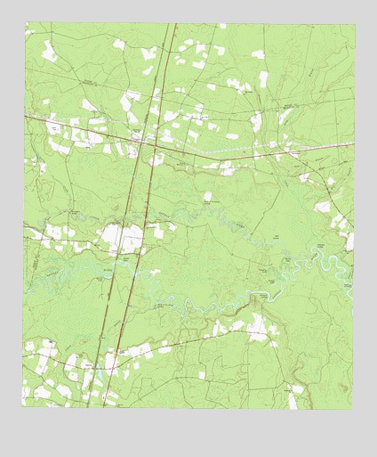
Hortense, GA USGS Topographic Map
Click on map above to begin viewing in our Map Viewer.

This topographic map contains these locations and features:
Feature Name Type Latitude Longitude GNIS ID View Map
Barbers CreekStreamN31.3016°W81.8871°310790View Map
Baxter BluffCliffN31.2919°W81.9682°349003View Map
Baxter CemeteryCemeteryN31.3099°W81.9646°335809View Map
Baxter LakeLakeN31.2978°W81.9628°310871View Map
Bonnet LakeLakeN31.2930°W81.9699°311648View Map
Church House BranchStreamN31.2966°W81.8759°312667View Map
Community ChurchChurchN31.2508°W81.9851°335815View Map
Dreading LakeLakeN31.2938°W81.9047°313623View Map
Five Points ReachChannelN31.2855°W81.9159°349017View Map
HortensePopulated PlaceN31.3366°W81.9562°332031View Map
Hortense ChurchChurchN31.3380°W81.9526°335822View Map
Hortense Memorial ChurchChurchN31.3294°W81.9376°315728View Map
Hortense Post OfficePost OfficeN31.3369°W81.9559°352101View Map
Hortense Volunteer Fire DepartmentBuildingN31.3354°W81.9533°2603804View Map
Humpback BridgeBridgeN31.3136°W81.9818°315815View Map
Indian SwampSwampN31.2799°W81.9865°315915View Map
Lewis CemeteryCemeteryN31.2669°W81.9793°316780View Map
Little Satilla RiverStreamN31.2984°W81.8971°2678025View Map
Long BranchStreamN31.3399°W81.9087°317324View Map
Macedonia ChurchChurchN31.2563°W81.8979°317524View Map
Manson (historical)Populated PlaceN31.3405°W81.9779°334793View Map
Maple SuckSwampN31.2855°W81.9498°349024View Map
Menor School (historical)SchoolN31.3044°W81.9782°334794View Map
Mill BranchStreamN31.3155°W81.8943°318175View Map
Mount Zion ChurchChurchN31.2508°W81.9637°318942View Map
Mouth of the Branch LandingLocaleN31.3163°W81.9309°332444View Map
Mouth of the Swamp LandingLocaleN31.2838°W81.9493°332445View Map
NeedmorePopulated PlaceN31.3336°W81.9001°326417View Map
Page BranchStreamN31.3255°W81.9023°320155View Map
Philadelphia ChurchChurchN31.3522°W81.9162°320429View Map
Philadelphia School (historical)SchoolN31.3533°W81.9184°350597View Map
Pollys LakeLakeN31.2915°W81.9043°320987View Map
RaybonPopulated PlaceN31.2630°W81.9721°326481View Map
Raybon ChurchChurchN31.2663°W81.9793°335830View Map
Robinson Hammock BluffCliffN31.2919°W81.8751°334795View Map
Rosin LandingLocaleN31.2988°W81.8751°334796View Map
Satilla CemeteryCemeteryN31.3405°W81.9871°322572View Map
Satilla CreekStreamN31.3138°W81.9821°322576View Map
Sloan Hill ChurchChurchN31.3441°W81.9326°323083View Map
Spell LandingLocaleN31.3055°W81.9029°333099View Map
Spring LakeLakeN31.2977°W81.9018°323440View Map
Strickland BluffCliffN31.2827°W81.9179°323676View Map
Strickland LakeReservoirN31.2652°W81.9715°340835View Map
Strickland Lake DamDamN31.2652°W81.9715°340834View Map
Strickland LandingLocaleN31.2861°W81.9073°333144View Map
Strickland LandingLocaleN31.3030°W81.8893°333145View Map
Strickland School (historical)SchoolN31.2636°W81.9018°334797View Map
Stricklands ReachChannelN31.2880°W81.9109°349033View Map
Tabernacle Camp GroundLocaleN31.3322°W81.9604°335832View Map
Taylor BranchStreamN31.2966°W81.8759°323939View Map
TrudiePopulated PlaceN31.3002°W81.9643°333267View Map
Twin Rivers ChurchChurchN31.3097°W81.9529°324459View Map

Note: Coordinates in the location and feature list above are referenced to NAD83 datum.


Copyright (C) 2008-2025 Ryan Niemi / Sunset Dynamics ... All Rights Reserved