TopoQuest Logo
Do you find TopoQuest useful?
Help keep TopoQuest running and adding new maps/features by donating!
Bitcoin:  19c7KJd3qBynnjoSw5npx9KScwjBe4ifkT
Litecoin:  LXs6TkuXGGXo1vDsWCkWVdjQX94eUKd6ui
Home View Maps Find Maps Find Places Resources & Links


Wayside, Mississippi Topographic Map

USGS Map Title: Wayside, MS
USGS Map MRC: 33091C1
DRG (GeoTIFF) Download: o33091c1.tif


Neighboring USGS Topographic Map Quads:


  Luna, AR  
33091D2
 

  Greenville, MS  
33091D1
 

  Leland, MS  
33090D8
 

  Red Leaf, AR  
33091C2
 

  Wayside, MS  
33091C1
 

  Arcola, MS  
33090C8
 

  Eminence, AR  
33091B2
 

  Avon, MS  
33091B1
 

  Swan Lake NW, MS  
33090B8


Map MRC Location:

N34°
W92°
N34°
W91°
H8 H7 H6 H5 H4 H3 H2 H1
G8 G7 G6 G5 G4 G3 G2 G1
F8 F7 F6 F5 F4 F3 F2 F1
E8 E7 E6 E5 E4 E3 E2 E1
D8 D7 D6 D5 D4 D3 D2 D1
C8 C7 C6 C5 C4 C3 C2 C1
B8 B7 B6 B5 B4 B3 B2 B1
A8 A7 A6 A5 A4 A3 A2 A1
N33°
W92°
N33°
W91°

Wayside, MS USGS 1:24K Topographic Map Preview:
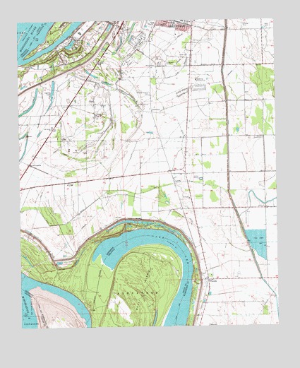
Wayside, MS USGS Topographic Map
Click on map above to begin viewing in our Map Viewer.

This topographic map contains these locations and features:
Feature Name Type Latitude Longitude GNIS ID View Map
Akin SchoolSchoolN33.3740°W91.0487°666169View Map
American BendBendN33.2876°W91.0621°709273View Map
American CutoffChannelN33.2523°W91.0923°69995View Map
Antioch ChurchChurchN33.3607°W91.0426°666319View Map
Ash BayouStreamN33.3565°W91.0248°666388View Map
Bell IslandIslandN33.2612°W91.0682°46354View Map
Bledsoe Lake DamDamN33.3535°W91.0834°682013View Map
Christ Wesleyan Methodist ChurchChurchN33.3743°W91.0562°687172View Map
Country Club AirportAirportN33.3316°W91.0408°680375View Map
Cypress LakeLakeN33.3458°W91.1086°669062View Map
Ditch Number EightCanalN33.3198°W91.1012°669283View Map
Ditch Number Eight ACanalN33.2948°W91.0993°669285View Map
Ditch Number EightyeightCanalN33.3082°W91.0498°669286View Map
Ditch Number FiveCanalN33.3723°W91.0379°669279View Map
Ditch Number Five ACanalN33.3562°W91.0337°669280View Map
Ditch Number NineCanalN33.2887°W91.0379°669287View Map
Ditch Number SevenCanalN33.3371°W91.0654°669282View Map
Ditch Number SixCanalN33.3357°W91.0484°669281View Map
Dredge (historical)Populated PlaceN33.2521°W91.0376°709277View Map
Elwyn Ward Recreational CenterParkN33.3746°W91.0384°687188View Map
Faith Baptist ChurchChurchN33.3690°W91.0479°687192View Map
Faith Baptist SchoolSchoolN33.3690°W91.0479°687193View Map
Greenville Christian SchoolSchoolN33.3623°W91.0382°687216View Map
Greenville Country ClubLocaleN33.3507°W91.0382°711238View Map
Greenville Fire Department Station 8BuildingN33.3590°W91.0603°2665779View Map
Greenville Mall Shopping CenterLocaleN33.3737°W91.0407°687220View Map
James and Bobby Dycus Pond DamDamN33.3151°W91.0201°681989View Map
L and W Catfish Ponds DamDamN33.2918°W91.0068°681980View Map
La Grange TowheadIslandN33.3726°W91.1037°687247View Map
LaGrange CrevasseLakeN33.3655°W91.0992°672234View Map
Lake LeeLakeN33.2796°W91.0454°77279View Map
Lakeview Gardens CemeteryCemeteryN33.3451°W91.0609°672271View Map
Leland CutoffBendN33.3707°W91.1196°51061View Map
Main CanalCanalN33.3254°W91.0234°673088View Map
Mount Calvary ChurchChurchN33.3310°W91.1090°673941View Map
Mount Zion Missionary Baptist ChurchChurchN33.2985°W91.0059°687263View Map
Pilgrims Rest ChurchChurchN33.3035°W91.1023°687285View Map
Riverside Fire DepartmentBuildingN33.2984°W91.0365°2665738View Map
Saint Andrew ChurchChurchN33.3515°W91.0757°677005View Map
Sawgrass LakeLakeN33.3387°W91.1210°677447View Map
Solomon Junior High SchoolSchoolN33.3748°W91.0446°677972View Map
SwiftwaterPopulated PlaceN33.3376°W91.0598°692252View Map
Swiftwater ChurchChurchN33.3026°W91.0423°678504View Map
The Old Evening Star ChurchChurchN33.3168°W91.1207°678665View Map
Unity ChurchChurchN33.3407°W91.0840°679137View Map
Walnut Grove ChurchChurchN33.3410°W91.0659°679302View Map
Walnut PointCapeN33.2579°W91.1071°687333View Map
Warfield LandingLocaleN33.3593°W91.1176°687334View Map
Warfield RevetmentLeveeN33.3576°W91.1237°687336View Map
WaysidePopulated PlaceN33.2690°W91.0337°679401View Map
Wayside Post OfficePost OfficeN33.2698°W91.0345°2768770View Map

Note: Coordinates in the location and feature list above are referenced to NAD83 datum.


Copyright (C) 2008-2025 Ryan Niemi / Sunset Dynamics ... All Rights Reserved