TopoQuest Logo
Do you find TopoQuest useful?
Help keep TopoQuest running and adding new maps/features by donating!
Bitcoin:  19c7KJd3qBynnjoSw5npx9KScwjBe4ifkT
Litecoin:  LXs6TkuXGGXo1vDsWCkWVdjQX94eUKd6ui
Home View Maps Find Maps Find Places Resources & Links


Webber, Kansas Topographic Map

USGS Map Title: Webber, KS
USGS Map MRC: 39098H1
DRG (GeoTIFF) Download: o39098h1.tif


Neighboring USGS Topographic Map Quads:


  Bostwick, NE  
40098A2
 

  Superior, NE  
40098A1
 

  Hardy, NE  
40097A8
 

  Mankato NW, KS  
39098H2
 

  Webber, KS  
39098H1
 

  Scandia NW, KS  
39097H8
 

  Mankato, KS  
39098G2
 

  Montrose, KS  
39098G1
 

  Courtland, KS  
39097G8


Map MRC Location:

N40°
W99°
N40°
W98°
H8 H7 H6 H5 H4 H3 H2 H1
G8 G7 G6 G5 G4 G3 G2 G1
F8 F7 F6 F5 F4 F3 F2 F1
E8 E7 E6 E5 E4 E3 E2 E1
D8 D7 D6 D5 D4 D3 D2 D1
C8 C7 C6 C5 C4 C3 C2 C1
B8 B7 B6 B5 B4 B3 B2 B1
A8 A7 A6 A5 A4 A3 A2 A1
N39°
W99°
N39°
W98°

Webber, KS USGS 1:24K Topographic Map Preview:
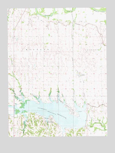
Webber, KS USGS Topographic Map
Click on map above to begin viewing in our Map Viewer.

This topographic map contains these locations and features:
Feature Name Type Latitude Longitude GNIS ID View Map
Bishop (historical)LocaleN39.8847°W98.0217°482266View Map
Cedar Point Recreation AreaParkN39.8983°W98.0439°471888View Map
City of WebberCivilN39.9344°W98.0352°2397240View Map
Johns CreekStreamN39.9008°W98.1059°471892View Map
Lovewell DamDamN39.8903°W98.0267°479855View Map
Lovewell ReservoirReservoirN39.8978°W98.0640°471872View Map
Lovewell State ParkParkN39.9045°W98.0509°471887View Map
Lovewell State Park Cedar Point CampgroundLocaleN39.8977°W98.0477°2624968View Map
Lovewell State Park Cottonwood CampgroundLocaleN39.9017°W98.0487°2624969View Map
Lovewell State Park Pioneer CampgroundLocaleN39.8955°W98.0423°2624970View Map
Lovewell State Park Walleye Point CampgroundLocaleN39.8951°W98.0390°2624971View Map
Lovewell State Park Willow CampgroundLocaleN39.9048°W98.0523°2624972View Map
Lovewell Wildlife AreaParkN39.8903°W98.0267°479775View Map
Montana CemeteryCemeteryN39.9153°W98.1087°471891View Map
Montana CreekStreamN39.9070°W98.1037°471894View Map
Oak Hill Recreation AreaParkN39.8922°W98.0712°471890View Map
Rubens (historical)LocaleN39.9014°W98.0975°481989View Map
Township of MontanaCivilN39.9585°W98.0993°471873View Map
Valley View CemeteryCemeteryN39.9861°W98.0314°2650435View Map
WebberPopulated PlaceN39.9350°W98.0350°471893View Map
Webber CemeteryCemeteryN39.9280°W98.0355°2673290View Map
Webber Post OfficePost OfficeN39.9343°W98.0357°2694014View Map
White Rock Scandinavian Evangelical Lutheran CemeteryCemeteryN39.8992°W98.0434°471889View Map

Note: Coordinates in the location and feature list above are referenced to NAD83 datum.


Copyright (C) 2008-2025 Ryan Niemi / Sunset Dynamics ... All Rights Reserved