TopoQuest Logo
Do you find TopoQuest useful?
Help keep TopoQuest running and adding new maps/features by donating!
Bitcoin:  19c7KJd3qBynnjoSw5npx9KScwjBe4ifkT
Litecoin:  LXs6TkuXGGXo1vDsWCkWVdjQX94eUKd6ui
Home View Maps Find Maps Find Places Resources & Links


Wells SW, Texas Topographic Map

USGS Map Title: Wells SW, TX
USGS Map MRC: 31094C8
DRG (GeoTIFF) Download: o31094c8.tif


Neighboring USGS Topographic Map Quads:


  Kennard NE, TX  
31095D1
 

  Wells, TX  
31094D8
 

  Clawson, TX  
31094D7
 

  Centralia, TX  
31095C1
 

  Wells SW, TX  
31094C8
 

  Keltys, TX  
31094C7
 

  Crecy, TX  
31095B1
 

  Apple Springs, TX  
31094B8
 

  Diboll, TX  
31094B7


Map MRC Location:

N32°
W95°
N32°
W94°
H8 H7 H6 H5 H4 H3 H2 H1
G8 G7 G6 G5 G4 G3 G2 G1
F8 F7 F6 F5 F4 F3 F2 F1
E8 E7 E6 E5 E4 E3 E2 E1
D8 D7 D6 D5 D4 D3 D2 D1
C8 C7 C6 C5 C4 C3 C2 C1
B8 B7 B6 B5 B4 B3 B2 B1
A8 A7 A6 A5 A4 A3 A2 A1
N31°
W95°
N31°
W94°

Wells SW, TX USGS 1:24K Topographic Map Preview:
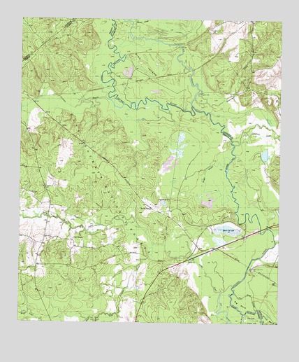
Wells SW, TX USGS Topographic Map
Click on map above to begin viewing in our Map Viewer.

This topographic map contains these locations and features:
Feature Name Type Latitude Longitude GNIS ID View Map
Angelina ClubLocaleN31.3443°W94.9133°1351126View Map
Angelina CLubLocaleN31.3443°W94.9138°1383567View Map
Big BendBendN31.2580°W94.8938°1352016View Map
Big BendGutN31.2619°W94.8902°1352018View Map
Big Bend SloughStreamN31.2557°W94.8855°1383560View Map
Black Cat LakeLakeN31.2885°W94.8997°1383563View Map
Black Cat LakeLakeN31.2893°W94.9004°1352299View Map
Boggy SloughStreamN31.3007°W94.8969°1383562View Map
Boggy SloughGutN31.3116°W94.9105°1352596View Map
Boggy Slough ClubLocaleN31.3010°W94.9280°1383569View Map
Boggy Slough ClubLocaleN31.3010°W94.9274°1352597View Map
Bristow CreekStreamN31.3385°W94.9988°1372724View Map
Bristow CreekStreamN31.3382°W94.9988°1383620View Map
Buncombe CreekStreamN31.3424°W94.9160°1353304View Map
Cedar CreekStreamN31.2652°W94.8969°1385476View Map
Cedar CreekStreamN31.2630°W94.9027°1372137View Map
Cochino BayouStreamN31.3400°W94.9509°1354716View Map
Cole LakeLakeN31.2519°W94.8875°1354765View Map
Crawford CreekStreamN31.3235°W94.8969°1355326View Map
Durham CreekStreamN31.3741°W94.9466°1383551View Map
Eason Lake ClubLocaleN31.2727°W94.8874°1356564View Map
Eason Lake CLubLocaleN31.2738°W94.8869°1383564View Map
Neches ClubLocaleN31.2757°W94.9183°1383561View Map
Neches ClubLocaleN31.2757°W94.9180°1363632View Map
New ChurchChurchN31.2849°W94.9741°1363699View Map
New CHurchChurchN31.2849°W94.9744°1383573View Map
North Cedar AirportAirportN31.2787°W94.9744°2676593View Map
North Fork Cedar CreekStreamN31.2821°W94.9355°1364050View Map
North Fork Cedar CreekStreamN31.2824°W94.9360°1383618View Map
Old ChannelGutN31.3577°W94.9222°1375267View Map
Old RiverStreamN31.2535°W94.8913°1350813View Map
Pine IslandIslandN31.3560°W94.9405°1365291View Map
Pine IslandIslandN31.3716°W94.9374°1383539View Map
Pine Island ClubLocaleN31.3652°W94.9213°1365293View Map
Pine Island ClubLocaleN31.3649°W94.9224°1383600View Map
Pine Ridge ClubLocaleN31.3716°W94.9080°1365307View Map
Pine Ridge ClubLocaleN31.3713°W94.9091°1383566View Map
Raville SidingLocaleN31.2977°W94.9369°1366064View Map
Raville SidingLocaleN31.2982°W94.9399°1383568View Map
Rowan CreekStreamN31.3718°W94.9469°1383552View Map
Rowan CreekStreamN31.3716°W94.9463°1366979View Map
South Fork Cedar CreekStreamN31.2821°W94.9360°1383757View Map
South Fork Cedar CreekStreamN31.2821°W94.9355°1368679View Map
VairPopulated PlaceN31.2810°W94.9135°1379326View Map
VairLocaleN31.2810°W94.9130°1383565View Map
White BranchStreamN31.2538°W94.9524°1383758View Map
White BranchStreamN31.2519°W94.9616°1371354View Map

Note: Coordinates in the location and feature list above are referenced to NAD83 datum.


Copyright (C) 2008-2024 Ryan Niemi / Sunset Dynamics ... All Rights Reserved