TopoQuest Logo
Do you find TopoQuest useful?
Help keep TopoQuest running and adding new maps/features by donating!
Bitcoin:  19c7KJd3qBynnjoSw5npx9KScwjBe4ifkT
Litecoin:  LXs6TkuXGGXo1vDsWCkWVdjQX94eUKd6ui
Home View Maps Find Maps Find Places Resources & Links


Kennard NE, Texas Topographic Map

USGS Map Title: Kennard NE, TX
USGS Map MRC: 31095D1
DRG (GeoTIFF) Download: o31095d1.tif


Neighboring USGS Topographic Map Quads:


  Weches, TX  
31095E2
 

  Forest, TX  
31095E1
 

  Durst Lakes, TX  
31094E8
 

  Ratcliff, TX  
31095D2
 

  Kennard NE, TX  
31095D1
 

  Wells, TX  
31094D8
 

  Kennard, TX  
31095C2
 

  Centralia, TX  
31095C1
 

  Wells SW, TX  
31094C8


Map MRC Location:

N32°
W96°
N32°
W95°
H8 H7 H6 H5 H4 H3 H2 H1
G8 G7 G6 G5 G4 G3 G2 G1
F8 F7 F6 F5 F4 F3 F2 F1
E8 E7 E6 E5 E4 E3 E2 E1
D8 D7 D6 D5 D4 D3 D2 D1
C8 C7 C6 C5 C4 C3 C2 C1
B8 B7 B6 B5 B4 B3 B2 B1
A8 A7 A6 A5 A4 A3 A2 A1
N31°
W96°
N31°
W95°

Kennard NE, TX USGS 1:24K Topographic Map Preview:
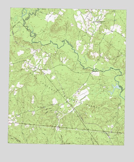
Kennard NE, TX USGS Topographic Map
Click on map above to begin viewing in our Map Viewer.

This topographic map contains these locations and features:
Feature Name Type Latitude Longitude GNIS ID View Map
Anderson CrossingCrossingN31.4152°W95.0619°1377372View Map
Bates Ferry (historical)CrossingN31.4663°W95.0905°1377352View Map
Big SloughStreamN31.4855°W95.1099°1381434View Map
Big Slough WildernessReserveN31.4845°W95.1122°2035052View Map
Conner CreekStreamN31.4252°W95.0183°1354883View Map
Conner Creek School (historical)SchoolN31.4110°W95.0699°1377374View Map
Druso Post Office (historical)Post OfficeN31.3793°W95.0305°1385466View Map
Ernest Anderson CrossingCrossingN31.4435°W95.0358°1377369View Map
Henry U Payne Cotton Gin (historical)BuildingN31.4077°W95.0713°1377375View Map
Hickman BranchStreamN31.4043°W95.0699°1359107View Map
Hickory CreekStreamN31.4846°W95.1105°1383105View Map
John T Collier Syrup and Grist MillBuildingN31.4130°W95.0633°1377373View Map
Kilgore BranchStreamN31.4496°W95.0933°1383118View Map
Kilgore CemeteryCemeteryN31.4055°W95.0552°1377368View Map
Larrison CreekStreamN31.4493°W95.0483°1383122View Map
Lee Anderson Toll Bridge (historical)BridgeN31.4663°W95.0905°1377353View Map
Luce CemeteryCemeteryN31.3877°W95.0391°1377367View Map
Malibu ClubLocaleN31.4280°W95.0216°1362109View Map
Malibu Club DamDamN31.4268°W95.0052°1860725View Map
Malibu Club LakeReservoirN31.4268°W95.0052°1860726View Map
McCombe BranchStreamN31.4191°W95.0030°1362387View Map
McKinleyville (historical)Populated PlaceN31.4616°W95.0977°1377444View Map
McKinney and Wells Family CemeteryCemeteryN31.4493°W95.1133°1377363View Map
Mexican Prisoners GraveCemeteryN31.4524°W95.1113°1377359View Map
Mount VernonPopulated PlaceN31.4085°W95.0874°2034826View Map
Mount Vernon Baptist ChurchChurchN31.4088°W95.0866°1363329View Map
Mount Vernon CemeteryCemeteryN31.4085°W95.0866°1377364View Map
Mouth of Hickory Creek CampgroundLocaleN31.4849°W95.1105°1377454View Map
Nebo School (historical)SchoolN31.4177°W95.0574°1377371View Map
Neff Train Stop (historical)BuildingN31.3785°W95.0141°1377365View Map
Old Brennon School (historical)SchoolN31.4507°W95.1119°1377360View Map
Old Tram Hiking TrailTrailN31.4663°W95.1119°2033321View Map
Owens BranchStreamN31.4066°W95.0772°1364625View Map
Pisgah CemeteryCemeteryN31.3846°W95.0155°1377366View Map
PlainPopulated PlaceN31.4516°W95.1102°2034803View Map
Plain ChurchChurchN31.4518°W95.1102°1365368View Map
Plain Post Office (historical)Post OfficeN31.4663°W95.0905°1385465View Map
Plain School (historical)SchoolN31.4513°W95.1094°1377358View Map
Sandy CreekStreamN31.4888°W95.0355°1382719View Map
Sandy CreekStreamN31.4921°W95.1130°1382720View Map
Shingle Knife Shingle Mill (historical)BuildingN31.4643°W95.0738°1377356View Map
Shooks Bluff CemeteryCemeteryN31.4546°W95.0127°1368223View Map
Shooks Bluff Stagecoach and Mail Route Crossing (historical)CrossingN31.4399°W95.0063°1377370View Map
Sikes CreekStreamN31.4646°W95.0735°1368267View Map
Snake CreekStreamN31.4977°W95.0955°1382781View Map
Sweet UnionPopulated PlaceN31.4891°W95.0302°2034900View Map
Sweet Union ChurchChurchN31.4888°W95.0302°1369472View Map
Thomas Jefferson Payne HomeParkN31.4043°W95.0697°1377453View Map
Walker CemeteryCemeteryN31.4491°W95.1044°1377361View Map
Walker Crossing (historical)CrossingN31.4457°W95.0777°1377362View Map
Wells Elementary SchoolSchoolN31.4888°W95.0302°2004645View Map
Wells SchoolSchoolN31.4888°W95.0302°1371039View Map

Note: Coordinates in the location and feature list above are referenced to NAD83 datum.


Copyright (C) 2008-2024 Ryan Niemi / Sunset Dynamics ... All Rights Reserved