TopoQuest Logo
Do you find TopoQuest useful?
Help keep TopoQuest running and adding new maps/features by donating!
Bitcoin:  19c7KJd3qBynnjoSw5npx9KScwjBe4ifkT
Litecoin:  LXs6TkuXGGXo1vDsWCkWVdjQX94eUKd6ui
Home View Maps Find Maps Find Places Resources & Links


West Line, Missouri Topographic Map

USGS Map Title: West Line, MO
USGS Map MRC: 38094F5
DRG (GeoTIFF) Download: o38094f5.tif


Neighboring USGS Topographic Map Quads:


  Stilwell, KS  
38094G6
 

  Belton, MO  
38094G5
 

  Raymore, MO  
38094G4
 

  Bucyrus, KS  
38094F6
 

  West Line, MO  
38094F5
 

  Peculiar, MO  
38094F4
 

  Louisburg, KS  
38094E6
 

  Freeman, MO  
38094E5
 

  Everett, MO  
38094E4


Map MRC Location:

N39°
W95°
N39°
W94°
H8 H7 H6 H5 H4 H3 H2 H1
G8 G7 G6 G5 G4 G3 G2 G1
F8 F7 F6 F5 F4 F3 F2 F1
E8 E7 E6 E5 E4 E3 E2 E1
D8 D7 D6 D5 D4 D3 D2 D1
C8 C7 C6 C5 C4 C3 C2 C1
B8 B7 B6 B5 B4 B3 B2 B1
A8 A7 A6 A5 A4 A3 A2 A1
N38°
W95°
N38°
W94°

West Line, MO USGS 1:24K Topographic Map Preview:
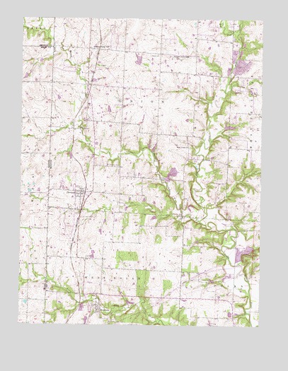
West Line, MO USGS Topographic Map
Click on map above to begin viewing in our Map Viewer.

This topographic map contains these locations and features:
Feature Name Type Latitude Longitude GNIS ID View Map
Al Jurgeson LakeReservoirN38.7332°W94.5646°763427View Map
Al Jurgeson Lake DamDamN38.7333°W94.5636°763426View Map
Bartlett Lake DamDamN38.6683°W94.5552°763221View Map
Belton Wastewater Treatment FacilityLocaleN38.7379°W94.5070°2477708View Map
Brownville School (historical)SchoolN38.6475°W94.5411°729851View Map
Cass County Midway Wastewater Treatment FacilityLocaleN38.6351°W94.5390°2477713View Map
City of ClevelandCivilN38.6788°W94.5980°2393561View Map
City of Lake AnnetteCivilN38.6544°W94.5081°2395585View Map
ClevelandPopulated PlaceN38.6792°W94.5936°729862View Map
Cleveland CemeteryCemeteryN38.6900°W94.5797°715966View Map
Cleveland Post OfficePost OfficeN38.6790°W94.5932°2779507View Map
Cleveland School (historical)SchoolN38.6800°W94.5905°745917View Map
Corinth CemeteryCemeteryN38.7047°W94.5952°716311View Map
Dolan - West Dolan Fire Protection District Station 2BuildingN38.6279°W94.5873°2620557View Map
East CreekStreamN38.6675°W94.5319°729878View Map
Frazee CemeteryCemeteryN38.7353°W94.5544°718181View Map
Freeman Water Supply Lake DamDamN38.6267°W94.5019°763551View Map
Glenwild CemeteryCemeteryN38.6522°W94.5902°718521View Map
Kurzweil LakeReservoirN38.6298°W94.5155°763345View Map
Kurzweil Lake DamDamN38.6283°W94.5152°763344View Map
Lake AnnettePopulated PlaceN38.6542°W94.5083°1669604View Map
Lake AnnetteReservoirN38.6500°W94.5119°763144View Map
Lake Annette DamDamN38.6500°W94.5119°763143View Map
Massey CreekStreamN38.6678°W94.5319°721963View Map
Midway Elementary SchoolSchoolN38.6352°W94.5394°2545075View Map
Midway High SchoolSchoolN38.6351°W94.5386°2545108View Map
Pleasant Prairie School (historical)SchoolN38.7347°W94.5383°724577View Map
Pleasant Valley School (historical)SchoolN38.7378°W94.5877°724628View Map
Powell (historical)LocaleN38.7164°W94.5908°759575View Map
Riverview EstatesPopulated PlaceN38.7496°W94.5272°2417409View Map
Township of UnionCivilN38.7142°W94.5634°766446View Map
Veach FieldAirportN38.6258°W94.5211°2717168View Map
Village of Riverview EstatesCivilN38.7489°W94.5246°2417410View Map
Village of West LineCivilN38.6357°W94.5870°2400136View Map
Wells LakeReservoirN38.7060°W94.5171°763343View Map
Wells Lake DamDamN38.7050°W94.5202°763342View Map
West Fork East CreekStreamN38.7453°W94.5122°728563View Map
West LinePopulated PlaceN38.6322°W94.5841°729983View Map
West Line School (historical)SchoolN38.6311°W94.5847°745918View Map
West Union (historical)LocaleN38.6964°W94.5383°745629View Map
West Union ChurchChurchN38.6978°W94.5377°729984View Map
West Union School (historical)SchoolN38.6953°W94.5380°745916View Map
Western Cass Fire Protection District Station 96BuildingN38.6787°W94.5909°2620910View Map
Western Cass Fire Protection District Station 97BuildingN38.7451°W94.5337°2620522View Map
Williams AirportAirportN38.7132°W94.5868°758639View Map

Note: Coordinates in the location and feature list above are referenced to NAD83 datum.


Copyright (C) 2008-2025 Ryan Niemi / Sunset Dynamics ... All Rights Reserved