TopoQuest Logo
Do you find TopoQuest useful?
Help keep TopoQuest running and adding new maps/features by donating!
Bitcoin:  19c7KJd3qBynnjoSw5npx9KScwjBe4ifkT
Litecoin:  LXs6TkuXGGXo1vDsWCkWVdjQX94eUKd6ui
Home View Maps Find Maps Find Places Resources & Links


Glenfield, New York Topographic Map

USGS Map Title: Glenfield, NY
USGS Map MRC: 43075F4
DRG (GeoTIFF) Download: o43075f4.tif


Neighboring USGS Topographic Map Quads:


  West Lowville, NY  
43075G5
 

  Lowville, NY  
43075G4
 

  Crystal Dale, NY  
43075G3
 

  Page, NY  
43075F5
 

  Glenfield, NY  
43075F4
 

  Brantingham, NY  
43075F3
 

  High Market, NY  
43075E5
 

  Constableville, NY  
43075E4
 

  Port Leyden, NY  
43075E3


Map MRC Location:

N44°
W76°
N44°
W75°
H8 H7 H6 H5 H4 H3 H2 H1
G8 G7 G6 G5 G4 G3 G2 G1
F8 F7 F6 F5 F4 F3 F2 F1
E8 E7 E6 E5 E4 E3 E2 E1
D8 D7 D6 D5 D4 D3 D2 D1
C8 C7 C6 C5 C4 C3 C2 C1
B8 B7 B6 B5 B4 B3 B2 B1
A8 A7 A6 A5 A4 A3 A2 A1
N43°
W76°
N43°
W75°

Glenfield, NY USGS 1:24K Topographic Map Preview:
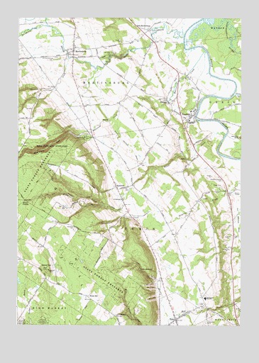
Glenfield, NY USGS Topographic Map
Click on map above to begin viewing in our Map Viewer.

This topographic map contains these locations and features:
Feature Name Type Latitude Longitude GNIS ID View Map
3G Volunteer Fire Company Glenfield Station 1BuildingN43.7201°W75.3991°2735140View Map
Atwater CreekStreamN43.7334°W75.4716°942683View Map
Burdicks Crossing CemeteryCemeteryN43.6839°W75.3851°945204View Map
Carpenter CemeteryCemeteryN43.6647°W75.4684°969963View Map
Collinsville CemeteryCemeteryN43.6265°W75.3937°947164View Map
Deerlick RockPillarN43.7015°W75.3752°948248View Map
East MartinsburgPopulated PlaceN43.7448°W75.4274°972423View Map
Gen Martin High SchoolSchoolN43.7084°W75.4038°950980View Map
GlendalePopulated PlaceN43.7162°W75.4166°951201View Map
GlenfieldPopulated PlaceN43.7103°W75.4021°951212View Map
Glenfield Sewage Treatment PlantLocaleN43.7182°W75.3964°2617726View Map
Gomer HillSummitN43.6509°W75.4857°951305View Map
HosevillePopulated PlaceN43.6815°W75.4446°972628View Map
House CreekStreamN43.7026°W75.3835°953294View Map
Independence RiverStreamN43.7498°W75.3949°953620View Map
Marks FarmsLocaleN43.7467°W75.4272°2703219View Map
MartinsburgPopulated PlaceN43.7376°W75.4696°956600View Map
Martinsburg CemeteryCemeteryN43.7336°W75.4792°959293View Map
Martinsburg Volunteer Fire DepartmentBuildingN43.7380°W75.4679°2718529View Map
Otter CreekStreamN43.7192°W75.3782°959566View Map
Roaring BrookStreamN43.7426°W75.4077°962637View Map
Saint Hedwigs ChurchChurchN43.6767°W75.4416°963538View Map
South Lewis High SchoolSchoolN43.6359°W75.3946°965806View Map
South Lewis Methodist ChurchChurchN43.6286°W75.4090°2616274View Map
South Lewis Middle SchoolSchoolN43.6362°W75.3947°2669187View Map
Tabolt CornersLocaleN43.6756°W75.4952°966982View Map
Town of TurinCivilN43.6640°W75.4294°979562View Map
TurinPopulated PlaceN43.6273°W75.4113°967950View Map
Turin CemeteryCemeteryN43.6334°W75.3982°967951View Map
Turin Fire Volunteer Fire CompanyBuildingN43.6295°W75.4125°2718488View Map
Turin Highlands Golf CourseLocaleN43.6412°W75.4038°2615078View Map
Turin ReservoirReservoirN43.6479°W75.4313°967952View Map
Valley Brook Drive-InLocaleN43.6786°W75.3792°2558356View Map
Village of TurinCivilN43.6292°W75.4107°2391172View Map
Welch HillPopulated PlaceN43.6362°W75.4605°973215View Map
Whetstone CreekStreamN43.7365°W75.3957°971029View Map
Whetstone GulfValleyN43.7034°W75.4607°971030View Map
Whetstone Gulf State ParkParkN43.6984°W75.4832°971031View Map
Whitaker FallsFallsN43.7344°W75.4456°2786774View Map
Whittaker Falls ParkParkN43.7356°W75.4493°971198View Map

Note: Coordinates in the location and feature list above are referenced to NAD83 datum.


Copyright (C) 2008-2025 Ryan Niemi / Sunset Dynamics ... All Rights Reserved