TopoQuest Logo
Do you find TopoQuest useful?
Help keep TopoQuest running and adding new maps/features by donating!
Bitcoin:  19c7KJd3qBynnjoSw5npx9KScwjBe4ifkT
Litecoin:  LXs6TkuXGGXo1vDsWCkWVdjQX94eUKd6ui
Home View Maps Find Maps Find Places Resources & Links


West Mansfield, Ohio Topographic Map

USGS Map Title: West Mansfield, OH
USGS Map MRC: 40083D5
DRG (GeoTIFF) Download: o40083d5.tif


Neighboring USGS Topographic Map Quads:


  Silver Creek, OH  
40083E6
 

  Mount Victory, OH  
40083E5
 

  La Rue, OH  
40083E4
 

  Rushsylvania, OH  
40083D6
 

  West Mansfield, OH  
40083D5
 

  York Center, OH  
40083D4
 

  Zanesfield, OH  
40083C6
 

  East Liberty, OH  
40083C5
 

  Peoria, OH  
40083C4


Map MRC Location:

N41°
W84°
N41°
W83°
H8 H7 H6 H5 H4 H3 H2 H1
G8 G7 G6 G5 G4 G3 G2 G1
F8 F7 F6 F5 F4 F3 F2 F1
E8 E7 E6 E5 E4 E3 E2 E1
D8 D7 D6 D5 D4 D3 D2 D1
C8 C7 C6 C5 C4 C3 C2 C1
B8 B7 B6 B5 B4 B3 B2 B1
A8 A7 A6 A5 A4 A3 A2 A1
N40°
W84°
N40°
W83°

West Mansfield, OH USGS 1:24K Topographic Map Preview:
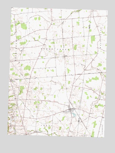
West Mansfield, OH USGS Topographic Map
Click on map above to begin viewing in our Map Viewer.

This topographic map contains these locations and features:
Feature Name Type Latitude Longitude GNIS ID View Map
Bell School (historical)SchoolN40.4303°W83.5974°1053559View Map
Benjamin Logan Elementary SchoolSchoolN40.4053°W83.5469°1055013View Map
Bethany School (historical)SchoolN40.4895°W83.5166°1055580View Map
Bethel ChurchChurchN40.4126°W83.5099°1064429View Map
Bethel School (historical)SchoolN40.4162°W83.5083°1055581View Map
Bokescreek Township Fire DepartmentBuildingN40.3992°W83.5453°2549870View Map
Camp MacocheeLocaleN40.3989°W83.6238°1038719View Map
Centennial School (historical)SchoolN40.4448°W83.5416°1053561View Map
Early CemeteryCemeteryN40.4901°W83.5545°1039931View Map
Good Hope CemeteryCemeteryN40.4700°W83.5793°1040941View Map
Good Hope School (historical)SchoolN40.4698°W83.5791°1053562View Map
Hathaway CemeteryCemeteryN40.4156°W83.5446°1041397View Map
Heartland Quality Egg FarmLocaleN40.4297°W83.5664°2630944View Map
HortonPopulated PlaceN40.4531°W83.5549°1064866View Map
Horton Post Office (historical)Post OfficeN40.4528°W83.5555°2026319View Map
North GreenfieldPopulated PlaceN40.3776°W83.5894°1065167View Map
North Greenfield CemeteryCemeteryN40.3762°W83.5997°1043950View Map
North Greenfield Post Office (historical)Post OfficeN40.3778°W83.5888°2026325View Map
Pullet FarmLocaleN40.3814°W83.5536°2630943View Map
Quaker CemeteryCemeteryN40.4987°W83.5190°1044813View Map
Quaking Asp School (historical)SchoolN40.4723°W83.5455°1053564View Map
School Number 10 (historical)SchoolN40.4428°W83.5652°1053560View Map
Southard CemeteryCemeteryN40.3981°W83.5194°1046500View Map
Township of BokescreekCivilN40.4557°W83.5672°1086482View Map
Village of West MansfieldCivilN40.4007°W83.5444°2400138View Map
Walnut GrovePopulated PlaceN40.4273°W83.6233°1065449View Map
Walnutgrove Post Office (historical)Post OfficeN40.4278°W83.6235°2026289View Map
West MansfieldPopulated PlaceN40.4020°W83.5452°1061743View Map
West Mansfield Baptist ChurchChurchN40.4042°W83.5477°1060810View Map
West Mansfield Post OfficePost OfficeN40.4014°W83.5458°2026333View Map
West Mansfield United Methodist ChurchChurchN40.4020°W83.5433°1060811View Map
White Swan School (historical)SchoolN40.4914°W83.5724°1053563View Map

Note: Coordinates in the location and feature list above are referenced to NAD83 datum.


Copyright (C) 2008-2024 Ryan Niemi / Sunset Dynamics ... All Rights Reserved