TopoQuest Logo
Do you find TopoQuest useful?
Help keep TopoQuest running and adding new maps/features by donating!
Bitcoin:  19c7KJd3qBynnjoSw5npx9KScwjBe4ifkT
Litecoin:  LXs6TkuXGGXo1vDsWCkWVdjQX94eUKd6ui
Home View Maps Find Maps Find Places Resources & Links


York Center, Ohio Topographic Map

USGS Map Title: York Center, OH
USGS Map MRC: 40083D4
DRG (GeoTIFF) Download: o40083d4.tif


Neighboring USGS Topographic Map Quads:


  Mount Victory, OH  
40083E5
 

  La Rue, OH  
40083E4
 

  New Bloomington, OH  
40083E3
 

  West Mansfield, OH  
40083D5
 

  York Center, OH  
40083D4
 

  Richwood, OH  
40083D3
 

  East Liberty, OH  
40083C5
 

  Peoria, OH  
40083C4
 

  Magnetic Springs, OH  
40083C3


Map MRC Location:

N41°
W84°
N41°
W83°
H8 H7 H6 H5 H4 H3 H2 H1
G8 G7 G6 G5 G4 G3 G2 G1
F8 F7 F6 F5 F4 F3 F2 F1
E8 E7 E6 E5 E4 E3 E2 E1
D8 D7 D6 D5 D4 D3 D2 D1
C8 C7 C6 C5 C4 C3 C2 C1
B8 B7 B6 B5 B4 B3 B2 B1
A8 A7 A6 A5 A4 A3 A2 A1
N40°
W84°
N40°
W83°

York Center, OH USGS 1:24K Topographic Map Preview:
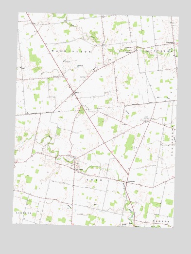
York Center, OH USGS Topographic Map
Click on map above to begin viewing in our Map Viewer.

This topographic map contains these locations and features:
Feature Name Type Latitude Longitude GNIS ID View Map
ArbelaPopulated PlaceN40.4817°W83.4069°1055573View Map
Arbela Post OfficePost OfficeN40.4819°W83.4069°2074217View Map
Beechdale School (historical)SchoolN40.4234°W83.4699°1055578View Map
Bolenbaugh School (historical)SchoolN40.4348°W83.4388°1055588View Map
Brush RunStreamN40.3767°W83.4069°1038425View Map
Burnside CemeteryCemeteryN40.4811°W83.4110°1038543View Map
ByhaliaPopulated PlaceN40.4537°W83.4555°1048573View Map
Byhalia CemeteryCemeteryN40.4634°W83.4671°1038586View Map
Byhalia Post Office (historical)Post OfficeN40.4536°W83.4553°2074265View Map
Cahill School (historical)SchoolN40.3903°W83.4752°1055593View Map
Camp UnionLocaleN40.4295°W83.4552°1038759View Map
Day Lay Egg FarmLocaleN40.3808°W83.4519°2677544View Map
East York CemeteryCemeteryN40.4381°W83.4002°1040027View Map
Fountain Grove School (historical)SchoolN40.4687°W83.3855°1055606View Map
Fouts School (historical)SchoolN40.4398°W83.4924°1055608View Map
Grace ChapelChurchN40.4781°W83.4113°1040997View Map
Grace Temple School (historical)SchoolN40.4776°W83.4113°1055609View Map
Haynesville (historical)Populated PlaceN40.4817°W83.4341°1067257View Map
Howard School (historical)SchoolN40.4987°W83.4383°1055612View Map
Mad River Egg FarmLocaleN40.3928°W83.4517°2725570View Map
Merit School (historical)SchoolN40.4839°W83.3799°1055633View Map
Middle Branch Bokes CreekStreamN40.4214°W83.4938°1067258View Map
Middleton School (historical)SchoolN40.3789°W83.4535°1055629View Map
Miller School (historical)SchoolN40.4384°W83.3955°1055631View Map
Pleasant Valley School (historical)SchoolN40.3842°W83.4308°1055640View Map
Powder Lick RunStreamN40.3851°W83.4119°1066150View Map
Rocky ForkStreamN40.4773°W83.4216°1066175View Map
Sherwood School (historical)SchoolN40.4776°W83.4758°1055647View Map
Sommersville CemeteryCemeteryN40.3976°W83.4133°1961365View Map
SummersvillePopulated PlaceN40.4001°W83.4110°1061661View Map
Township of WashingtonCivilN40.4727°W83.4644°1087085View Map
Township of YorkCivilN40.4081°W83.4508°1087086View Map
Union Baptist ChurchChurchN40.4831°W83.3855°1955552View Map
Washington Township HallBuildingN40.4564°W83.4583°1955560View Map
West JacksonPopulated PlaceN40.4842°W83.3785°1047768View Map
Wilderness School (historical)SchoolN40.4948°W83.4966°1055669View Map
York CenterPopulated PlaceN40.4078°W83.4533°1061808View Map
York Center CemeteryCemeteryN40.4117°W83.4544°1961366View Map

Note: Coordinates in the location and feature list above are referenced to NAD83 datum.


Copyright (C) 2008-2025 Ryan Niemi / Sunset Dynamics ... All Rights Reserved