TopoQuest Logo
Do you find TopoQuest useful?
Help keep TopoQuest running and adding new maps/features by donating!
Bitcoin:  19c7KJd3qBynnjoSw5npx9KScwjBe4ifkT
Litecoin:  LXs6TkuXGGXo1vDsWCkWVdjQX94eUKd6ui
Home View Maps Find Maps Find Places Resources & Links


West Salem, Illinois Topographic Map

USGS Map Title: West Salem, IL
USGS Map MRC: 38088E1
DRG (GeoTIFF) Download: o38088e1.tif


Neighboring USGS Topographic Map Quads:


  Noble, IL  
38088F2
 

  Olney, IL  
38088F1
 

  Claremont, IL  
38087F8
 

  Mount Erie, IL  
38088E2
 

  West Salem, IL  
38088E1
 

  Berryville, IL  
38087E8
 

  Albion NW, IL  
38088D2
 

  Albion North, IL  
38088D1
 

  Bone Gap, IL  
38087D8


Map MRC Location:

N39°
W89°
N39°
W88°
H8 H7 H6 H5 H4 H3 H2 H1
G8 G7 G6 G5 G4 G3 G2 G1
F8 F7 F6 F5 F4 F3 F2 F1
E8 E7 E6 E5 E4 E3 E2 E1
D8 D7 D6 D5 D4 D3 D2 D1
C8 C7 C6 C5 C4 C3 C2 C1
B8 B7 B6 B5 B4 B3 B2 B1
A8 A7 A6 A5 A4 A3 A2 A1
N38°
W89°
N38°
W88°

West Salem, IL USGS 1:24K Topographic Map Preview:
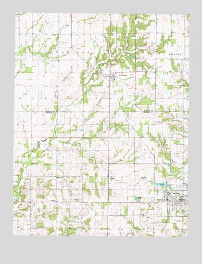
West Salem, IL USGS Topographic Map
Click on map above to begin viewing in our Map Viewer.

This topographic map contains these locations and features:
Feature Name Type Latitude Longitude GNIS ID View Map
Alfred School (historical)SchoolN38.5045°W88.0945°1725209View Map
Bare CreekStreamN38.5717°W88.0931°403898View Map
Bethel CemeteryCemeteryN38.6123°W88.0981°404270View Map
Bethel Church (historical)SchoolN38.6128°W88.0984°1736782View Map
Brown CemeteryCemeteryN38.5667°W88.0575°1725211View Map
Brown School (historical)SchoolN38.5339°W88.0567°1725212View Map
Center School (historical)SchoolN38.5995°W88.0934°1736790View Map
Ely CemeteryCemeteryN38.5034°W88.1189°407978View Map
Ensor School (historical)SchoolN38.6248°W88.0620°1736799View Map
Evangelical CemeteryCemeteryN38.5220°W88.0125°1808149View Map
Grass Valley School (historical)SchoolN38.6148°W88.0242°1736805View Map
Greathouse CemeteryCemeteryN38.5006°W88.0431°409364View Map
Greathouse CemeteryCemeteryN38.5117°W88.0309°409365View Map
Harrison LakeReservoirN38.5408°W88.0147°1691114View Map
Harrison Lake DamDamN38.5400°W88.0117°1691113View Map
Harrison School (historical)SchoolN38.5787°W88.0236°1736806View Map
Hedrick School (historical)SchoolN38.5403°W88.0034°1725215View Map
Johnson CreekStreamN38.5534°W88.0786°411162View Map
Jones DitchCanalN38.6239°W88.1209°411213View Map
Krajec LakeReservoirN38.5210°W88.0366°411618View Map
Krajec Lake DamDamN38.5212°W88.0367°1691115View Map
Little Wabash CemeteryCemeteryN38.5034°W88.1123°1808158View Map
Little Wabash Zion United Methodist ChurchChurchN38.5037°W88.1117°412429View Map
Lone Oak School (historical)SchoolN38.5698°W88.1025°1736811View Map
Long Prairie Primitive Baptist ChurchChurchN38.5187°W88.0756°412602View Map
Macedonia CemeteryCemeteryN38.5187°W88.0948°412789View Map
Madden CreekStreamN38.5548°W88.0978°412819View Map
Maple GrovePopulated PlaceN38.5334°W88.0939°422935View Map
MarionPopulated PlaceN38.5512°W88.1084°1808160View Map
Marion CemeteryCemeteryN38.5509°W88.1084°1808161View Map
Marion Christian ChurchChurchN38.5509°W88.1075°1725475View Map
Mason School (historical)SchoolN38.5700°W88.0575°1736812View Map
Moravian CemeteryCemeteryN38.5214°W88.0009°413805View Map
Oak Grove School (historical)SchoolN38.5995°W88.0042°1736817View Map
Oak Hill CemeteryCemeteryN38.5928°W88.0639°414817View Map
Parker CreekStreamN38.5548°W88.0936°415395View Map
ParkersburgPopulated PlaceN38.5898°W88.0567°415402View Map
Parkersburg Oil FieldOilfieldN38.5578°W88.0109°425309View Map
Parkersburg Post OfficePost OfficeN38.5899°W88.0567°2788737View Map
Salem Election Precinct (historical)CivilN38.5284°W88.0056°1928638View Map
Salem Number 2 Election PrecinctCivilN38.5273°W88.0314°1928640View Map
Seventh Day Adventist CemeteryCemeteryN38.5192°W88.0034°1808174View Map
Shelby CreekStreamN38.5406°W88.1186°418333View Map
Shelby Number 1 Election PrecinctCivilN38.5332°W88.1024°1928645View Map
Township of MadisonCivilN38.6137°W88.0859°429307View Map
Village of ParkersburgCivilN38.5891°W88.0568°2399624View Map
Village of West SalemCivilN38.5197°W88.0090°2400144View Map
West SalemPopulated PlaceN38.5209°W88.0048°420909View Map
West Salem Airport (historical)AirportN38.5334°W88.0339°1725476View Map
West Salem City HallBuildingN38.5197°W88.0044°2680924View Map
West Salem Fire Department First RespondersBuildingN38.5199°W88.0043°2681990View Map
West Salem Grade SchoolSchoolN38.5228°W88.0042°1808178View Map
West Salem New ReservoirReservoirN38.5290°W88.0156°1692077View Map
West Salem New Reservoir DamDamN38.5284°W88.0150°1692076View Map
West Salem Police DepartmentBuildingN38.5201°W88.0042°2759059View Map
West Salem Post OfficePost OfficeN38.5213°W88.0039°2788719View Map
West Salem ReservoirReservoirN38.5295°W88.0197°420910View Map
Zion School (historical)SchoolN38.6200°W88.1223°1736846View Map

Note: Coordinates in the location and feature list above are referenced to NAD83 datum.


Copyright (C) 2008-2024 Ryan Niemi / Sunset Dynamics ... All Rights Reserved