TopoQuest Logo
Do you find TopoQuest useful?
Help keep TopoQuest running and adding new maps/features by donating!
Bitcoin:  19c7KJd3qBynnjoSw5npx9KScwjBe4ifkT
Litecoin:  LXs6TkuXGGXo1vDsWCkWVdjQX94eUKd6ui
Home View Maps Find Maps Find Places Resources & Links


Wheeler, Virginia Topographic Map

USGS Map Title: Wheeler, VA
USGS Map MRC: 36083E5
DRG (GeoTIFF) Download: o36083e5.tif


Neighboring USGS Topographic Map Quads:


  Middlesboro North, KY  
36083F6
 

  Varilla, KY  
36083F5
 

  Ewing, VA  
36083F4
 

  Middlesboro South, KY  
36083E6
 

  Wheeler, VA  
36083E5
 

  Coleman Gap, TN  
36083E4
 

  Clouds, TN  
36083D6
 

  Tazewell, TN  
36083D5
 

  Howard Quarter, TN  
36083D4


Map MRC Location:

N37°
W84°
N37°
W83°
H8 H7 H6 H5 H4 H3 H2 H1
G8 G7 G6 G5 G4 G3 G2 G1
F8 F7 F6 F5 F4 F3 F2 F1
E8 E7 E6 E5 E4 E3 E2 E1
D8 D7 D6 D5 D4 D3 D2 D1
C8 C7 C6 C5 C4 C3 C2 C1
B8 B7 B6 B5 B4 B3 B2 B1
A8 A7 A6 A5 A4 A3 A2 A1
N36°
W84°
N36°
W83°

Wheeler, VA USGS 1:24K Topographic Map Preview:
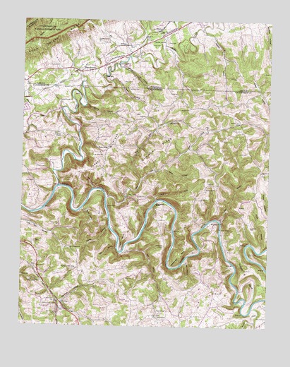
Wheeler, VA USGS Topographic Map
Click on map above to begin viewing in our Map Viewer.

This topographic map contains these locations and features:
Feature Name Type Latitude Longitude GNIS ID View Map
Allen Mill (historical)LocaleN36.5437°W83.5299°1317019View Map
Arnold CemeteryCemeteryN36.6082°W83.5663°1462555View Map
BacchusPopulated PlaceN36.5092°W83.6038°1314613View Map
Bacchus HollowValleyN36.5099°W83.6045°1276044View Map
Bacchus School (historical)SchoolN36.5120°W83.5999°1317088View Map
Barnes HollowValleyN36.6060°W83.5759°1276356View Map
Bee BranchStreamN36.6106°W83.5710°1474226View Map
Bee HollowValleyN36.5319°W83.5765°1276775View Map
Bethel Baptist ChurchChurchN36.5143°W83.5263°1305152View Map
Big Spring HollowValleyN36.5897°W83.5935°1277418View Map
Blair Creek ChurchChurchN36.5179°W83.6152°1305279View Map
Brittian CemeteryCemeteryN36.5887°W83.5405°1278419View Map
Brooks CemeteryCemeteryN36.5804°W83.5143°1278478View Map
Bussell FordCrossingN36.5490°W83.5821°1314778View Map
Campbell CemeteryCemeteryN36.5106°W83.5116°1279441View Map
Campbell FordCrossingN36.5098°W83.5110°1310693View Map
Caney HollowValleyN36.5402°W83.5804°1279588View Map
Canoe BranchStreamN36.5431°W83.5246°1279618View Map
Cave SpringPopulated PlaceN36.5048°W83.5566°1314804View Map
Cave SpringSpringN36.5065°W83.5555°1279958View Map
Cave Spring CreekStreamN36.5304°W83.5738°1310698View Map
Cave Springs Baptist ChurchChurchN36.5037°W83.5557°1644771View Map
Cedar Fork CreekStreamN36.5020°W83.5063°1280023View Map
Cedar Fork ValleyValleyN36.5015°W83.5013°1310699View Map
Chadwell CemeteryCemeteryN36.5759°W83.5235°1280188View Map
Colson CemeteryCemeteryN36.6154°W83.5560°1465121View Map
Commissioner District 5CivilN36.5645°W83.5168°2464429View Map
Commissioner District 6CivilN36.5502°W83.6153°2464518View Map
Cook CemeteryCemeteryN36.5195°W83.5716°1281118View Map
Cosby BridgeBridgeN36.5401°W83.5241°1281338View Map
Cosby CemeteryCemeteryN36.5309°W83.5199°1281339View Map
Cosby CemeteryCemeteryN36.5520°W83.5341°1281340View Map
Cosby CemeteryCemeteryN36.5581°W83.5313°1281341View Map
Cosby FordCrossingN36.5404°W83.5244°1310702View Map
Crain CemeteryCemeteryN36.5526°W83.5624°1281553View Map
Crocket Furnace (historical)LocaleN36.5881°W83.6055°1317037View Map
Cumberland Gap Division (historical)CensusN36.5729°W83.5832°1648644View Map
Dixon CemeteryCemeteryN36.5776°W83.5416°1282520View Map
Double S BendBendN36.5218°W83.5121°1282696View Map
Ellison BendBendN36.5351°W83.5738°1283698View Map
Ellison CemeteryCemeteryN36.5415°W83.6066°1283702View Map
Ellison Mill (historical)LocaleN36.5551°W83.5830°1317042View Map
England CemeteryCemeteryN36.5340°W83.6185°1283785View Map
Ensor CemeteryCemeteryN36.6162°W83.5521°1466320View Map
Fergerson School (historical)SchoolN36.5179°W83.5532°1317044View Map
Flemon CemeteryCemeteryN36.5648°W83.6174°1284464View Map
Forge RidgePopulated PlaceN36.5729°W83.5802°1284611View Map
Forge RidgeRidgeN36.5706°W83.5824°1284613View Map
Forge Ridge Baptist ChurchChurchN36.5743°W83.5794°1644781View Map
Forge Ridge CemeteryCemeteryN36.5695°W83.5835°1284614View Map
Forge Ridge High School (historical)SchoolN36.5734°W83.5802°1644782View Map
Freeman CemeteryCemeteryN36.5081°W83.6132°1284889View Map
Fulton School (historical)SchoolN36.5837°W83.5535°1317046View Map
Furgerson ChapelChurchN36.5329°W83.5524°1285042View Map
Furgerson RidgeRidgeN36.5279°W83.5535°1647383View Map
Gibson CemeteryCemeteryN36.6105°W83.5697°1467062View Map
Gibson CemeteryCemeteryN36.6159°W83.5852°1467063View Map
Gibson MillPopulated PlaceN36.6062°W83.5760°1499469View Map
Gibson PondLakeN36.6173°W83.5869°1467074View Map
Gibson StationLocaleN36.6209°W83.5569°1467076View Map
Gibson StationPopulated PlaceN36.6043°W83.5974°1499470View Map
Grassy HollowValleyN36.5046°W83.5427°1647385View Map
Greers ChapelChurchN36.5781°W83.6077°1286228View Map
Greers School (historical)SchoolN36.5784°W83.6088°1317048View Map
Hammock CemeteryCemeteryN36.5973°W83.5719°1286678View Map
Highland View SchoolSchoolN36.5240°W83.5974°1287763View Map
Hines HollowValleyN36.5313°W83.5048°1287886View Map
Horse HollowValleyN36.5266°W83.5422°1288405View Map
Indian CreekStreamN36.5573°W83.6063°1269671View Map
Indian Creek ChurchChurchN36.5920°W83.6063°1288975View Map
Island CreekStreamN36.5515°W83.5569°1289083View Map
Jack Nance IslandIslandN36.5501°W83.5571°1289159View Map
Jones CemeteryCemeteryN36.5998°W83.5741°1468819View Map
Keck HollowValleyN36.5998°W83.5802°1289933View Map
Kelly CemeteryCemeteryN36.5856°W83.5630°1290029View Map
Lambert CemeteryCemeteryN36.5459°W83.5877°1290553View Map
Liford CemeteryCemeteryN36.5709°W83.5107°1291259View Map
Little CreekPopulated PlaceN36.5526°W83.5727°1315414View Map
Little CreekStreamN36.5523°W83.5821°1291454View Map
Little Creek Baptist ChurchChurchN36.5540°W83.5719°1644795View Map
Little Creek School (historical)SchoolN36.5531°W83.5727°1317056View Map
Littrell CemeteryCemeteryN36.5948°W83.5469°1291727View Map
Long CemeteryCemeteryN36.5237°W83.5085°1291927View Map
Machine BranchStreamN36.6215°W83.5355°1292437View Map
Machine BranchStreamN36.6215°W83.5349°1469984View Map
Massengill BendBendN36.5287°W83.5446°1292897View Map
Mill HollowValleyN36.5302°W83.5739°1293881View Map
Mount Gilead ChurchChurchN36.5831°W83.5507°1294617View Map
Mount Pleasant ChurchChurchN36.5323°W83.6005°1294778View Map
Nash MillPopulated PlaceN36.6020°W83.5832°1499787View Map
North Claiborne Volunteer Fire Department Station 1BuildingN36.5745°W83.5780°2654548View Map
Ownes CemeteryCemeteryN36.5109°W83.6116°1296617View Map
Parks CemeteryCemeteryN36.5437°W83.5555°1296852View Map
Pendleton BranchStreamN36.6115°W83.5663°1472183View Map
Pine Hill School (historical)SchoolN36.5379°W83.6091°1317066View Map
Pines CreekStreamN36.5312°W83.5052°1310722View Map
Poplar GrovePopulated PlaceN36.5562°W83.5321°1315759View Map
Poplar Grove Missionary Baptist ChurchChurchN36.5556°W83.5319°1644807View Map
Poplar Grove School (historical)SchoolN36.5576°W83.5321°1317067View Map
Ridgedale School (historical)SchoolN36.5576°W83.6174°1317074View Map
RiversidePopulated PlaceN36.5412°W83.5235°1647394View Map
Riverside ChurchChurchN36.5426°W83.5232°1299522View Map
Riverside School (historical)SchoolN36.5440°W83.5238°1317077View Map
Rob Camp (historical)LocaleN36.5320°W83.6185°1644816View Map
Russell CreekStreamN36.5079°W83.5071°1300328View Map
Simmons RidgeRidgeN36.5737°W83.5557°1270322View Map
Southern CemeteryCemeteryN36.5972°W83.5995°1270920View Map
Spice HollowValleyN36.5646°W83.5543°1270993View Map
Sproles CemeteryCemeteryN36.5967°W83.5363°1271152View Map
Station CreekStreamN36.5887°W83.6052°1271281View Map
Station CreekStreamN36.5962°W83.6249°1475093View Map
Steep Gut HollowValleyN36.5559°W83.5889°1271313View Map
Sugar HollowValleyN36.5478°W83.5944°1271695View Map
Thomas Walker Volunteer Fire Department Station 2BuildingN36.6092°W83.5780°2768995View Map
Walnut HillSummitN36.6181°W83.5613°1500272View Map
Walnut Hill ChurchChurchN36.6168°W83.5594°1476281View Map
Walnut Hill School (historical)SchoolN36.6140°W83.5660°1496581View Map
West Fork Little CreekStreamN36.5598°W83.5644°1274153View Map
WheelerPopulated PlaceN36.6220°W83.5552°1500308View Map
Wheeler HollowValleyN36.6244°W83.5027°1476555View Map
Willis CemeteryCemeteryN36.5215°W83.6085°1274740View Map
Willis CemeteryCemeteryN36.5240°W83.6166°1274741View Map
Woodson CemeteryCemeteryN36.6062°W83.6116°1476973View Map
Wylie CemeteryCemeteryN36.5240°W83.6185°1275202View Map
Wylie SchoolSchoolN36.5206°W83.6238°1275203View Map
Yellow Shoals FordCrossingN36.5301°W83.5105°1275286View Map

Note: Coordinates in the location and feature list above are referenced to NAD83 datum.


Copyright (C) 2008-2024 Ryan Niemi / Sunset Dynamics ... All Rights Reserved