TopoQuest Logo
Do you find TopoQuest useful?
Help keep TopoQuest running and adding new maps/features by donating!
Bitcoin:  19c7KJd3qBynnjoSw5npx9KScwjBe4ifkT
Litecoin:  LXs6TkuXGGXo1vDsWCkWVdjQX94eUKd6ui
Home View Maps Find Maps Find Places Resources & Links


Wheeler Mountain, Montana Topographic Map

USGS Map Title: Wheeler Mountain, MT
USGS Map MRC: 45111E1
DRG (GeoTIFF) Download: o45111e1.tif


Neighboring USGS Topographic Map Quads:


  Bozeman Hot Springs, MT  
45111F2
 

  Bozeman, MT  
45111F1
 

  Kelly Creek, MT  
45110F8
 

  Gallatin Gateway, MT  
45111E2
 

  Wheeler Mountain, MT  
45111E1
 

  Mount Ellis, MT  
45110E8
 

  Garnet Mountain, MT  
45111D2
 

  Mount Blackmore, MT  
45111D1
 

  Fridley Peak, MT  
45110D8


Map MRC Location:

N46°
W112°
N46°
W111°
H8 H7 H6 H5 H4 H3 H2 H1
G8 G7 G6 G5 G4 G3 G2 G1
F8 F7 F6 F5 F4 F3 F2 F1
E8 E7 E6 E5 E4 E3 E2 E1
D8 D7 D6 D5 D4 D3 D2 D1
C8 C7 C6 C5 C4 C3 C2 C1
B8 B7 B6 B5 B4 B3 B2 B1
A8 A7 A6 A5 A4 A3 A2 A1
N45°
W112°
N45°
W111°

Wheeler Mountain, MT USGS 1:24K Topographic Map Preview:
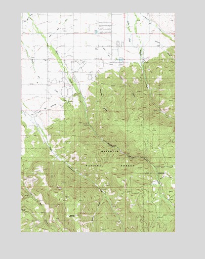
Wheeler Mountain, MT USGS Topographic Map
Click on map above to begin viewing in our Map Viewer.

This topographic map contains these locations and features:
Feature Name Type Latitude Longitude GNIS ID View Map
02S05E33CB__01 WellWellN45.6185°W111.1213°810590View Map
02S05E33DB__01 WellWellN45.6185°W111.1111°810588View Map
02S05E33DB__02 WellWellN45.6185°W111.1111°810589View Map
02S05E34CD__01 WellWellN45.6149°W111.0955°810558View Map
02S05E35CB__01 WellWellN45.6185°W111.0802°810587View Map
02S05E35DCDC01 WellWellN45.6149°W111.0699°810557View Map
02S05E35DD__01 WellWellN45.6149°W111.0647°810555View Map
02S05E35DD__02 WellWellN45.6149°W111.0647°810556View Map
02S05E36BACD01 WellWellN45.6238°W111.0558°810623View Map
02S05E36BADD01 WellWellN45.6241°W111.0533°810626View Map
02S05E36DD__01 WellWellN45.6149°W111.0441°810554View Map
02S06E31AD__01 WellWellN45.6222°W111.0241°810615View Map
02S06E31DB__01 WellWellN45.6185°W111.0294°810586View Map
02S06E32CB__02 WellWellN45.6185°W111.0191°810585View Map
03S05E01AC__01 WellWellN45.6077°W111.0488°810476View Map
03S05E01BA__01 WellWellN45.6113°W111.0541°810524View Map
03S05E01DC__01 WellWellN45.6005°W111.0488°810416View Map
03S05E02AD__01 WellWellN45.6077°W111.0644°810477View Map
03S05E02CD__01 WellWellN45.6005°W111.0749°810417View Map
03S05E02DA__01 WellWellN45.6041°W111.0644°810450View Map
03S05E03AB__01 WellWellN45.6113°W111.0905°810525View Map
03S05E03BB__01 WellWellN45.6113°W111.1011°810526View Map
03S05E03DA__01 WellWellN45.6041°W111.0852°810451View Map
03S05E04AAAD01 WellWellN45.6113°W111.1049°810527View Map
03S05E04AB__01 WellWellN45.6113°W111.1113°810528View Map
03S05E04BA__01 WellWellN45.6113°W111.1166°810529View Map
03S05E04CD__01 SpringSpringN45.6005°W111.1166°810418View Map
03S05E09AA__01 WellWellN45.5966°W111.1061°810383View Map
03S05E09DA__01 WellWellN45.5894°W111.1061°810308View Map
03S05E10BA__01 WellWellN45.5966°W111.0958°810381View Map
03S05E10BB__01 WellWellN45.5966°W111.1011°810382View Map
03S05E10CCCB01 WellWellN45.5852°W111.1036°810272View Map
03S05E10DB__01 WellWellN45.5894°W111.0905°810307View Map
03S05E11BC__01 WellWellN45.5930°W111.0802°810345View Map
03S05E11DA__01 SpringSpringN45.5894°W111.0644°810306View Map
03S05E11DAAC01 WellWellN45.5899°W111.0622°810316View Map
03S05E11DABD01 WellWellN45.5899°W111.0641°810317View Map
03S05E11DDB_01 SpringSpringN45.5866°W111.0658°810280View Map
03S05E11DDC_01 SpringSpringN45.5849°W111.0658°810270View Map
03S05E12CB__01 SpringSpringN45.5894°W111.0594°810305View Map
03S05E15CA__01 SpringSpringN45.5749°W111.0958°810224View Map
03S05E15DCCA01 WellWellN45.5705°W111.0922°810200View Map
03S05E16AA__01 WellWellN45.5822°W111.1061°810251View Map
03S05E21AB__01 WellWellN45.5674°W111.1113°810165View Map
03S05E21BBA_01 WellWellN45.5685°W111.1205°810181View Map
03S05E21BBBA01 WellWellN45.5691°W111.1241°810190View Map
03S05E21BBD_01 WellWellN45.5666°W111.1205°810158View Map
03S05E21BD__01 WellWellN45.5638°W111.1166°810142View Map
03S05E21BD__02 SpringSpringN45.5638°W111.1166°810143View Map
03S06E05BB__01 WellWellN45.6110°W111.0188°810505View Map
03S06E05CBAA01 WellWellN45.6052°W111.0177°810459View Map
03S06E06AC__01 WellWellN45.6074°W111.0291°810470View Map
03S06E06BA__01 SpringSpringN45.6110°W111.0341°810506View Map
03S06E06DA__01 WellWellN45.6038°W111.0238°810445View Map
03S06E06DD__01 WellWellN45.6002°W111.0238°810409View Map
03S06E06DD__02 WellWellN45.6002°W111.0238°810410View Map
Abbot Recreation SiteLocaleN45.5324°W111.0158°794925View Map
Anderson SchoolSchoolN45.5980°W111.1049°768253View Map
Buckskin CreekStreamN45.5302°W111.0152°780530View Map
Dry GulchValleyN45.5413°W111.0980°782612View Map
Haggerty AirportAirportN45.6213°W111.0924°2650674View Map
Hodgman CanyonValleyN45.5866°W111.0677°784912View Map
Hyalite CanyonValleyN45.5797°W111.0791°785186View Map
Hyalite StationLocaleN45.5713°W111.0727°785191View Map
KBOZ-AM (Bozeman)TowerN45.6160°W111.0886°806600View Map
Langohr SpringsSpringN45.5274°W111.0187°1743650View Map
Langohr Springs CampgroundLocaleN45.5277°W111.0166°785952View Map
Leverich CreekStreamN45.5980°W111.0477°786064View Map
Leverich School (historical)SchoolN45.6058°W111.0527°786065View Map
Middle Creek Association DitchCanalN45.5663°W111.1122°787230View Map
Middle Creek DitchCanalN45.6183°W111.0922°787233View Map
Moser CreekStreamN45.5366°W111.0169°787721View Map
Mystic Lake DitchCanalN45.5985°W111.0480°787899View Map
Nichols CreekStreamN45.6097°W111.0233°787988View Map
Sourdough Creek Fishing Access SiteLocaleN45.5866°W111.0230°1744506View Map
Sourdough Rural Fire District Station 2BuildingN45.5957°W111.1038°2546514View Map
Sunshine MineMineN45.5322°W111.0313°802994View Map
West Gallatin CanalCanalN45.6238°W111.1166°793104View Map
Wheeler GulchValleyN45.5194°W111.0586°793159View Map
Wheeler MountainSummitN45.5097°W111.0822°793160View Map

Note: Coordinates in the location and feature list above are referenced to NAD83 datum.


Copyright (C) 2008-2024 Ryan Niemi / Sunset Dynamics ... All Rights Reserved