TopoQuest Logo
Do you find TopoQuest useful?
Help keep TopoQuest running and adding new maps/features by donating!
Bitcoin:  19c7KJd3qBynnjoSw5npx9KScwjBe4ifkT
Litecoin:  LXs6TkuXGGXo1vDsWCkWVdjQX94eUKd6ui
Home View Maps Find Maps Find Places Resources & Links


Bozeman Hot Springs, Montana Topographic Map

USGS Map Title: Bozeman Hot Springs, MT
USGS Map MRC: 45111F2
DRG (GeoTIFF) Download: o45111f2.tif


Neighboring USGS Topographic Map Quads:


  Manhattan, MT  
45111G3
 

  Belgrade, MT  
45111G2
 

  Miser Creek, MT  
45111G1
 

  Anceney, MT  
45111F3
 

  Bozeman Hot Springs, MT  
45111F2
 

  Bozeman, MT  
45111F1
 

  Ruby Mountain, MT  
45111E3
 

  Gallatin Gateway, MT  
45111E2
 

  Wheeler Mountain, MT  
45111E1


Map MRC Location:

N46°
W112°
N46°
W111°
H8 H7 H6 H5 H4 H3 H2 H1
G8 G7 G6 G5 G4 G3 G2 G1
F8 F7 F6 F5 F4 F3 F2 F1
E8 E7 E6 E5 E4 E3 E2 E1
D8 D7 D6 D5 D4 D3 D2 D1
C8 C7 C6 C5 C4 C3 C2 C1
B8 B7 B6 B5 B4 B3 B2 B1
A8 A7 A6 A5 A4 A3 A2 A1
N45°
W112°
N45°
W111°

Bozeman Hot Springs, MT USGS 1:24K Topographic Map Preview:
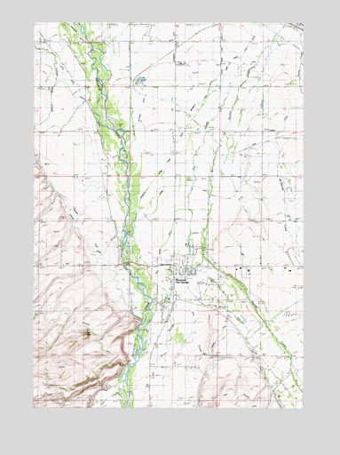
Bozeman Hot Springs, MT USGS Topographic Map
Click on map above to begin viewing in our Map Viewer.

This topographic map contains these locations and features:
Feature Name Type Latitude Longitude GNIS ID View Map
01S04328BB__01 WellWellN45.7269°W111.2455°811464View Map
01S04E13CC__01 WellWellN45.7449°W111.1836°811614View Map
01S04E13DD__01 WellWellN45.7449°W111.1683°811613View Map
01S04E14CA__01 WellWellN45.7494°W111.1983°811641View Map
01S04E14CC__01 WellWellN45.7449°W111.2041°811615View Map
01S04E15CD__01 WellWellN45.7449°W111.2197°811616View Map
01S04E16DC__01 WellWellN45.7449°W111.2350°811618View Map
01S04E16DC__02 WellWellN45.7449°W111.2350°811619View Map
01S04E16DD__01 WellWellN45.7449°W111.2300°811617View Map
01S04E21AD__01 WellWellN45.7377°W111.2300°811554View Map
01S04E22CD__01 WellWellN45.7305°W111.2197°811493View Map
01S04E22DA__01 WellWellN45.7341°W111.2094°811524View Map
01S04E22DA__02 WellWellN45.7341°W111.2094°811525View Map
01S04E23AA__01 WellWellN45.7413°W111.1888°811579View Map
01S04E23DD__01 WellWellN45.7302°W111.1888°811488View Map
01S04E24BB__01 WellWellN45.7413°W111.1838°811578View Map
01S04E24BC__01 WellWellN45.7374°W111.1838°811552View Map
01S04E24CD__01 WellWellN45.7302°W111.1788°811487View Map
01S04E24DA__01 WellWellN45.7338°W111.1683°811521View Map
01S04E25AA__01 WellWellN45.7266°W111.1686°811454View Map
01S04E25AA__02 WellWellN45.7266°W111.1686°811455View Map
01S04E25AAA_03 WellWellN45.7197°W111.1650°811394View Map
01S04E25ADDD01 WellWellN45.7227°W111.1652°811423View Map
01S04E25BA__01 WellWellN45.7266°W111.1788°811456View Map
01S04E25BA__02 WellWellN45.7266°W111.1788°811457View Map
01S04E25BA__03 WellWellN45.7266°W111.1788°811458View Map
01S04E25CC__01 WellWellN45.7163°W111.1827°811363View Map
01S04E25CC__02 WellWellN45.7163°W111.1827°811364View Map
01S04E25DA__02 WellWellN45.7338°W111.1683°811522View Map
01S04E26BBA_01 WellWellN45.7277°W111.2030°811471View Map
01S04E26BBB_01 WellWellN45.7277°W111.2058°811472View Map
01S04E26CD__01 WellWellN45.7163°W111.1983°811366View Map
01S04E26DA__01 WellWellN45.7199°W111.1880°811396View Map
01S04E26DD__02 WellWellN45.7163°W111.1880°811365View Map
01S04E27BB__01 WellWellN45.7269°W111.2250°811463View Map
01S04E33AA__01 WellWellN45.7127°W111.2294°811347View Map
01S04E34BD__01 WellWellN45.7091°W111.2191°811323View Map
01S04E34DB__01 WellWellN45.7055°W111.2138°811285View Map
01S04E35AD__01 WellWellN45.7091°W111.1880°811319View Map
01S04E35AD__02 WellWellN45.7091°W111.1880°811320View Map
01S04E35BD__01 WellWellN45.7091°W111.1983°811321View Map
01S04E35BD__02 WellWellN45.7091°W111.1983°811322View Map
01S04E36DD__01 WellWellN45.7019°W111.1672°811258View Map
01S04E36DD__03 WellWellN45.7019°W111.1672°811259View Map
01S05E17CC__01 WellWellN45.7449°W111.1422°811611View Map
01S05E17CCDC01 WellWellN45.7441°W111.1416°811597View Map
01S05E17DB__01 WellWellN45.7494°W111.1313°811640View Map
01S05E18CC__01 WellWellN45.7449°W111.1630°811612View Map
01S05E19CB__01 WellWellN45.7338°W111.1633°811520View Map
01S05E19CD__01 WellWellN45.7302°W111.1580°811486View Map
01S05E20BA__01 WellWellN45.7410°W111.1369°811577View Map
01S05E30AA__01 WellWellN45.7266°W111.1477°811453View Map
01S05E30CB__01 WellWellN45.7191°W111.1633°811390View Map
01S05E30CD__01 WellWellN45.7166°W111.1572°811372View Map
01S05E30DC__01 WellWellN45.7166°W111.1519°811371View Map
01S05E31CC__01 WellWellN45.7022°W111.1622°811272View Map
01S05E32CA__01 WellWellN45.7058°W111.1366°811297View Map
01S05E32DC__01 WellWellN45.7022°W111.1313°811271View Map
02S04E01AA__01 WellWellN45.6983°W111.1675°811222View Map
02S04E01AA__02 WellWellN45.6983°W111.1675°811223View Map
02S04E01BA__01 WellWellN45.6983°W111.1777°811224View Map
02S04E01BA__02 WellWellN45.6983°W111.1777°811225View Map
02S04E01DDB_01 WellWellN45.6883°W111.1686°811151View Map
02S04E04AA__01 WellWellN45.6983°W111.2294°811226View Map
02S04E04BD__01 WellWellN45.6947°W111.2400°811198View Map
02S04E09BCCC01 WellWellN45.6802°W111.2450°811080View Map
02S04E09CD__01 WellWellN45.6730°W111.2400°811022View Map
02S04E10DD__01 WellWellN45.6730°W111.2088°811021View Map
02S04E11ADDD01 WellWellN45.6785°W111.1866°811059View Map
02S04E11CD__01 WellWellN45.6730°W111.1986°811019View Map
02S04E11CD__02 WellWellN45.6730°W111.1986°811020View Map
02S04E11DC__01 WellWellN45.6719°W111.1947°811006View Map
02S04E13AA__01 WellWellN45.6694°W111.1675°810982View Map
02S04E13AB__01 WellWellN45.6694°W111.1725°810983View Map
02S04E13BC__01 WellWellN45.6658°W111.1830°810951View Map
02S04E13CBC_01 WellWellN45.6610°W111.1841°810905View Map
02S04E13CBD_01 WellWellN45.6610°W111.1816°810904View Map
02S04E13CC__01 WellWellN45.6585°W111.1830°810879View Map
02S04E13CCBC01 WellWellN45.6602°W111.1850°810901View Map
02S04E13CD__01 WellWellN45.6585°W111.1777°810878View Map
02S04E13DA__01 WellWellN45.6622°W111.1675°810923View Map
02S04E13DD__01 WellWellN45.6585°W111.1675°810877View Map
02S04E14AA__01 WellWellN45.6694°W111.1880°810984View Map
02S04E14AC__01 WellWellN45.6658°W111.1933°810952View Map
02S04E14ADA_01 WellWellN45.6666°W111.1869°810960View Map
02S04E14ADA_02 WellWellN45.6666°W111.1869°810961View Map
02S04E14ADD_01 WellWellN45.6647°W111.1869°810944View Map
02S04E14BB__01 WellWellN45.6694°W111.2036°810985View Map
02S04E14DAA_01 WellWellN45.6630°W111.1869°810932View Map
02S04E14DAC_01 WellWellN45.6610°W111.1894°810909View Map
02S04E14DAC_02 SpringSpringN45.6610°W111.1894°810910View Map
02S04E14DAD_01 SpringSpringN45.6610°W111.1877°810903View Map
02S04E14DADC01 SpringSpringN45.6610°W111.1877°810906View Map
02S04E14DADC02 SpringSpringN45.6610°W111.1877°810907View Map
02S04E14DADC03 WellWellN45.6610°W111.1877°810908View Map
02S04E14DC__01 WellWellN45.6585°W111.1933°810881View Map
02S04E14DD__01 WellWellN45.6585°W111.1880°810880View Map
02S04E14DDB_01 WellWellN45.6597°W111.1900°810896View Map
02S04E15DA__01 WellWellN45.6622°W111.2088°810924View Map
02S04E16BCCA01 WellWellN45.6647°W111.2461°810945View Map
02S04E22DA__01 SpringSpringN45.6474°W111.2088°810791View Map
02S04E23AA__01 WellWellN45.6547°W111.1880°810841View Map
02S04E23AB__01 WellWellN45.6547°W111.1933°810842View Map
02S04E24DC__01 WellWellN45.6438°W111.1725°810766View Map
02S04E24DC__02 WellWellN45.6438°W111.1725°810767View Map
02S04E25BD__01 WellWellN45.6366°W111.1777°810721View Map
02S04E26AA__01 WellWellN45.6402°W111.1880°810741View Map
02S04E26AC__01 WellWellN45.6366°W111.1933°810722View Map
02S04E26DC__01 WellWellN45.6294°W111.1933°810678View Map
02S04E33AB__01 SpringSpringN45.6258°W111.2347°810652View Map
02S04E35ABBB01 WellWellN45.6269°W111.1966°810659View Map
02S05E05ABBB01 WellWellN45.6994°W111.1344°811241View Map
02S05E05ABBD01 WellWellN45.6991°W111.1327°811238View Map
02S05E05BA__01 WellWellN45.6988°W111.1366°811235View Map
02S05E05DC__01 WellWellN45.6880°W111.1316°811147View Map
02S05E06BA__01 WellWellN45.6988°W111.1572°811236View Map
02S05E06DC__01 WellWellN45.6880°W111.1522°811148View Map
02S05E07AA__01 WellWellN45.6844°W111.1469°811112View Map
02S05E08BC__01 WellWellN45.6808°W111.1419°811086View Map
02S05E08DB__01 WellWellN45.6769°W111.1316°811050View Map
02S05E17BA__01 WellWellN45.6697°W111.1366°810997View Map
02S05E17BBAA01 WellWellN45.6705°W111.1411°811001View Map
02S05E17DA__01 WellWellN45.6624°W111.1263°810929View Map
02S05E17DDC_02 WellWellN45.6577°W111.1277°810871View Map
02S05E18CD__01 WellWellN45.6588°W111.1572°810891View Map
02S05E19BC__01 WellWellN45.6513°W111.1625°810822View Map
02S05E20AA__01 WellWellN45.6549°W111.1263°810857View Map
02S05E20AD__01 WellWellN45.6513°W111.1263°810820View Map
02S05E20AD__02 WellWellN45.6513°W111.1263°810821View Map
02S05E20CC__01 WellWellN45.6441°W111.1419°810771View Map
02S05E20DA__01 WellWellN45.6477°W111.1263°810796View Map
02S05E20DDCC01 WellWellN45.6422°W111.1294°810758View Map
02S05E29AC__01 WellWellN45.6369°W111.1316°810724View Map
02S05E29CB__01 WellWellN45.6330°W111.1419°810705View Map
02S05E29CD__01 WellWellN45.6294°W111.1366°810677View Map
02S05E29DA__01 WellWellN45.6330°W111.1263°810704View Map
02S05E30AA__01 WellWellN45.6405°W111.1469°810745View Map
02S05E32AA__01 WellWellN45.6258°W111.1263°810651View Map
Abundant Life Fellowship ChurchChurchN45.6708°W111.1522°1743781View Map
Beck Border DitchCanalN45.6972°W111.1558°768655View Map
BlackwoodPopulated PlaceN45.6419°W111.1455°769013View Map
Blackwood (historical)LocaleN45.6419°W111.1455°1743898View Map
Bopp DitchCanalN45.7144°W111.2061°769111View Map
Bozeman Hot SpringsSpringN45.6599°W111.1852°769174View Map
Bozeman Hot SpringsLocaleN45.6666°W111.1841°1743894View Map
Bozeman KOA KampgroundLocaleN45.6583°W111.1897°1737961View Map
Cameron BridgeBridgeN45.7435°W111.2252°769522View Map
Cameron Bridge Fishing Access SiteLocaleN45.7377°W111.2200°1744483View Map
Cameron School (historical)SchoolN45.7291°W111.2261°769528View Map
Central Valley Fire District Station 3BuildingN45.6756°W111.1911°2546488View Map
Chapman (historical)LocaleN45.6277°W111.1286°1743880View Map
Clark DitchCanalN45.6910°W111.2161°769896View Map
CowanPopulated PlaceN45.7235°W111.1852°802080View Map
Dogtown (historical)Populated PlaceN45.7083°W111.1730°1743890View Map
Dry CreekStreamN45.7291°W111.1555°770769View Map
Elk Grove School (historical)SchoolN45.6385°W111.1913°771189View Map
Elk Grove SloughGutN45.6463°W111.1886°771190View Map
Erskine Bridge (historical)BridgeN45.6638°W111.1536°1737918View Map
Farmers CanalCanalN45.6341°W111.1716°783308View Map
Fish CreekStreamN45.6316°W111.2113°783429View Map
Forest Park Mobile Home and RV ParkPopulated PlaceN45.6749°W111.2077°1738026View Map
Four CornersPopulated PlaceN45.6297°W111.1861°806243View Map
Four Corners Baptist ChurchChurchN45.6705°W111.1825°1743766View Map
Four Corners Census Designated PlaceCensusN45.6704°W111.1780°2408250View Map
GilroyPopulated PlaceN45.6599°W111.1650°771779View Map
Gilroy (historical)LocaleN45.6599°W111.1650°1743877View Map
GreenwoodPopulated PlaceN45.6772°W111.2122°802115View Map
Greenwood (historical)LocaleN45.6772°W111.2122°1743871View Map
Greenwood Post Office (historical)Post OfficeN45.6772°W111.2122°1743795View Map
HollandPopulated PlaceN45.7441°W111.2452°772473View Map
Hot Springs (historical)LocaleN45.6666°W111.1841°1743895View Map
Hulbert DitchCanalN45.6847°W111.1580°772607View Map
KernsPopulated PlaceN45.7116°W111.1447°802128View Map
Ketterer DitchCanalN45.7180°W111.2019°773010View Map
Keughen DitchCanalN45.7016°W111.2461°773011View Map
King Arthur Park Census Designated PlaceCensusN45.6664°W111.1269°2583820View Map
Knadler DitchCanalN45.7330°W111.2061°773101View Map
Korner KourtPopulated PlaceN45.6727°W111.1863°1738016View Map
Mammoth DitchCanalN45.7327°W111.1852°773852View Map
Mammoth Fork DitchCanalN45.7272°W111.1697°773853View Map
McCullough DitchCanalN45.7302°W111.2047°773985View Map
McDonald CreekStreamN45.7116°W111.1441°773998View Map
Middle Creek (historical)Populated PlaceN45.6999°W111.1697°1743854View Map
Middle Creek Post Office (historical)Post OfficeN45.6999°W111.1697°1743805View Map
Middle Creek School (historical)SchoolN45.6327°W111.1366°774148View Map
Middle Supply DitchCanalN45.6660°W111.1850°774191View Map
Monforton (historical)Populated PlaceN45.6752°W111.1708°1743852View Map
Monforton SchoolSchoolN45.6756°W111.1705°774335View Map
New Life United Methodist ChurchChurchN45.7444°W111.1863°1743776View Map
Pine ButteSummitN45.6488°W111.2269°802163View Map
Pine Butte SchoolSchoolN45.6705°W111.2494°775230View Map
Potter (historical)LocaleN45.6333°W111.1361°1743845View Map
Riverside Trailer CourtPopulated PlaceN45.6749°W111.2077°1738027View Map
Robinson DitchCanalN45.6758°W111.1522°775832View Map
Sheds (historical)Populated PlaceN45.6722°W111.2041°1743837View Map
Sheds BridgeBridgeN45.6722°W111.2088°776423View Map
Sheds Bridge Fishing Access SiteLocaleN45.6738°W111.2083°1744495View Map
Sheds Post Office (historical)Post OfficeN45.6722°W111.2041°1743811View Map
South Dry CreekStreamN45.6899°W111.1786°790895View Map
Spain Ferris DitchCanalN45.7177°W111.1783°776922View Map
StoneCanalN45.7447°W111.2197°777232View Map
Waterman School (historical)SchoolN45.7288°W111.1644°778139View Map
West GallatinPopulated PlaceN45.7027°W111.2188°802236View Map

Note: Coordinates in the location and feature list above are referenced to NAD83 datum.


Copyright (C) 2008-2024 Ryan Niemi / Sunset Dynamics ... All Rights Reserved