TopoQuest Logo
Do you find TopoQuest useful?
Help keep TopoQuest running and adding new maps/features by donating!
Bitcoin:  19c7KJd3qBynnjoSw5npx9KScwjBe4ifkT
Litecoin:  LXs6TkuXGGXo1vDsWCkWVdjQX94eUKd6ui
Home View Maps Find Maps Find Places Resources & Links


Booneville, Kentucky Topographic Map

USGS Map Title: Booneville, KY
USGS Map MRC: 37083D6
DRG (GeoTIFF) Download: o37083d6.tif


Neighboring USGS Topographic Map Quads:


  Heidelberg, KY  
37083E7
 

  Beattyville, KY  
37083E6
 

  Tallega, KY  
37083E5
 

  Sturgeon, KY  
37083D7
 

  Booneville, KY  
37083D6
 

  Cowcreek, KY  
37083D5
 

  Maulden, KY  
37083C7
 

  Oneida, KY  
37083C6
 

  Mistletoe, KY  
37083C5


Map MRC Location:

N38°
W84°
N38°
W83°
H8 H7 H6 H5 H4 H3 H2 H1
G8 G7 G6 G5 G4 G3 G2 G1
F8 F7 F6 F5 F4 F3 F2 F1
E8 E7 E6 E5 E4 E3 E2 E1
D8 D7 D6 D5 D4 D3 D2 D1
C8 C7 C6 C5 C4 C3 C2 C1
B8 B7 B6 B5 B4 B3 B2 B1
A8 A7 A6 A5 A4 A3 A2 A1
N37°
W84°
N37°
W83°

Booneville, KY USGS 1:24K Topographic Map Preview:
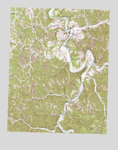
Booneville, KY USGS Topographic Map
Click on map above to begin viewing in our Map Viewer.

This topographic map contains these locations and features:
Feature Name Type Latitude Longitude GNIS ID View Map
Bear RunStreamN37.4465°W83.6424°510471View Map
Betty Bowman CreekStreamN37.4456°W83.6738°510581View Map
Betty Thomas BranchStreamN37.4137°W83.6774°510585View Map
BlakePopulated PlaceN37.3870°W83.7391°510775View Map
Blake Post Office (historical)Post OfficeN37.3872°W83.7388°2416350View Map
Boone SpringSpringN37.4771°W83.6781°2416551View Map
Boones RockPillarN37.4592°W83.7300°2416552View Map
BoonevillePopulated PlaceN37.4762°W83.6749°510852View Map
Booneville DivisionCivilN37.4853°W83.6608°1936882View Map
Booneville Owsley Fire DepartmentBuildingN37.4764°W83.6750°2636701View Map
Booneville Post OfficePost OfficeN37.4793°W83.6738°2416351View Map
Brookside SchoolSchoolN37.3770°W83.6963°2416555View Map
Buck CreekStreamN37.4795°W83.6746°511003View Map
Buck Creek Post Office (historical)Post OfficeN37.4631°W83.7402°2416354View Map
Cawood BendBendN37.4586°W83.6507°2416557View Map
Chestnut GapPopulated PlaceN37.4587°W83.6588°511333View Map
Chestnut Gap SchoolSchoolN37.4507°W83.6607°2416559View Map
Chestnut Neighborhood (historical)Populated PlaceN37.4583°W83.6589°2416560View Map
City of BoonevilleCivilN37.4743°W83.6801°2403897View Map
Clifty ChurchChurchN37.4606°W83.7207°511407View Map
ConklingPopulated PlaceN37.3815°W83.6899°511500View Map
Conkling Post OfficePost OfficeN37.3916°W83.6844°2416561View Map
Cow CreekStreamN37.4465°W83.6438°511592View Map
Do Creek SchoolSchoolN37.3931°W83.6966°2416568View Map
Doe CreekStreamN37.3918°W83.6841°516629View Map
Elk Lick ChurchChurchN37.4634°W83.7399°512042View Map
Elk Lick Neighborhood (historical)Populated PlaceN37.4632°W83.7396°2416569View Map
Essau ChurchChurchN37.4126°W83.6332°512085View Map
Essau SchoolSchoolN37.4121°W83.6333°2416570View Map
EversolePopulated PlaceN37.4476°W83.6427°512101View Map
Eversole Post OfficePost OfficeN37.4343°W83.6523°2416572View Map
Fish CreekStreamN37.4904°W83.6905°512162View Map
Fish Creek SchoolSchoolN37.4998°W83.6727°517521View Map
Gabbard BranchStreamN37.4109°W83.6344°512269View Map
Gilbert BranchStreamN37.4192°W83.6566°2416576View Map
Greenville HollowValleyN37.4887°W83.6357°512449View Map
Griffith CemeteryCemeteryN37.4137°W83.6649°512465View Map
High Rock MountainSummitN37.4150°W83.6406°2416583View Map
Hogg Neighborhood (historical)Populated PlaceN37.4108°W83.6325°2416584View Map
Horse BranchStreamN37.4846°W83.6884°2416585View Map
Howard CemeteryCemeteryN37.4812°W83.6757°2120781View Map
Howland ChapelChurchN37.4426°W83.7266°2416586View Map
Indian CreekStreamN37.4287°W83.6580°512904View Map
Left Fork Island CreekStreamN37.3776°W83.6919°513314View Map
LeviPopulated PlaceN37.4804°W83.7207°513349View Map
Levi Post Office (historical)Post OfficeN37.4803°W83.7178°2416361View Map
Lower Island CreekStreamN37.3843°W83.6855°513697View Map
Lower Wolf CreekStreamN37.4095°W83.6641°516628View Map
MajorPopulated PlaceN37.4140°W83.6985°513764View Map
Major Post OfficePost OfficeN37.4093°W83.7166°2416588View Map
McGuire ForkStreamN37.3865°W83.7299°513864View Map
McIntosh CemeteryCemeteryN37.4687°W83.7091°513868View Map
Meadow CreekStreamN37.4784°W83.6694°513890View Map
Mill Town BranchStreamN37.4599°W83.6781°2416589View Map
Mine KnobSummitN37.4726°W83.6956°2416590View Map
Mud LickStreamN37.4131°W83.7238°2416593View Map
Owsely County High SchoolSchoolN37.4747°W83.6695°2416600View Map
Owsley CountyCivilN37.4192°W83.6831°516941View Map
Owsley County Sheriff's OfficeBuildingN37.4760°W83.6751°2767667View Map
Peachtree BranchStreamN37.4130°W83.7236°2416596View Map
Pendergrass CemeteryCemeteryN37.4926°W83.7213°514480View Map
Pleasant Grove SchoolSchoolN37.4925°W83.7236°2416598View Map
Pleasant Neighborhood (historical)Populated PlaceN37.4931°W83.7236°2416599View Map
Posey Post Office (historical)Post OfficeN37.4536°W83.7197°2416363View Map
Rowland BranchStreamN37.4129°W83.6979°2416332View Map
ScovillePopulated PlaceN37.4540°W83.7199°515302View Map
Scoville High School (historical)SchoolN37.4536°W83.7193°2416366View Map
Scoville Post Office (historical)Post OfficeN37.4535°W83.7196°2416367View Map
Shepherd CemeteryCemeteryN37.4745°W83.6644°515349View Map
SouthforkPopulated PlaceN37.4143°W83.6619°515561View Map
Southfork Post OfficePost OfficeN37.4142°W83.6617°2416336View Map
Spencer ChurchChurchN37.4879°W83.6263°515579View Map
Sugar Camp CreekStreamN37.4820°W83.6552°515786View Map
Sugar Camp Neighborhood (historical)Populated PlaceN37.4701°W83.6394°2416339View Map
Sugar Camp SchoolSchoolN37.4702°W83.6389°2416340View Map
The SagBasinN37.4756°W83.6899°515919View Map
Turin Post OfficePost OfficeN37.4658°W83.6833°2416341View Map
Turkey KnobSummitN37.4578°W83.7300°2416342View Map
Upper Wolf CreekStreamN37.3965°W83.6763°516166View Map
Upper Wolf Creek SchoolSchoolN37.3937°W83.6725°2416343View Map
Walnut Grove ChurchChurchN37.3915°W83.7496°516216View Map
White Oak CreekStreamN37.4076°W83.6682°516317View Map
White Oak SchoolSchoolN37.4122°W83.6795°2416345View Map

Note: Coordinates in the location and feature list above are referenced to NAD83 datum.


Copyright (C) 2008-2025 Ryan Niemi / Sunset Dynamics ... All Rights Reserved