TopoQuest Logo
Do you find TopoQuest useful?
Help keep TopoQuest running and adding new maps/features by donating!
Bitcoin:  19c7KJd3qBynnjoSw5npx9KScwjBe4ifkT
Litecoin:  LXs6TkuXGGXo1vDsWCkWVdjQX94eUKd6ui
Home View Maps Find Maps Find Places Resources & Links


White Gate, Virginia Topographic Map

USGS Map Title: White Gate, VA
USGS Map MRC: 37080B7
DRG (GeoTIFF) Download: o37080b7.tif


Neighboring USGS Topographic Map Quads:


  Oakvale, WV  
37080C8
 

  Narrows, VA  
37080C7
 

  Pearisburg, VA  
37080C6
 

  Mechanicsburg, VA  
37080B8
 

  White Gate, VA  
37080B7
 

  Staffordsville, VA  
37080B6
 

  Long Spur, VA  
37080A8
 

  Pulaski, VA  
37080A7
 

  Dublin, VA  
37080A6


Map MRC Location:

N38°
W81°
N38°
W80°
H8 H7 H6 H5 H4 H3 H2 H1
G8 G7 G6 G5 G4 G3 G2 G1
F8 F7 F6 F5 F4 F3 F2 F1
E8 E7 E6 E5 E4 E3 E2 E1
D8 D7 D6 D5 D4 D3 D2 D1
C8 C7 C6 C5 C4 C3 C2 C1
B8 B7 B6 B5 B4 B3 B2 B1
A8 A7 A6 A5 A4 A3 A2 A1
N37°
W81°
N37°
W80°

White Gate, VA USGS 1:24K Topographic Map Preview:
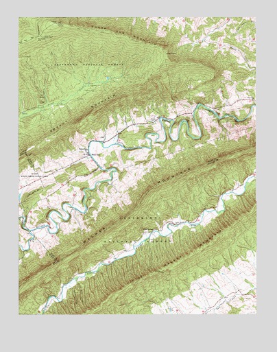
White Gate, VA USGS Topographic Map
Click on map above to begin viewing in our Map Viewer.

This topographic map contains these locations and features:
Feature Name Type Latitude Longitude GNIS ID View Map
Alum SpringsPopulated PlaceN37.1598°W80.8045°1499052View Map
Big Horse GapGapN37.2421°W80.8640°1481739View Map
Bland County Farm DamDamN37.1735°W80.8748°1489250View Map
Dismal Peak Fire TowerLocaleN37.2476°W80.8548°1494542View Map
Farmer Back Creek FarmLocaleN37.1372°W80.7606°2675998View Map
Flat HollowValleyN37.1871°W80.8324°1483440View Map
Flat Top MountainSummitN37.2410°W80.8692°1500065View Map
High PointCliffN37.2343°W80.7965°1484085View Map
Honey Spring Patrol CabinLocaleN37.2418°W80.8609°1484191View Map
Kimberling CreekStreamN37.1601°W80.8690°1484600View Map
Little CreekPopulated PlaceN37.1485°W80.8742°1494640View Map
Massie DistrictCivilN37.1289°W80.7655°1927392View Map
Mount Zion ChurchChurchN37.1562°W80.8670°1485661View Map
Pine Grove School (historical)SchoolN37.2079°W80.7917°1494568View Map
Poplar Hill Volunteer Fire DepartmentBuildingN37.2078°W80.7960°2086271View Map
Ripple TrailTrailN37.2293°W80.8579°1488681View Map
Sassin (historical)Populated PlaceN37.1585°W80.8012°1501479View Map
Sassin ChurchChurchN37.1637°W80.7923°1486948View Map
Shady Grove ChurchChurchN37.2157°W80.7509°1487018View Map
Silver Mine HollowValleyN37.1382°W80.8447°1487245View Map
Sugar Run MountainSummitN37.2476°W80.8540°1487699View Map
Sulphur HollowValleyN37.1365°W80.8467°1487712View Map
Walkers Creek Academy (historical)SchoolN37.1929°W80.8390°1674449View Map
Walkers Creek Baptist ChurchChurchN37.1890°W80.8337°1674450View Map
Walkers Creek CemeteryCemeteryN37.1937°W80.8395°1494576View Map
Walkers Creek ChurchChurchN37.1935°W80.8379°1488164View Map
Wapiti ShelterLocaleN37.2146°W80.8615°1488184View Map
Wapitu ShelterLocaleN37.2237°W80.8248°1488682View Map
White GateLocaleN37.1923°W80.8376°1488285View Map

Note: Coordinates in the location and feature list above are referenced to NAD83 datum.


Copyright (C) 2008-2025 Ryan Niemi / Sunset Dynamics ... All Rights Reserved