TopoQuest Logo
Do you find TopoQuest useful?
Help keep TopoQuest running and adding new maps/features by donating!
Bitcoin:  19c7KJd3qBynnjoSw5npx9KScwjBe4ifkT
Litecoin:  LXs6TkuXGGXo1vDsWCkWVdjQX94eUKd6ui
Home View Maps Find Maps Find Places Resources & Links


Staffordsville, Virginia Topographic Map

USGS Map Title: Staffordsville, VA
USGS Map MRC: 37080B6
DRG (GeoTIFF) Download: o37080b6.tif


Neighboring USGS Topographic Map Quads:


  Narrows, VA  
37080C7
 

  Pearisburg, VA  
37080C6
 

  Eggleston, VA  
37080C5
 

  White Gate, VA  
37080B7
 

  Staffordsville, VA  
37080B6
 

  Radford North, VA  
37080B5
 

  Pulaski, VA  
37080A7
 

  Dublin, VA  
37080A6
 

  Radford South, VA  
37080A5


Map MRC Location:

N38°
W81°
N38°
W80°
H8 H7 H6 H5 H4 H3 H2 H1
G8 G7 G6 G5 G4 G3 G2 G1
F8 F7 F6 F5 F4 F3 F2 F1
E8 E7 E6 E5 E4 E3 E2 E1
D8 D7 D6 D5 D4 D3 D2 D1
C8 C7 C6 C5 C4 C3 C2 C1
B8 B7 B6 B5 B4 B3 B2 B1
A8 A7 A6 A5 A4 A3 A2 A1
N37°
W81°
N37°
W80°

Staffordsville, VA USGS 1:24K Topographic Map Preview:
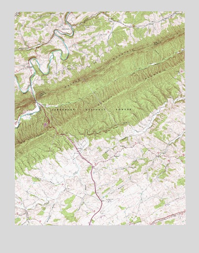
Staffordsville, VA USGS Topographic Map
Click on map above to begin viewing in our Map Viewer.

This topographic map contains these locations and features:
Feature Name Type Latitude Longitude GNIS ID View Map
Anderson-Vickers CemeteryCemeteryN37.1582°W80.6620°1481318View Map
Back Creek Chapel (historical)ChurchN37.1287°W80.7384°1501403View Map
Back HollowValleyN37.1258°W80.7295°1481381View Map
Bear SpringPopulated PlaceN37.2476°W80.6337°1499101View Map
Bear Spring ChurchChurchN37.2473°W80.6353°1501392View Map
Beaufort HollowValleyN37.1270°W80.7390°1481559View Map
Belle Hampton MineMineN37.1926°W80.6665°1501406View Map
Carper BranchStreamN37.1560°W80.7040°1482330View Map
Christiansburg Police DepartmentBuildingN37.2172°W80.6900°2086119View Map
Cloyd DistrictCivilN37.1748°W80.6334°1927154View Map
Cloyds MountainSummitN37.1935°W80.6903°1482599View Map
Fellowship ChurchChurchN37.1696°W80.7006°1483398View Map
French ChapelChurchN37.1957°W80.7312°1483539View Map
HighlandPopulated PlaceN37.1648°W80.6787°1499557View Map
Highland ChurchChurchN37.1707°W80.6692°1484096View Map
Highland Emmanuel CemeteryCemeteryN37.1704°W80.6701°1501436View Map
Little Walker CreekStreamN37.2071°W80.7376°1485000View Map
McGavock CreekStreamN37.1582°W80.6681°1485294View Map
Millerplace BranchStreamN37.1404°W80.7192°1485473View Map
New River Valley AirportAirportN37.1383°W80.6810°1498655View Map
Poplar HillPopulated PlaceN37.2176°W80.7390°1486350View Map
Racepath BranchStreamN37.1515°W80.7137°1486478View Map
Shannon-King CemeteryCemeteryN37.2182°W80.7415°1487029View Map
Shuffle BranchStreamN37.1804°W80.6615°1487228View Map
Shuffle RidgeRidgeN37.1812°W80.6787°1487229View Map
Slabtown BranchStreamN37.1340°W80.7417°1487294View Map
SpringdalePopulated PlaceN37.2162°W80.7115°1500143View Map
StaffordsvillePopulated PlaceN37.2415°W80.7167°1500147View Map
Staffordsville CemeteryCemeteryN37.2376°W80.7087°1494573View Map
Staffordsville Post OfficePost OfficeN37.2398°W80.7079°2766300View Map
TriggPopulated PlaceN37.2457°W80.6801°1500235View Map
Wabash (historical)Populated PlaceN37.2285°W80.7398°1501398View Map
Wabash CreekStreamN37.2368°W80.7195°1488141View Map
Wesley ChapelChurchN37.2446°W80.6803°1488234View Map
Wesley Chapel CemeteryCemeteryN37.2443°W80.6812°1494577View Map
Whitleys BranchStreamN37.2415°W80.7078°1488347View Map

Note: Coordinates in the location and feature list above are referenced to NAD83 datum.


Copyright (C) 2008-2025 Ryan Niemi / Sunset Dynamics ... All Rights Reserved