TopoQuest Logo
Do you find TopoQuest useful?
Help keep TopoQuest running and adding new maps/features by donating!
Bitcoin:  19c7KJd3qBynnjoSw5npx9KScwjBe4ifkT
Litecoin:  LXs6TkuXGGXo1vDsWCkWVdjQX94eUKd6ui
Home View Maps Find Maps Find Places Resources & Links


Narrows, Virginia Topographic Map

USGS Map Title: Narrows, VA
USGS Map MRC: 37080C7
DRG (GeoTIFF) Download: o37080c7.tif


Neighboring USGS Topographic Map Quads:


  Lerona, WV  
37080D8
 

  Peterstown, WV  
37080D7
 

  Lindside, WV  
37080D6
 

  Oakvale, WV  
37080C8
 

  Narrows, VA  
37080C7
 

  Pearisburg, VA  
37080C6
 

  Mechanicsburg, VA  
37080B8
 

  White Gate, VA  
37080B7
 

  Staffordsville, VA  
37080B6


Map MRC Location:

N38°
W81°
N38°
W80°
H8 H7 H6 H5 H4 H3 H2 H1
G8 G7 G6 G5 G4 G3 G2 G1
F8 F7 F6 F5 F4 F3 F2 F1
E8 E7 E6 E5 E4 E3 E2 E1
D8 D7 D6 D5 D4 D3 D2 D1
C8 C7 C6 C5 C4 C3 C2 C1
B8 B7 B6 B5 B4 B3 B2 B1
A8 A7 A6 A5 A4 A3 A2 A1
N37°
W81°
N37°
W80°

Narrows, VA USGS 1:24K Topographic Map Preview:
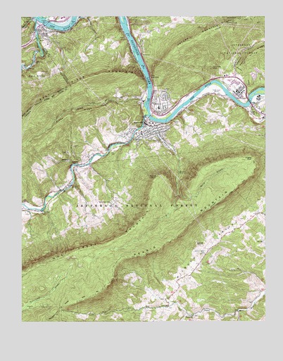
Narrows, VA USGS Topographic Map
Click on map above to begin viewing in our Map Viewer.

This topographic map contains these locations and features:
Feature Name Type Latitude Longitude GNIS ID View Map
Adair RunStreamN37.3748°W80.8679°1550075View Map
Adair RunStreamN37.3748°W80.8676°1481258View Map
Anderson E Shumate Memorial BridgeBridgeN37.3404°W80.7581°1494533View Map
Andrew S Rowan BridgeBridgeN37.3721°W80.8617°1494534View Map
Angels RestSummitN37.3162°W80.7617°1481324View Map
Blankenship CemeteryCemeteryN37.2996°W80.8292°1481842View Map
Blankenship School (historical)SchoolN37.2982°W80.8281°1494535View Map
Bluff CityPopulated PlaceN37.3382°W80.7562°1496808View Map
Bluff City United Methodist ChurchChurchN37.3373°W80.7534°1674422View Map
Bridge Number 2BridgeN37.3060°W80.8495°1494536View Map
Cedar Grove CemeteryCemeteryN37.2946°W80.8717°1494539View Map
Cedar Grove ChurchChurchN37.2951°W80.8709°1482403View Map
Central DistrictCivilN37.2564°W80.8010°1927140View Map
Day CemeteryCemeteryN37.3190°W80.8290°1482954View Map
East RiverStreamN37.3740°W80.8670°1483219View Map
Fairview CemeteryCemeteryN37.3384°W80.8073°1494545View Map
First Baptist ChurchChurchN37.3693°W80.8662°1494546View Map
First Christian ChurchChurchN37.3298°W80.8081°1674427View Map
First Presbyterian ChurchChurchN37.3285°W80.8112°1494548View Map
Fletcher School (historical)SchoolN37.3348°W80.7731°1494549View Map
FrenchPopulated PlaceN37.2960°W80.8706°1494550View Map
Glen LynPopulated PlaceN37.3682°W80.8642°1483667View Map
Glen Lyn Flyash DamDamN37.3701°W80.8665°1489855View Map
Glen Lyn Flyash PondReservoirN37.3701°W80.8665°1489856View Map
Glen Lyn Post OfficePost OfficeN37.3711°W80.8669°2766215View Map
Glen Lyn Volunteer Fire DepartmentBuildingN37.3695°W80.8643°2721030View Map
Hale CemeteryCemeteryN37.3259°W80.8204°1483889View Map
Hare CemeteryCemeteryN37.3396°W80.8137°1483938View Map
Hemlock RidgeRidgeN37.3610°W80.7548°1484027View Map
Mercy BranchStreamN37.3026°W80.7942°1485355View Map
Mill CreekStreamN37.3298°W80.8120°1485416View Map
NarrowsPopulated PlaceN37.3315°W80.8112°1497034View Map
Narrows Baptist ChurchChurchN37.3279°W80.8101°1674436View Map
Narrows Elementary - Middle SchoolSchoolN37.3268°W80.8131°1494560View Map
Narrows High SchoolSchoolN37.3377°W80.8044°1485795View Map
Narrows Police DepartmentBuildingN37.3310°W80.8110°2766939View Map
Narrows Post OfficePost OfficeN37.3310°W80.8102°2766256View Map
Narrows ReservoirReservoirN37.3114°W80.7942°1485796View Map
Narrows Volunteer Fire DepartmentBuildingN37.3300°W80.8107°2086275View Map
New Valley Fellowship ChurchChurchN37.3388°W80.8022°2563602View Map
North PearisburgPopulated PlaceN37.3418°W80.7706°1494561View Map
Pearis MountainSummitN37.3085°W80.7604°1486113View Map
Piney CreekStreamN37.3401°W80.8104°1486244View Map
Piney RidgeRidgeN37.3343°W80.8490°1486260View Map
Saunders Grove ChurchChurchN37.3548°W80.8742°1552807View Map
Sentinel PointSummitN37.3093°W80.8054°1486997View Map
ShumatePopulated PlaceN37.3148°W80.8481°1497151View Map
Stillhouse BranchStreamN37.3490°W80.7654°1487578View Map
The NarrowsGapN37.3504°W80.8087°1487836View Map
ThessaliaPopulated PlaceN37.2523°W80.7865°1497180View Map
Thessalia CemeteryCemeteryN37.2523°W80.7865°1494574View Map
Thessalia United Methodist ChurchChurchN37.2523°W80.7873°1494575View Map
Town of Glen LynCivilN37.3731°W80.8575°2390209View Map
Town of NarrowsCivilN37.3317°W80.8084°2391321View Map
Turnhole KnobSummitN37.3543°W80.7773°1497185View Map
Western DistrictCivilN37.3249°W80.8579°1927562View Map
Wilburn ValleyValleyN37.2598°W80.7997°1488364View Map
Wilburn Valley CemeteryCemeteryN37.2779°W80.7809°1488365View Map
Wilburn Valley School (historical)SchoolN37.2812°W80.7754°1494578View Map
Willowton School (historical)SchoolN37.3565°W80.8679°1553472View Map
WNRV Radio Tower (Tazewell)TowerN37.3446°W80.7767°1502821View Map
WNRV-AM (Narrows-Pearisburg)TowerN37.3443°W80.7765°1502514View Map
WNRV-FM (Narrows)TowerN37.3504°W80.7959°1502673View Map
Wolf CreekStreamN37.3346°W80.8098°1488442View Map
Woolwine CemeteryCemeteryN37.3304°W80.7951°1488486View Map

Note: Coordinates in the location and feature list above are referenced to NAD83 datum.


Copyright (C) 2008-2024 Ryan Niemi / Sunset Dynamics ... All Rights Reserved