TopoQuest Logo
Do you find TopoQuest useful?
Help keep TopoQuest running and adding new maps/features by donating!
Bitcoin:  19c7KJd3qBynnjoSw5npx9KScwjBe4ifkT
Litecoin:  LXs6TkuXGGXo1vDsWCkWVdjQX94eUKd6ui
Home View Maps Find Maps Find Places Resources & Links


White Lake, Wisconsin Topographic Map

USGS Map Title: White Lake, WI
USGS Map MRC: 45088B7
DRG (GeoTIFF) Download: o45088b7.tif


Neighboring USGS Topographic Map Quads:


  Pickerel, WI  
45088C8
 

  Lily, WI  
45088C7
 

  Reservoir Pond, WI  
45088C6
 

  Polar, WI  
45088B8
 

  White Lake, WI  
45088B7
 

  Langlade, WI  
45088B6
 

  Zoar, WI  
45088A8
 

  Perote Lake, WI  
45088A7
 

  Markton, WI  
45088A6


Map MRC Location:

N46°
W89°
N46°
W88°
H8 H7 H6 H5 H4 H3 H2 H1
G8 G7 G6 G5 G4 G3 G2 G1
F8 F7 F6 F5 F4 F3 F2 F1
E8 E7 E6 E5 E4 E3 E2 E1
D8 D7 D6 D5 D4 D3 D2 D1
C8 C7 C6 C5 C4 C3 C2 C1
B8 B7 B6 B5 B4 B3 B2 B1
A8 A7 A6 A5 A4 A3 A2 A1
N45°
W89°
N45°
W88°

White Lake, WI USGS 1:24K Topographic Map Preview:
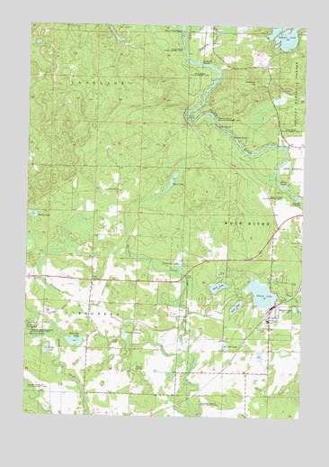
White Lake, WI USGS Topographic Map
Click on map above to begin viewing in our Map Viewer.

This topographic map contains these locations and features:
Feature Name Type Latitude Longitude GNIS ID View Map
Bear Caves State Natural AreaParkN45.2283°W88.7698°2057495View Map
Brown CemeteryCemeteryN45.1975°W88.8384°1578864View Map
Burnt Point RapidsRapidsN45.2483°W88.8051°1578897View Map
Cedar RapidsRapidsN45.2180°W88.7887°1578972View Map
Cozy Corner School (historical)SchoolN45.1322°W88.8276°1840753View Map
Dark LakeLakeN45.1665°W88.7881°1579082View Map
Evergreen Christian AcademySchoolN45.1679°W88.8733°2713315View Map
Evergreen CreekStreamN45.1414°W88.7990°1584501View Map
Evergreen River State Fishery AreaParkN45.1297°W88.7971°1579225View Map
Flora LakeLakeN45.1987°W88.8104°1579260View Map
Flora Spring Pond State Natural AreaParkN45.2005°W88.8101°2057497View Map
Four CornersPopulated PlaceN45.1683°W88.8448°1579281View Map
Galyan SpringsLakeN45.1404°W88.8249°1579308View Map
Hemlock RapidsRapidsN45.2144°W88.7821°1579432View Map
HollisterPopulated PlaceN45.2480°W88.7915°1579470View Map
Larzelere RapidsRapidsN45.1944°W88.7509°1579631View Map
Long LakeLakeN45.1493°W88.8354°1579735View Map
Mable LakeLakeN45.1461°W88.8654°1579795View Map
Ninemile CreekStreamN45.2389°W88.7984°1580009View Map
Ninemile HillSummitN45.2325°W88.7715°1580011View Map
Ninemile RapidsRapidsN45.2380°W88.7962°1580012View Map
Our LakeLakeN45.1475°W88.7845°1580074View Map
Oxbow RapidsRapidsN45.2205°W88.8021°1580080View Map
Oxbow Rapids Upper Wolf River State Natural AreaParkN45.2202°W88.8043°2057500View Map
Porkey LakeLakeN45.1890°W88.8724°1580199View Map
Saint James CemeteryCemeteryN45.1533°W88.7659°1580317View Map
Saint James CemeteryCemeteryN45.1686°W88.8720°1580318View Map
Sawyer LakeLakeN45.2475°W88.7591°1580350View Map
Sherry RapidsRapidsN45.2008°W88.7621°1580396View Map
Stillhouse SpringsLakeN45.1520°W88.8306°1580536View Map
Sunshine SpringsSpringN45.1511°W88.8732°1580559View Map
Town Line LakeLakeN45.1733°W88.8065°1580634View Map
Town of EvergreenCivilN45.1610°W88.8670°1583178View Map
Troutland Rescue SquadBuildingN45.1527°W88.7649°2698306View Map
Twin Hill LakeLakeN45.1486°W88.8526°1580671View Map
Village of White LakeCivilN45.1617°W88.7705°1584427View Map
West LakeLakeN45.1602°W88.7796°1580756View Map
White LakeLakeN45.1645°W88.7682°1580774View Map
White LakePopulated PlaceN45.1572°W88.7646°1580775View Map
White Lake Elementary SchoolSchoolN45.1559°W88.7650°2713366View Map
White Lake High SchoolSchoolN45.1559°W88.7650°2713333View Map
White Lake Volunteer Fire DepartmentBuildingN45.1528°W88.7649°2696823View Map
Wilson School (historical)SchoolN45.1614°W88.8340°1840824View Map

Note: Coordinates in the location and feature list above are referenced to NAD83 datum.


Copyright (C) 2008-2025 Ryan Niemi / Sunset Dynamics ... All Rights Reserved