TopoQuest Logo
Do you find TopoQuest useful?
Help keep TopoQuest running and adding new maps/features by donating!
Bitcoin:  19c7KJd3qBynnjoSw5npx9KScwjBe4ifkT
Litecoin:  LXs6TkuXGGXo1vDsWCkWVdjQX94eUKd6ui
Home View Maps Find Maps Find Places Resources & Links


Whitewater, Kansas Topographic Map

USGS Map Title: Whitewater, KS
USGS Map MRC: 37097H2
DRG (GeoTIFF) Download: o37097h2.tif


Neighboring USGS Topographic Map Quads:


  Newton, KS  
38097A3
 

  Elbing, KS  
38097A2
 

  Peabody SE, KS  
38097A1
 

  Sedgwick NE, KS  
37097H3
 

  Whitewater, KS  
37097H2
 

  Potwin, KS  
37097H1
 

  Valley Center, KS  
37097G3
 

  Greenwich, KS  
37097G2
 

  Benton, KS  
37097G1


Map MRC Location:

N38°
W98°
N38°
W97°
H8 H7 H6 H5 H4 H3 H2 H1
G8 G7 G6 G5 G4 G3 G2 G1
F8 F7 F6 F5 F4 F3 F2 F1
E8 E7 E6 E5 E4 E3 E2 E1
D8 D7 D6 D5 D4 D3 D2 D1
C8 C7 C6 C5 C4 C3 C2 C1
B8 B7 B6 B5 B4 B3 B2 B1
A8 A7 A6 A5 A4 A3 A2 A1
N37°
W98°
N37°
W97°

Whitewater, KS USGS 1:24K Topographic Map Preview:
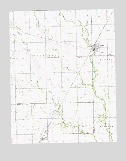
Whitewater, KS USGS Topographic Map
Click on map above to begin viewing in our Map Viewer.

This topographic map contains these locations and features:
Feature Name Type Latitude Longitude GNIS ID View Map
AnnellyPopulated PlaceN37.9722°W97.2011°484651View Map
City of WhitewaterCivilN37.9634°W97.1462°2397303View Map
Dubois Oil FieldOilfieldN37.9097°W97.1970°473706View Map
East Branch Whitewater CreekStreamN37.9681°W97.1575°473713View Map
Edgcomb (historical)LocaleN37.8978°W97.1517°482056View Map
Federated ChurchChurchN37.9636°W97.1477°2691035View Map
FurleyPopulated PlaceN37.8792°W97.2128°473703View Map
Furley Oil FieldOilfieldN37.8847°W97.2075°473704View Map
Grace Baptist ChurchChurchN37.9551°W97.1691°2691036View Map
Green Valley CemeteryCemeteryN37.8842°W97.1698°473705View Map
Gypsum CreekStreamN37.9286°W97.1525°473710View Map
Remington Middle SchoolSchoolN37.9631°W97.1459°2497555View Map
Sand CreekStreamN37.9020°W97.1917°473702View Map
Swiss CemeteryCemeteryN37.9798°W97.1349°473709View Map
Swiss ChurchChurchN37.9629°W97.1472°2691037View Map
Team Marketing Alliance Grain Elevator Number 37LocaleN37.9619°W97.1514°2695404View Map
Township of RichlandCivilN37.9562°W97.2080°473711View Map
West Branch Whitewater CreekStreamN37.9681°W97.1575°473712View Map
West Wildcat CreekStreamN37.9267°W97.2173°473701View Map
WhitewaterPopulated PlaceN37.9647°W97.1475°473708View Map
Whitewater CemeteryCemeteryN37.9550°W97.1703°473707View Map
Whitewater City HallBuildingN37.9624°W97.1484°2693231View Map
Whitewater Memorial LibraryBuildingN37.9628°W97.1484°2694890View Map
Whitewater Post OfficePost OfficeN37.9631°W97.1497°2694025View Map
Whitewater River Consolidated Fire District - Whitewater StationBuildingN37.9624°W97.1485°2111978View Map
Whitewater Wastewater PlantLocaleN37.9763°W97.1397°2691941View Map

Note: Coordinates in the location and feature list above are referenced to NAD83 datum.


Copyright (C) 2008-2025 Ryan Niemi / Sunset Dynamics ... All Rights Reserved