TopoQuest Logo
Do you find TopoQuest useful?
Help keep TopoQuest running and adding new maps/features by donating!
Bitcoin:  19c7KJd3qBynnjoSw5npx9KScwjBe4ifkT
Litecoin:  LXs6TkuXGGXo1vDsWCkWVdjQX94eUKd6ui
Home View Maps Find Maps Find Places Resources & Links


Potwin, Kansas Topographic Map

USGS Map Title: Potwin, KS
USGS Map MRC: 37097H1
DRG (GeoTIFF) Download: o37097h1.tif


Neighboring USGS Topographic Map Quads:


  Elbing, KS  
38097A2
 

  Peabody SE, KS  
38097A1
 

  Burns, KS  
38096A8
 

  Whitewater, KS  
37097H2
 

  Potwin, KS  
37097H1
 

  El Dorado NW, KS  
37096H8
 

  Greenwich, KS  
37097G2
 

  Benton, KS  
37097G1
 

  El Dorado SW, KS  
37096G8


Map MRC Location:

N38°
W98°
N38°
W97°
H8 H7 H6 H5 H4 H3 H2 H1
G8 G7 G6 G5 G4 G3 G2 G1
F8 F7 F6 F5 F4 F3 F2 F1
E8 E7 E6 E5 E4 E3 E2 E1
D8 D7 D6 D5 D4 D3 D2 D1
C8 C7 C6 C5 C4 C3 C2 C1
B8 B7 B6 B5 B4 B3 B2 B1
A8 A7 A6 A5 A4 A3 A2 A1
N37°
W98°
N37°
W97°

Potwin, KS USGS 1:24K Topographic Map Preview:
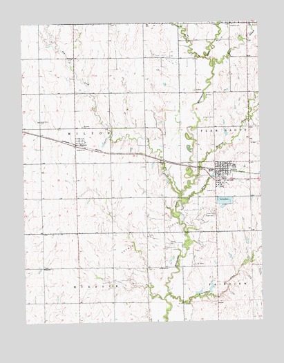
Potwin, KS USGS Topographic Map
Click on map above to begin viewing in our Map Viewer.

This topographic map contains these locations and features:
Feature Name Type Latitude Longitude GNIS ID View Map
1917 Community HouseParkN37.9396°W97.0192°2692630View Map
Bethel ChurchChurchN37.8978°W97.1150°473715View Map
BrainerdPopulated PlaceN37.9511°W97.0953°473721View Map
Brainerd CemeteryCemeteryN37.9567°W97.0935°473723View Map
Brush CreekStreamN37.9256°W97.0386°473714View Map
Cariboo (historical)LocaleN37.9208°W97.0828°482051View Map
City of PotwinCivilN37.9386°W97.0183°2396263View Map
Deer CreekStreamN37.9131°W97.0948°476682View Map
Diamond CreekStreamN37.9356°W97.0342°474381View Map
Dry CreekStreamN37.9275°W97.0431°473728View Map
East Branch Whitewater RiverStreamN37.9814°W97.0236°474382View Map
Emmaus Mennonite ChurchChurchN37.9852°W97.0985°473724View Map
First Christian ChurchChurchN37.9397°W97.0177°2689834View Map
First United Methodist Church of PotwinChurchN37.9393°W97.0216°2689414View Map
Fourmile CreekStreamN37.8864°W97.0503°474380View Map
Goldengate School (historical)SchoolN37.8972°W97.0545°473716View Map
Harder CemeteryCemeteryN37.9595°W97.1161°473722View Map
Henry CreekStreamN37.9853°W97.0284°473729View Map
Holderman CemeteryCemeteryN37.9990°W97.0133°473725View Map
McGill CemeteryCemeteryN37.9190°W97.0248°473718View Map
PotwinPopulated PlaceN37.9389°W97.0198°473720View Map
Potwin - Butler County Fire DepartmentBuildingN37.9399°W97.0205°2111741View Map
Potwin CemeteryCemeteryN37.9418°W97.0246°2673223View Map
Potwin City HallBuildingN37.9399°W97.0204°2693074View Map
Potwin Oil FieldOilfieldN37.9117°W97.0573°473719View Map
Potwin Post OfficePost OfficeN37.9382°W97.0198°2693925View Map
Potwin Public LibraryBuildingN37.9394°W97.0198°2694766View Map
Remington Elementary SchoolSchoolN37.9407°W97.0188°2497427View Map
Remington High SchoolSchoolN37.9551°W97.0947°2497500View Map
Shafer CemeteryCemeteryN37.9075°W97.0486°473717View Map
Swenson CreekStreamN37.9456°W97.0631°476683View Map
Township of MiltonCivilN37.9562°W97.0974°473727View Map

Note: Coordinates in the location and feature list above are referenced to NAD83 datum.


Copyright (C) 2008-2024 Ryan Niemi / Sunset Dynamics ... All Rights Reserved