TopoQuest Logo
Do you find TopoQuest useful?
Help keep TopoQuest running and adding new maps/features by donating!
Bitcoin:  19c7KJd3qBynnjoSw5npx9KScwjBe4ifkT
Litecoin:  LXs6TkuXGGXo1vDsWCkWVdjQX94eUKd6ui
Home View Maps Find Maps Find Places Resources & Links


Whitfield, Mississippi Topographic Map

USGS Map Title: Whitfield, MS
USGS Map MRC: 32090B1
DRG (GeoTIFF) Download: o32090b1.tif


Neighboring USGS Topographic Map Quads:


  Jackson, MS  
32090C2
 

  Jackson SE, MS  
32090C1
 

  Brandon, MS  
32089C8
 

  Florence, MS  
32090B2
 

  Whitfield, MS  
32090B1
 

  Puckett NW, MS  
32089B8
 

  Whites, MS  
32090A2
 

  Star, MS  
32090A1
 

  Braxton, MS  
32089A8


Map MRC Location:

N33°
W91°
N33°
W90°
H8 H7 H6 H5 H4 H3 H2 H1
G8 G7 G6 G5 G4 G3 G2 G1
F8 F7 F6 F5 F4 F3 F2 F1
E8 E7 E6 E5 E4 E3 E2 E1
D8 D7 D6 D5 D4 D3 D2 D1
C8 C7 C6 C5 C4 C3 C2 C1
B8 B7 B6 B5 B4 B3 B2 B1
A8 A7 A6 A5 A4 A3 A2 A1
N32°
W91°
N32°
W90°

Whitfield, MS USGS 1:24K Topographic Map Preview:
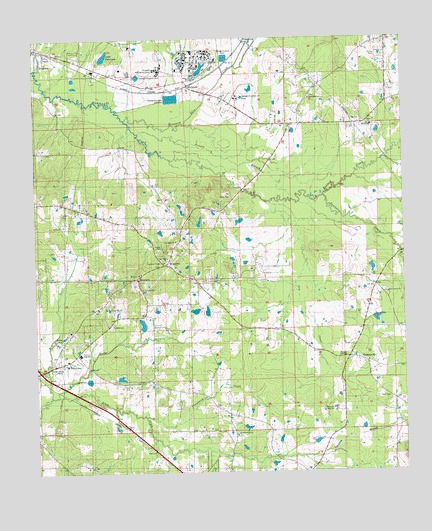
Whitfield, MS USGS Topographic Map
Click on map above to begin viewing in our Map Viewer.

This topographic map contains these locations and features:
Feature Name Type Latitude Longitude GNIS ID View Map
Bethel CemeteryCemeteryN32.2254°W90.0106°708990View Map
Bethel ChurchChurchN32.2249°W90.0104°666917View Map
Boteler LakeDamN32.1651°W90.0901°681041View Map
Briar Hill CemeteryCemeteryN32.1801°W90.0909°708995View Map
Briar Hill ChurchChurchN32.1807°W90.0901°667552View Map
Butler CreekStreamN32.1474°W90.1176°667860View Map
Central Mississippi Correctional FacilityBuildingN32.2295°W90.0589°2739790View Map
Central Mississippi Correctional Facility Fire DepartmentBuildingN32.2309°W90.0580°2668081View Map
City of FlorenceCivilN32.1556°W90.1224°2406503View Map
Compers Lake DamDamN32.1651°W90.0668°681040View Map
Creston Hill ChurchChurchN32.1560°W90.1201°668945View Map
Dry CreekStreamN32.2029°W90.0448°669435View Map
Dry Creek CemeteryCemeteryN32.1563°W90.0140°709024View Map
Ebeneezer Church (historical)ChurchN32.2199°W90.1098°690061View Map
Florence Fire Department Station 2BuildingN32.1556°W90.1081°2667964View Map
Florence High SchoolSchoolN32.1593°W90.1104°670047View Map
Good Hope ChurchChurchN32.1363°W90.0570°670474View Map
Goodhope CemeteryCemeteryN32.1354°W90.0576°709055View Map
GreenfieldPopulated PlaceN32.2493°W90.0529°691907View Map
Greenfield CemeteryCemeteryN32.2332°W90.0309°709057View Map
Greenfield ChurchChurchN32.2329°W90.0312°670688View Map
Greenfield School (historical)SchoolN32.2324°W90.0318°687041View Map
Howell (historical)Populated PlaceN32.2446°W90.1112°687047View Map
Hudspeth Retardation CenterHospitalN32.2410°W90.0834°690647View Map
Indian CreekStreamN32.1471°W90.1201°671679View Map
Jerusalem CemeteryCemeteryN32.1771°W90.0065°709065View Map
Jerusalem ChurchChurchN32.1765°W90.0054°671856View Map
Lake PattersonReservoirN32.2450°W90.1008°690663View Map
Linden (historical)Populated PlaceN32.1940°W90.0759°687053View Map
McLaurin High SchoolSchoolN32.1429°W90.0242°673393View Map
Mississippi Highway Patrol District 1 Troop CBuildingN32.2274°W90.0547°2754304View Map
Mississippi State HospitalHospitalN32.2425°W90.0704°673698View Map
Mississippi State Hospital Fire DepartmentBuildingN32.2443°W90.0709°2667969View Map
MontereyPopulated PlaceN32.1849°W90.0809°673735View Map
Monterey ChurchChurchN32.1824°W90.0893°673736View Map
Monterey Volunteer Fire DepartmentBuildingN32.1854°W90.0823°2667971View Map
New Hope CemeteryCemeteryN32.1907°W90.0770°709098View Map
New Hope ChurchChurchN32.1915°W90.0770°674692View Map
Norrell Plantation (historical)LocaleN32.2404°W90.1168°709101View Map
PatPopulated PlaceN32.1785°W90.0101°692130View Map
Patterson Lake DamDamN32.2451°W90.1001°681116View Map
PearsonPopulated PlaceN32.2468°W90.1231°675550View Map
Pringle BranchStreamN32.2229°W90.0893°676341View Map
Sand Hill School (historical)SchoolN32.2488°W90.0229°687089View Map
Sandhill CemeteryCemeteryN32.2418°W90.0187°709149View Map
Sandhill ChurchChurchN32.2421°W90.0184°709150View Map
Smith Lake DamDamN32.1701°W90.0734°681047View Map
Steens Creek Church (historical)ChurchN32.1565°W90.1195°687091View Map
Steepbank CreekStreamN32.1413°W90.0884°678266View Map
Steepbank School (historical)SchoolN32.1521°W90.0662°687092View Map
Terrapin Skin CreekStreamN32.2268°W90.0940°678636View Map
ThomasvillePopulated PlaceN32.1565°W90.0129°678689View Map
Thomasville Oil and Gas FieldOilfieldN32.1377°W90.0084°709164View Map
Tullos FieldAirportN32.1652°W90.0444°680335View Map
Tumbaloo CreekStreamN32.2026°W90.0354°678926View Map
Wesley CollegeSchoolN32.1563°W90.1145°690684View Map
WhitfieldPopulated PlaceN32.2354°W90.0720°679643View Map
Whitfield Lake DamDamN32.2418°W90.0668°681113View Map
Whitfield Lake DamDamN32.2485°W90.0768°681121View Map
Whitfield Post OfficePost OfficeN32.2414°W90.0697°2768775View Map
WMPR-FM (Jackson)TowerN32.1926°W90.0912°680209View Map

Note: Coordinates in the location and feature list above are referenced to NAD83 datum.


Copyright (C) 2008-2025 Ryan Niemi / Sunset Dynamics ... All Rights Reserved