TopoQuest Logo
Do you find TopoQuest useful?
Help keep TopoQuest running and adding new maps/features by donating!
Bitcoin:  19c7KJd3qBynnjoSw5npx9KScwjBe4ifkT
Litecoin:  LXs6TkuXGGXo1vDsWCkWVdjQX94eUKd6ui
Home View Maps Find Maps Find Places Resources & Links


Brandon, Mississippi Topographic Map

USGS Map Title: Brandon, MS
USGS Map MRC: 32089C8
DRG (GeoTIFF) Download: o32089c8.tif


Neighboring USGS Topographic Map Quads:


  Madison, MS  
32090D1
 

  Goshen Springs, MS  
32089D8
 

  Leesburg, MS  
32089D7
 

  Jackson SE, MS  
32090C1
 

  Brandon, MS  
32089C8
 

  Pelahatchie, MS  
32089C7
 

  Whitfield, MS  
32090B1
 

  Puckett NW, MS  
32089B8
 

  Johns, MS  
32089B7


Map MRC Location:

N33°
W90°
N33°
W89°
H8 H7 H6 H5 H4 H3 H2 H1
G8 G7 G6 G5 G4 G3 G2 G1
F8 F7 F6 F5 F4 F3 F2 F1
E8 E7 E6 E5 E4 E3 E2 E1
D8 D7 D6 D5 D4 D3 D2 D1
C8 C7 C6 C5 C4 C3 C2 C1
B8 B7 B6 B5 B4 B3 B2 B1
A8 A7 A6 A5 A4 A3 A2 A1
N32°
W90°
N32°
W89°

Brandon, MS USGS 1:24K Topographic Map Preview:
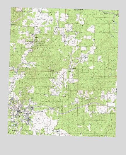
Brandon, MS USGS Topographic Map
Click on map above to begin viewing in our Map Viewer.

This topographic map contains these locations and features:
Feature Name Type Latitude Longitude GNIS ID View Map
Andrew ChapelChurchN32.3279°W89.9126°666267View Map
Andrew Chapel CemeteryCemeteryN32.3243°W89.9279°690630View Map
Blake Siding (historical)LocaleN32.2899°W89.9520°690055View Map
BrandonPopulated PlaceN32.2732°W89.9859°667519View Map
Brandon AcademySchoolN32.2701°W89.9767°687010View Map
Brandon CemeteryCemeteryN32.2813°W89.9945°708991View Map
Brandon Church of ChristChurchN32.2751°W89.9779°708992View Map
Brandon DepotLocaleN32.2863°W89.9940°667524View Map
Brandon Fire Department Station 2BuildingN32.2709°W89.9879°2667710View Map
Brandon High SchoolSchoolN32.2696°W89.9898°687011View Map
Brandon Lower Elementary SchoolSchoolN32.2707°W89.9898°687012View Map
Brandon Memory GardensCemeteryN32.2588°W89.9954°690634View Map
Brandon Middle SchoolSchoolN32.2807°W89.9973°687013View Map
Brandon Presbyterian ChurchChurchN32.2715°W89.9890°708993View Map
Brandon SpringsSpringN32.3038°W89.8956°687015View Map
Brandon Upper Elementary SchoolSchoolN32.2710°W89.9931°687016View Map
Brush CreekStreamN32.3696°W89.9204°667665View Map
Central Assembly ChurchChurchN32.2546°W89.9898°690636View Map
Central ChurchChurchN32.2982°W89.9473°690637View Map
Church of GodChurchN32.2771°W89.9929°709006View Map
City of BrandonCivilN32.2778°W89.9896°2403914View Map
Clear CreekStreamN32.3696°W89.8806°668562View Map
College BranchStreamN32.3251°W89.8809°668693View Map
Crossview Baptist ChurchChurchN32.2724°W89.9890°709019View Map
Devine SchoolSchoolN32.3579°W89.9740°669243View Map
Deweese SchoolSchoolN32.2571°W89.9540°669245View Map
EasthavenPopulated PlaceN32.2849°W89.9737°687034View Map
Evergreen CemeteryCemeteryN32.3179°W89.9279°709030View Map
Evergreen ChurchChurchN32.3163°W89.9281°669851View Map
Evergreen Fire Protection DistrictBuildingN32.3010°W89.9252°2667837View Map
Faith Presbyterian ChurchChurchN32.2763°W89.9967°709032View Map
First Baptist ChurchChurchN32.2704°W89.9890°709039View Map
First United Methodist Church of BrandonChurchN32.2718°W89.9859°709044View Map
Friendship CemeteryCemeteryN32.2581°W89.9540°709052View Map
Harrell Shopping CenterLocaleN32.2724°W89.9840°709059View Map
Holmes LakeLakeN32.3494°W89.8822°671354View Map
Interchange 59CrossingN32.2765°W89.9495°691386View Map
Jordan Grove CemeteryCemeteryN32.2960°W89.8845°709067View Map
Jordan Grove ChurchChurchN32.2957°W89.8845°690649View Map
Kennedy Lake DamDamN32.2585°W89.9451°681130View Map
LangfordPopulated PlaceN32.3465°W89.9723°672299View Map
Langford Volunteer Fire DepartmentBuildingN32.3462°W89.9723°2667783View Map
Meadow Grove Baptist ChurchChurchN32.2663°W89.9762°709080View Map
Mount Carmel CemeteryCemeteryN32.2757°W89.9059°673949View Map
Mount Carmel Church (historical)ChurchN32.2757°W89.9054°690071View Map
Mount Nebo ChurchChurchN32.3613°W89.9245°674092View Map
Mount Nebo Church (historical)ChurchN32.3607°W89.9237°690072View Map
New Friendship ChurchChurchN32.2579°W89.9545°690658View Map
Northwest Rankin High SchoolSchoolN32.3587°W89.9999°690661View Map
Oakdale CemeteryCemeteryN32.3487°W89.9820°709102View Map
Oakdale ChurchChurchN32.3485°W89.9742°690662View Map
Old Brandon CemeteryCemeteryN32.2757°W89.9926°709104View Map
Pilgrim Rest CemeteryCemeteryN32.3132°W89.9515°690669View Map
Pilgrims Rest ChurchChurchN32.3135°W89.9523°675772View Map
Pine Valley Baptist ChurchChurchN32.2826°W89.9898°709119View Map
RankinPopulated PlaceN32.2865°W89.9070°676471View Map
Rankin CountyCivilN32.2641°W89.9458°695781View Map
Rankin County CourthouseBuildingN32.2735°W89.9865°687078View Map
Rankin County Sheriff's OfficeBuildingN32.2745°W89.9858°2754221View Map
Reservoir Fire Department Station 2BuildingN32.3473°W89.9970°2667953View Map
Robin SchoolSchoolN32.2960°W89.8840°676718View Map
Rock Star Baptist ChurchChurchN32.2738°W89.9915°709141View Map
Saint Hill CemeteryCemeteryN32.3018°W89.9251°709143View Map
Saint Hill ChurchChurchN32.3015°W89.9251°690677View Map
Saint Luke Episcopal ChurchChurchN32.2738°W89.9890°709146View Map
Stevens Elementary SchoolSchoolN32.2718°W89.9898°687093View Map
Town West Shopping CenterLocaleN32.2746°W89.9945°709167View Map
Trickum Bridge (historical)BridgeN32.3557°W89.8787°690081View Map
True Vine CemeteryCemeteryN32.3569°W89.9728°709169View Map
True Vine CemeteryCemeteryN32.3573°W89.9748°2043053View Map
True Vine ChurchChurchN32.3571°W89.9726°690682View Map
ValuePopulated PlaceN32.2876°W89.9956°679180View Map
Williams CemeteryCemeteryN32.2740°W89.8987°690685View Map
WRKN-AM (Brandon)TowerN32.2890°W89.9973°680099View Map

Note: Coordinates in the location and feature list above are referenced to NAD83 datum.


Copyright (C) 2008-2024 Ryan Niemi / Sunset Dynamics ... All Rights Reserved