TopoQuest Logo
Do you find TopoQuest useful?
Help keep TopoQuest running and adding new maps/features by donating!
Bitcoin:  19c7KJd3qBynnjoSw5npx9KScwjBe4ifkT
Litecoin:  LXs6TkuXGGXo1vDsWCkWVdjQX94eUKd6ui
Home View Maps Find Maps Find Places Resources & Links


Star, Mississippi Topographic Map

USGS Map Title: Star, MS
USGS Map MRC: 32090A1
DRG (GeoTIFF) Download: o32090a1.tif


Neighboring USGS Topographic Map Quads:


  Florence, MS  
32090B2
 

  Whitfield, MS  
32090B1
 

  Puckett NW, MS  
32089B8
 

  Whites, MS  
32090A2
 

  Star, MS  
32090A1
 

  Braxton, MS  
32089A8
 

  Hopewell, MS  
31090H2
 

  Harrisville, MS  
31090H1
 

  Mendenhall West, MS  
31089H8


Map MRC Location:

N33°
W91°
N33°
W90°
H8 H7 H6 H5 H4 H3 H2 H1
G8 G7 G6 G5 G4 G3 G2 G1
F8 F7 F6 F5 F4 F3 F2 F1
E8 E7 E6 E5 E4 E3 E2 E1
D8 D7 D6 D5 D4 D3 D2 D1
C8 C7 C6 C5 C4 C3 C2 C1
B8 B7 B6 B5 B4 B3 B2 B1
A8 A7 A6 A5 A4 A3 A2 A1
N32°
W91°
N32°
W90°

Star, MS USGS 1:24K Topographic Map Preview:
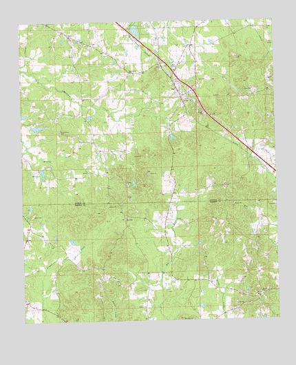
Star, MS USGS Topographic Map
Click on map above to begin viewing in our Map Viewer.

This topographic map contains these locations and features:
Feature Name Type Latitude Longitude GNIS ID View Map
AnsePopulated PlaceN32.1190°W90.1009°666281View Map
Belles Store (historical)LocaleN32.0735°W90.0890°687008View Map
Bishops Lake DamDamN32.0802°W90.1168°681004View Map
Campbellite CemeteryCemeteryN32.0876°W90.0034°708999View Map
Campbellite Church (historical)ChurchN32.0882°W90.0034°709000View Map
Comeby (historical)Populated PlaceN32.0696°W90.0098°687023View Map
Corley Lake DamDamN32.0835°W90.0901°681005View Map
Crenshaw Lake DamDamN32.0318°W90.1001°680986View Map
Dane (historical)Populated PlaceN32.1168°W90.0640°709020View Map
Enoch Grove CemeteryCemeteryN32.0793°W90.1059°669781View Map
Enoch Grove ChurchChurchN32.0852°W90.1081°687036View Map
Falcon FieldAirportN32.1121°W90.0453°680333View Map
Fridge Lake DamDamN32.0668°W90.1201°680998View Map
GamaPopulated PlaceN32.0224°W90.0918°685136View Map
Holly Grove Baptist ChurchChurchN32.0118°W90.0084°671318View Map
Holly Grove CemeteryCemeteryN32.0110°W90.0076°1959806View Map
Lake Shores Lake DamDamN32.1218°W90.0684°681016View Map
Middleton Field CemeteryCemeteryN32.0829°W90.0034°709082View Map
Morning Star CemeteryCemeteryN32.1065°W90.0537°709088View Map
Mount Salem ChurchChurchN32.0060°W90.0654°674259View Map
Mount Salem Church (historical)ChurchN32.0149°W90.0876°685158View Map
New Zion CemeteryCemeteryN32.0007°W90.0420°674863View Map
New Zion ChurchChurchN32.0002°W90.0423°674877View Map
Oak Hill School (historical)SchoolN32.1218°W90.0206°687064View Map
RexfordPopulated PlaceN32.0427°W90.0748°692174View Map
Rexford CemeteryCemeteryN32.0424°W90.0748°1959819View Map
Rexford Methodist ChurchChurchN32.0427°W90.0743°1959820View Map
Ridgway Management Lake DamDamN32.0552°W90.0784°680991View Map
Rockhill School (historical)SchoolN32.1007°W90.0056°687087View Map
Sardis School (historical)SchoolN32.0121°W90.1245°685180View Map
StarPopulated PlaceN32.0940°W90.0462°678222View Map
Star CemeteryCemeteryN32.1004°W90.0384°678223View Map
Star Post OfficePost OfficeN32.0976°W90.0452°2768826View Map
Star Volunteer Fire DepartmentBuildingN32.0938°W90.0451°2667965View Map
Wesleyanna CemeteryCemeteryN32.1035°W90.0726°679461View Map
Wesleyanna Church (historical)ChurchN32.1032°W90.0706°687100View Map

Note: Coordinates in the location and feature list above are referenced to NAD83 datum.


Copyright (C) 2008-2025 Ryan Niemi / Sunset Dynamics ... All Rights Reserved