TopoQuest Logo
Do you find TopoQuest useful?
Help keep TopoQuest running and adding new maps/features by donating!
Bitcoin:  19c7KJd3qBynnjoSw5npx9KScwjBe4ifkT
Litecoin:  LXs6TkuXGGXo1vDsWCkWVdjQX94eUKd6ui
Home View Maps Find Maps Find Places Resources & Links


Whittier, North Carolina Topographic Map

USGS Map Title: Whittier, NC
USGS Map MRC: 35083D3
DRG (GeoTIFF) Download: o35083d3.tif


Neighboring USGS Topographic Map Quads:


  Clingmans Dome, NC  
35083E4
 

  Smokemont, NC  
35083E3
 

  Bunches Bald, NC  
35083E2
 

  Bryson City, NC  
35083D4
 

  Whittier, NC  
35083D3
 

  Sylva North, NC  
35083D2
 

  Alarka, NC  
35083C4
 

  Greens Creek, NC  
35083C3
 

  Sylva South, NC  
35083C2


Map MRC Location:

N36°
W84°
N36°
W83°
H8 H7 H6 H5 H4 H3 H2 H1
G8 G7 G6 G5 G4 G3 G2 G1
F8 F7 F6 F5 F4 F3 F2 F1
E8 E7 E6 E5 E4 E3 E2 E1
D8 D7 D6 D5 D4 D3 D2 D1
C8 C7 C6 C5 C4 C3 C2 C1
B8 B7 B6 B5 B4 B3 B2 B1
A8 A7 A6 A5 A4 A3 A2 A1
N35°
W84°
N35°
W83°

Whittier, NC USGS 1:24K Topographic Map Preview:
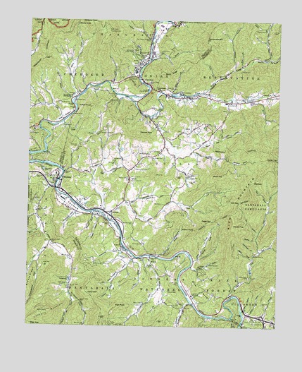
Whittier, NC USGS Topographic Map
Click on map above to begin viewing in our Map Viewer.

This topographic map contains these locations and features:
Feature Name Type Latitude Longitude GNIS ID View Map
Adams CreekStreamN35.4684°W83.3510°1008656View Map
Barkers CreekStreamN35.3854°W83.2924°1008924View Map
Beck BranchStreamN35.4248°W83.3274°1009093View Map
Bethabara ChurchChurchN35.4698°W83.3504°1009205View Map
Bethel CemeteryCemeteryN35.4673°W83.3301°1009211View Map
Big BranchStreamN35.4137°W83.2590°1009262View Map
Big Witch CreekStreamN35.4851°W83.2546°1009391View Map
BirdtownPopulated PlaceN35.4687°W83.3521°1019188View Map
Birdtown CemeteryCemeteryN35.4662°W83.3590°1009424View Map
Birdtown CommunityCivilN35.4769°W83.3605°2419313View Map
Bradley BranchStreamN35.4965°W83.2557°1009571View Map
Bradley CemeteryCemeteryN35.3904°W83.3032°1009573View Map
Buckeye BranchStreamN35.4109°W83.2601°1009756View Map
Bumgarner BranchStreamN35.4034°W83.3210°1009811View Map
Bumgarner CemeteryCemeteryN35.4037°W83.3251°1009812View Map
Cabe CoveValleyN35.4031°W83.2619°1009879View Map
Camp CreekStreamN35.4190°W83.3340°1009952View Map
Cane BranchStreamN35.4032°W83.3090°1009997View Map
Carter TopSummitN35.4435°W83.2505°1019547View Map
Cedar CliffSummitN35.3882°W83.3444°1019569View Map
CherokeePopulated PlaceN35.4743°W83.3149°1019613View Map
Cherokee Census Designated PlaceCensusN35.4860°W83.3011°2629369View Map
Cherokee ChurchChurchN35.4668°W83.2749°1010195View Map
Cherokee Fire DepartmentBuildingN35.4874°W83.3140°2639809View Map
Cherokee Fire Department Station 2BuildingN35.4601°W83.2772°2638671View Map
Cherokee GapGapN35.4718°W83.3107°1010196View Map
Cherokee Indian HospitalHospitalN35.4849°W83.3234°2701495View Map
Cherokee Indian Reservation (historical)CivilN35.4987°W83.2576°1023778View Map
Cherokee Police DepartmentBuildingN35.4824°W83.3189°2769660View Map
Cherokee Post OfficePost OfficeN35.4856°W83.3158°2766607View Map
Cherokee Tribal Emergency Medical ServicesBuildingN35.4903°W83.3129°2720721View Map
Chestnut Cove CreekStreamN35.3868°W83.3524°1010235View Map
Connelly CreekStreamN35.4320°W83.3607°1027393View Map
Connelly Creek ChurchChurchN35.3923°W83.3532°1027394View Map
Connelly MountainSummitN35.3808°W83.3652°1019757View Map
Copper CemeteryCemeteryN35.4854°W83.3193°1010478View Map
Cowee TunnelTunnelN35.3773°W83.2693°1010527View Map
Crooked CreekStreamN35.4215°W83.3377°1010588View Map
Deep GapGapN35.3759°W83.3729°1010755View Map
Deep Gap BranchStreamN35.3751°W83.3585°1010757View Map
Denton CoveValleyN35.3963°W83.3293°1010786View Map
Dicks CreekStreamN35.3870°W83.2724°1010808View Map
Dicks CreekLocaleN35.4023°W83.2626°1023558View Map
Dicks Creek CemeteryCemeteryN35.3956°W83.2638°1010809View Map
Dicks Creek ChurchChurchN35.4043°W83.2610°1010810View Map
Double TopSummitN35.4163°W83.2717°1020013View Map
East Fork Dicks CreekStreamN35.4059°W83.2579°1010986View Map
Eastern Cherokee ReservationCivilN35.4785°W83.2722°1018039View Map
Franklin CemeteryCemeteryN35.3773°W83.2618°1011376View Map
FrontierlandParkN35.4698°W83.2977°1011400View Map
GatewayLocaleN35.4223°W83.3321°1011453View Map
Gibbs BranchStreamN35.4584°W83.3574°1011474View Map
Gibson CoveValleyN35.4101°W83.3017°1011484View Map
Gibson KnobSummitN35.4143°W83.2922°1020427View Map
Goose CreekStreamN35.4573°W83.3613°1011565View Map
Gunter CemeteryCemeteryN35.4362°W83.2940°1011777View Map
Hazel HollowValleyN35.3816°W83.2667°1011946View Map
Hensley CemeteryCemeteryN35.4001°W83.3140°1011976View Map
High PointSummitN35.3831°W83.3304°1020753View Map
Holcomb CoveValleyN35.4062°W83.3279°1012118View Map
Homer Burgess DamDamN35.4468°W83.3299°1017207View Map
Homer Burgess LakeReservoirN35.4474°W83.3282°1017206View Map
Hoot Owl CoveValleyN35.4479°W83.2923°1012163View Map
Hyatt CemeteryCemeteryN35.4484°W83.2996°1012316View Map
Hyatt Chapel ChurchChurchN35.4362°W83.2946°1012317View Map
Improvement CoveValleyN35.4020°W83.3692°1012326View Map
Improvement CreekStreamN35.4037°W83.3682°1017949View Map
Indian HillsPopulated PlaceN35.4601°W83.3152°1023557View Map
Jacks CreekStreamN35.4020°W83.2918°1012403View Map
Jenkins CoveValleyN35.3991°W83.2923°1012458View Map
Jericho CoveValleyN35.4443°W83.2760°1012466View Map
Joe BranchStreamN35.3923°W83.3079°1012485View Map
Jones CemeteryCemeteryN35.4006°W83.3665°1012547View Map
Kitchen CoveValleyN35.4203°W83.3423°1012643View Map
Lambert BranchStreamN35.4923°W83.3127°1012667View Map
Lambert CemeteryCemeteryN35.4876°W83.3090°1012668View Map
Laurel BranchStreamN35.3787°W83.2721°1012713View Map
Lewis CoveValleyN35.4197°W83.3401°1012835View Map
Log Cabin SchoolSchoolN35.3879°W83.2915°1013076View Map
Long BranchStreamN35.4682°W83.2671°1013114View Map
Long BranchStreamN35.3798°W83.2660°1013136View Map
Long Branch ChurchChurchN35.3773°W83.2615°1013146View Map
Low GapGapN35.4262°W83.2690°1013222View Map
Macedonia ChurchChurchN35.4704°W83.2543°1013280View Map
Mainey BranchStreamN35.4987°W83.2549°1013295View Map
McCoy BranchStreamN35.4665°W83.3532°1013407View Map
Mince BranchStreamN35.3801°W83.2635°1013603View Map
Mink BranchStreamN35.4815°W83.2679°1013620View Map
Moore BranchStreamN35.4148°W83.3682°1013678View Map
Mount Noble Lookout TowerTowerN35.4962°W83.3332°1023667View Map
Mountainside TheaterLocaleN35.4868°W83.3199°1013808View Map
Nations CemeteryCemeteryN35.3845°W83.3160°1013878View Map
Nations CreekStreamN35.4040°W83.3138°1013879View Map
Ned BranchStreamN35.4262°W83.2546°1013888View Map
Ned GapGapN35.4348°W83.2615°1013890View Map
Nick BottomBendN35.4601°W83.3577°1013958View Map
O'Dear KnobSummitN35.4644°W83.3444°1021681View Map
Oconaluftee Indian VillagePopulated PlaceN35.4868°W83.3227°1021717View Map
Oconaluftee LakeReservoirN35.4451°W83.3749°1017205View Map
Old Campground CemeteryCemeteryN35.4448°W83.3138°1014091View Map
OlivetPopulated PlaceN35.4545°W83.2965°1021746View Map
Our Lady of Guadalupe ChurchChurchN35.4929°W83.3140°1014148View Map
Owl BranchStreamN35.4745°W83.3343°1014156View Map
Owl BranchStreamN35.4829°W83.3146°1014157View Map
Owl CemeteryCemeteryN35.4270°W83.3718°1014158View Map
Paint TownPopulated PlaceN35.4693°W83.2927°1021782View Map
Painttown CommunityCivilN35.4756°W83.2907°2419046View Map
Patterson Chapel ChurchChurchN35.4545°W83.3382°1014257View Map
Peggy GapGapN35.4179°W83.2829°1014305View Map
Pine RidgeRidgeN35.3890°W83.2847°1014435View Map
QuallaPopulated PlaceN35.4354°W83.3229°1022118View Map
Qualla Housing ProjectLocaleN35.4579°W83.2857°1014678View Map
Qualla Volunteer Fire Department Station 1BuildingN35.4351°W83.3247°2638524View Map
Qualla Volunteer Fire Department Station 2BuildingN35.3987°W83.2927°2639115View Map
Rattlesnake MountainSummitN35.4926°W83.2863°1014755View Map
Reagan CemeteryCemeteryN35.4440°W83.3068°1014776View Map
Rich MountainSummitN35.4274°W83.2638°1022265View Map
Robinson CemeteryCemeteryN35.3845°W83.2568°1014970View Map
Rock Hill ChurchChurchN35.4568°W83.3574°1014998View Map
Rock Springs ChurchChurchN35.4707°W83.2879°993528View Map
Rocky BranchStreamN35.4023°W83.3213°1015020View Map
Rocky KnobSummitN35.4981°W83.3450°1022354View Map
Saint Francis of Assisi ChurchChurchN35.4768°W83.3202°1015155View Map
Santa's LandParkN35.4679°W83.2638°1015247View Map
Schoolhouse BranchStreamN35.4051°W83.2607°1015322View Map
Sherrill CemeteryCemeteryN35.4501°W83.2904°1015427View Map
Shoal CreekStreamN35.4607°W83.3135°1015451View Map
Shoal Creek ChurchChurchN35.4348°W83.3227°1015458View Map
Shoal Creek ChurchChurchN35.4359°W83.3235°1015459View Map
Shuler CoveValleyN35.4026°W83.2897°1015498View Map
Smoky Mountain Elementary SchoolSchoolN35.4348°W83.3249°1017581View Map
Sneed CemeteryCemeteryN35.4720°W83.3054°1015636View Map
Soco Community CenterLocaleN35.4698°W83.2504°1015665View Map
Soco CreekStreamN35.4689°W83.3255°1015666View Map
Spray RidgeRidgeN35.4792°W83.3088°1015736View Map
Stamper CemeteryCemeteryN35.4798°W83.2688°1015785View Map
Stillwell BranchStreamN35.4698°W83.3052°1015851View Map
Swimmer BranchStreamN35.4807°W83.2715°1015996View Map
Thomas CemeteryCemeteryN35.4354°W83.3249°1016105View Map
Thomas CoveValleyN35.4208°W83.3511°1016110View Map
Thomas PeakSummitN35.4538°W83.3200°1022938View Map
Thomas ValleyValleyN35.4313°W83.3601°1016112View Map
Till CoveValleyN35.3950°W83.3316°1016145View Map
Tolley CemeteryCemeteryN35.4720°W83.3035°1016170View Map
Tom Nations CemeteryCemeteryN35.3834°W83.2993°1016182View Map
Tooni BranchStreamN35.4757°W83.2815°1016193View Map
Township of Barkers CreekCivilN35.3941°W83.2846°1026828View Map
Township of QuallaCivilN35.4643°W83.2517°1026837View Map
Tuc-a-way LakeReservoirN35.4390°W83.3674°1016246View Map
Union Hill CemeteryCemeteryN35.4484°W83.3501°1016322View Map
Ward CemeteryCemeteryN35.4254°W83.3076°1016438View Map
Water Falls ChurchChurchN35.4848°W83.2607°1016458View Map
Welch TopSummitN35.4362°W83.2773°1023151View Map
Wesser CreekStreamN35.4093°W83.3632°1016517View Map
West Fork Dicks CreekStreamN35.4057°W83.2579°1016535View Map
Whiteoak FlatsGapN35.4990°W83.3418°1016618View Map
WhittierPopulated PlaceN35.4351°W83.3602°1016645View Map
Whittier Elementary SchoolSchoolN35.4370°W83.3610°1017361View Map
Whittier Post OfficePost OfficeN35.4347°W83.3584°2766620View Map
Williams BranchStreamN35.4009°W83.3715°1016699View Map
WilmotPopulated PlaceN35.4023°W83.3129°1023270View Map
Worley Chapel CemeteryCemeteryN35.4165°W83.3224°1016836View Map
Wrights CreekStreamN35.4704°W83.2888°1016847View Map
Wrights Creek ChurchChurchN35.4965°W83.2563°1016848View Map
Yellow Hill ChurchChurchN35.4854°W83.3104°1016866View Map
Yellowhill CommunityCivilN35.4935°W83.3095°2419335View Map

Note: Coordinates in the location and feature list above are referenced to NAD83 datum.


Copyright (C) 2008-2024 Ryan Niemi / Sunset Dynamics ... All Rights Reserved