TopoQuest Logo
Do you find TopoQuest useful?
Help keep TopoQuest running and adding new maps/features by donating!
Bitcoin:  19c7KJd3qBynnjoSw5npx9KScwjBe4ifkT
Litecoin:  LXs6TkuXGGXo1vDsWCkWVdjQX94eUKd6ui
Home View Maps Find Maps Find Places Resources & Links


Whitworth Ranch, Texas Topographic Map

USGS Map Title: Whitworth Ranch, TX
USGS Map MRC: 30098A6
DRG (GeoTIFF) Download: o30098a6.tif


Neighboring USGS Topographic Map Quads:


  Cain City, TX  
30098B7
 

  Stonewall, TX  
30098B6
 

  Hye, TX  
30098B5
 

  Rafter Hollow, TX  
30098A7
 

  Whitworth Ranch, TX  
30098A6
 

  Crabapple Creek, TX  
30098A5
 

  Waring, TX  
29098H7
 

  Sisterdale, TX  
29098H6
 

  Kendalia, TX  
29098H5


Map MRC Location:

N31°
W99°
N31°
W98°
H8 H7 H6 H5 H4 H3 H2 H1
G8 G7 G6 G5 G4 G3 G2 G1
F8 F7 F6 F5 F4 F3 F2 F1
E8 E7 E6 E5 E4 E3 E2 E1
D8 D7 D6 D5 D4 D3 D2 D1
C8 C7 C6 C5 C4 C3 C2 C1
B8 B7 B6 B5 B4 B3 B2 B1
A8 A7 A6 A5 A4 A3 A2 A1
N30°
W99°
N30°
W98°

Whitworth Ranch, TX USGS 1:24K Topographic Map Preview:
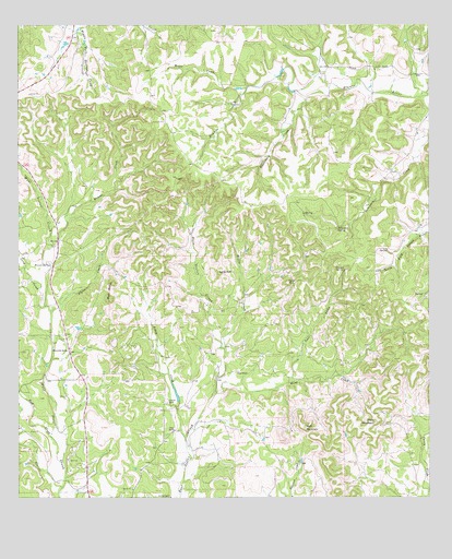
Whitworth Ranch, TX USGS Topographic Map
Click on map above to begin viewing in our Map Viewer.

This topographic map contains these locations and features:
Feature Name Type Latitude Longitude GNIS ID View Map
Askey CreekStreamN30.0102°W98.6978°1329808View Map
Blackberry CreekStreamN30.1060°W98.6623°1330791View Map
Bust ButtesSummitN30.0527°W98.7223°1331741View Map
Carson SpringSpringN30.0604°W98.6510°1332210View Map
Cave HillSummitN30.0569°W98.6681°1332357View Map
Comfort DivisionCivilN30.0129°W98.7008°1938641View Map
Comfort Historical SocietyBuildingN30.0266°W98.7375°2014540View Map
Cothrum RanchLocaleN30.0258°W98.7048°1333404View Map
Delaware SpringSpringN30.0713°W98.6531°1334239View Map
Diamond K Ranch AirportAirportN30.0366°W98.6975°1386406View Map
Haag CreekStreamN30.0277°W98.6906°1337168View Map
Haag RanchLocaleN30.0335°W98.6836°1337169View Map
Headwaters AirportAirportN30.0983°W98.7046°2675789View Map
Jung CreekStreamN30.0508°W98.7417°1338926View Map
LindendalePopulated PlaceN30.1119°W98.6320°2034999View Map
Lone HillSummitN30.0594°W98.6895°1340369View Map
Meier CreekStreamN30.1085°W98.6803°1341343View Map
Meta MountainSummitN30.0199°W98.6417°1341429View Map
Offer RanchLocaleN30.0183°W98.7025°1343074View Map
Platte CreekStreamN30.0494°W98.7406°1344175View Map
Reeh CreekStreamN30.0097°W98.7373°1345007View Map
Sisterdale Valley DistrictParkN30.0002°W98.7059°2031878View Map
Soell CreekStreamN30.0305°W98.6681°1347356View Map
Wenzel CreekStreamN30.0666°W98.7398°1349651View Map
Wenzel SpringSpringN30.0616°W98.7403°1349652View Map
Whitworth RanchLocaleN30.0388°W98.7353°1350034View Map
Willie CreekStreamN30.0394°W98.6875°1350160View Map
Wolf MountainSummitN30.0185°W98.6628°1350478View Map

Note: Coordinates in the location and feature list above are referenced to NAD83 datum.


Copyright (C) 2008-2025 Ryan Niemi / Sunset Dynamics ... All Rights Reserved