TopoQuest Logo
Do you find TopoQuest useful?
Help keep TopoQuest running and adding new maps/features by donating!
Bitcoin:  19c7KJd3qBynnjoSw5npx9KScwjBe4ifkT
Litecoin:  LXs6TkuXGGXo1vDsWCkWVdjQX94eUKd6ui
Home View Maps Find Maps Find Places Resources & Links


Willard, Missouri Topographic Map

USGS Map Title: Willard, MO
USGS Map MRC: 37093C4
DRG (GeoTIFF) Download: o37093c4.tif


Neighboring USGS Topographic Map Quads:


  Walnut Grove, MO  
37093D5
 

  Morrisville, MO  
37093D4
 

  Pleasant Hope, MO  
37093D3
 

  Ash Grove, MO  
37093C5
 

  Willard, MO  
37093C4
 

  Ebenezer, MO  
37093C3
 

  Halltown NE, MO  
37093B5
 

  Brookline, MO  
37093B4
 

  Springfield, MO  
37093B3


Map MRC Location:

N38°
W94°
N38°
W93°
H8 H7 H6 H5 H4 H3 H2 H1
G8 G7 G6 G5 G4 G3 G2 G1
F8 F7 F6 F5 F4 F3 F2 F1
E8 E7 E6 E5 E4 E3 E2 E1
D8 D7 D6 D5 D4 D3 D2 D1
C8 C7 C6 C5 C4 C3 C2 C1
B8 B7 B6 B5 B4 B3 B2 B1
A8 A7 A6 A5 A4 A3 A2 A1
N37°
W94°
N37°
W93°

Willard, MO USGS 1:24K Topographic Map Preview:
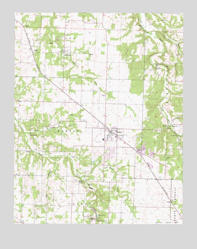
Willard, MO USGS Topographic Map
Click on map above to begin viewing in our Map Viewer.

This topographic map contains these locations and features:
Feature Name Type Latitude Longitude GNIS ID View Map
Big HollowValleyN37.2900°W93.4746°714178View Map
Bird FieldAirportN37.3187°W93.4199°2679406View Map
Brower SpringSpringN37.2756°W93.4500°714755View Map
Cave SpringPopulated PlaceN37.3514°W93.4635°735552View Map
Cave Spring Memorial ChurchChurchN37.3524°W93.4633°2564045View Map
Cave Spring Memorial Church CemeteryCemeteryN37.3524°W93.4631°2564044View Map
City of WillardCivilN37.2944°W93.4168°2397312View Map
Clear Creek CemeteryCemeteryN37.2539°W93.4452°715941View Map
Clear Creek ParkParkN37.2556°W93.4382°715945View Map
Clear Creek School (historical)SchoolN37.2542°W93.4491°732660View Map
Clear Creek SpringSpringN37.2521°W93.4393°715947View Map
Colored School (historical)SchoolN37.3506°W93.4627°732657View Map
Edgewood School (historical)SchoolN37.2548°W93.4113°732664View Map
Flat Rock School (historical)SchoolN37.2939°W93.4921°732659View Map
Flint Hill BranchStreamN37.3639°W93.3952°718026View Map
Friendship ChurchChurchN37.3428°W93.3955°718239View Map
HackneyPopulated PlaceN37.3450°W93.3955°732662View Map
Hackney Mill BridgeBridgeN37.3448°W93.3955°755198View Map
Johnson Ford BridgeBridgeN37.3667°W93.4046°755239View Map
Knox Ford BridgeBridgeN37.3028°W93.3785°755254View Map
Mount Pleasant BranchStreamN37.3037°W93.4927°722849View Map
Mount Pleasant ChurchChurchN37.3031°W93.4880°722861View Map
Murray CemeteryCemeteryN37.2873°W93.4380°723081View Map
PearlPopulated PlaceN37.3517°W93.4866°735772View Map
Rainer BranchStreamN37.2784°W93.4519°725078View Map
RitterPopulated PlaceN37.2637°W93.3838°725333View Map
Sneeds BridgeBridgeN37.3084°W93.3838°755407View Map
Star School (historical)SchoolN37.2539°W93.3838°732663View Map
Tatum ChapelChurchN37.2537°W93.4416°727480View Map
Textor AirportAirportN37.3655°W93.4962°2679405View Map
Township of MurrayCivilN37.3049°W93.4548°766687View Map
Wesley CemeteryCemeteryN37.3262°W93.4330°728513View Map
WillardPopulated PlaceN37.3050°W93.4285°735917View Map
Willard Fire Protection District Station 1BuildingN37.2994°W93.4321°2620388View Map
Willard Police DepartmentBuildingN37.2848°W93.4032°2752387View Map
Willard Post OfficePost OfficeN37.3071°W93.4323°2779527View Map
Willey School (historical)SchoolN37.3650°W93.4321°732661View Map
Yocum School (historical)SchoolN37.3234°W93.4969°732658View Map

Note: Coordinates in the location and feature list above are referenced to NAD83 datum.


Copyright (C) 2008-2025 Ryan Niemi / Sunset Dynamics ... All Rights Reserved