TopoQuest Logo
Do you find TopoQuest useful?
Help keep TopoQuest running and adding new maps/features by donating!
Bitcoin:  19c7KJd3qBynnjoSw5npx9KScwjBe4ifkT
Litecoin:  LXs6TkuXGGXo1vDsWCkWVdjQX94eUKd6ui
Home View Maps Find Maps Find Places Resources & Links


Brookline, Missouri Topographic Map

USGS Map Title: Brookline, MO
USGS Map MRC: 37093B4
DRG (GeoTIFF) Download: o37093b4.tif


Neighboring USGS Topographic Map Quads:


  Ash Grove, MO  
37093C5
 

  Willard, MO  
37093C4
 

  Ebenezer, MO  
37093C3
 

  Halltown NE, MO  
37093B5
 

  Brookline, MO  
37093B4
 

  Springfield, MO  
37093B3
 

  Billings, MO  
37093A5
 

  Republic, MO  
37093A4
 

  Nixa, MO  
37093A3


Map MRC Location:

N38°
W94°
N38°
W93°
H8 H7 H6 H5 H4 H3 H2 H1
G8 G7 G6 G5 G4 G3 G2 G1
F8 F7 F6 F5 F4 F3 F2 F1
E8 E7 E6 E5 E4 E3 E2 E1
D8 D7 D6 D5 D4 D3 D2 D1
C8 C7 C6 C5 C4 C3 C2 C1
B8 B7 B6 B5 B4 B3 B2 B1
A8 A7 A6 A5 A4 A3 A2 A1
N37°
W94°
N37°
W93°

Brookline, MO USGS 1:24K Topographic Map Preview:
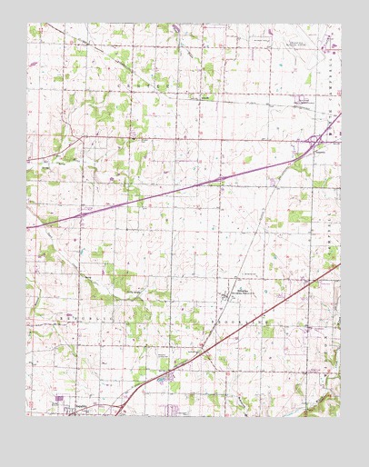
Brookline, MO USGS Topographic Map
Click on map above to begin viewing in our Map Viewer.

This topographic map contains these locations and features:
Feature Name Type Latitude Longitude GNIS ID View Map
Bennett School (historical)SchoolN37.2131°W93.4680°732683View Map
Beulah School (historical)SchoolN37.1398°W93.4163°732689View Map
Brewster ParkParkN37.2134°W93.4552°714678View Map
Brick School (historical)SchoolN37.1842°W93.4232°732687View Map
BrooklinePopulated PlaceN37.1634°W93.4202°735531View Map
Brookline CemeteryCemeteryN37.1703°W93.4144°714745View Map
Brookline Fire Protection District Station 1BuildingN37.1614°W93.4197°2621380View Map
Brookline Fire Protection District Station 2BuildingN37.1256°W93.4408°2620738View Map
Brookline Post OfficePost OfficeN37.1648°W93.4238°2782623View Map
Brookline School (historical)SchoolN37.1612°W93.4160°732690View Map
Center School (historical)SchoolN37.2137°W93.4182°732686View Map
Dailey SpringSpringN37.1648°W93.4545°716637View Map
ElwoodPopulated PlaceN37.2281°W93.4313°735599View Map
Evergreen CemeteryCemeteryN37.1267°W93.4741°717688View Map
Harrington CemeteryCemeteryN37.1262°W93.4355°719140View Map
HaseltinePopulated PlaceN37.2095°W93.3860°735641View Map
Jones School (historical)SchoolN37.1851°W93.4780°732684View Map
KSWM-AM (Republic)TowerN37.1498°W93.4124°759187View Map
Mount Aetna School (historical)SchoolN37.1478°W93.4707°732685View Map
Pleasant View Church (historical)ChurchN37.1481°W93.3757°732688View Map
Republic Fire Department Station 2 BrooklineBuildingN37.1697°W93.4211°2620692View Map
Rountree BranchStreamN37.1456°W93.3766°736029View Map
Sanford ParkParkN37.1456°W93.4307°726047View Map
Springfield-Branson National AirportAirportN37.2401°W93.3963°758955View Map
Township of BrooklineCivilN37.1483°W93.4173°766674View Map
Township of Center Number 1CivilN37.2342°W93.4278°766678View Map
Township of Republic NorthCivilN37.1547°W93.4610°1990073View Map
Township of West RepublicCivilN37.1504°W93.4977°766698View Map
White Chapel Memorial Gardens CemeteryCemeteryN37.2253°W93.3907°728725View Map
Willard Fire Protection District Station 3BuildingN37.2433°W93.4294°2620804View Map
Wyandotte School (historical)SchoolN37.2434°W93.4858°732682View Map
Yeakley (historical)Populated PlaceN37.2070°W93.4863°755663View Map

Note: Coordinates in the location and feature list above are referenced to NAD83 datum.


Copyright (C) 2008-2025 Ryan Niemi / Sunset Dynamics ... All Rights Reserved