TopoQuest Logo
Do you find TopoQuest useful?
Help keep TopoQuest running and adding new maps/features by donating!
Bitcoin:  19c7KJd3qBynnjoSw5npx9KScwjBe4ifkT
Litecoin:  LXs6TkuXGGXo1vDsWCkWVdjQX94eUKd6ui
Home View Maps Find Maps Find Places Resources & Links


Williamsburg, Ohio Topographic Map

USGS Map Title: Williamsburg, OH
USGS Map MRC: 39084A1
DRG (GeoTIFF) Download: o39084a1.tif


Neighboring USGS Topographic Map Quads:


  Goshen, OH  
39084B2
 

  Newtonsville, OH  
39084B1
 

  Fayetteville, OH  
39083B8
 

  Batavia, OH  
39084A2
 

  Williamsburg, OH  
39084A1
 

  Mount Orab, OH  
39083A8
 

  Laurel, OH  
38084H2
 

  Bethel, OH  
38084H1
 

  Hamersville, OH  
38083H8


Map MRC Location:

N40°
W85°
N40°
W84°
H8 H7 H6 H5 H4 H3 H2 H1
G8 G7 G6 G5 G4 G3 G2 G1
F8 F7 F6 F5 F4 F3 F2 F1
E8 E7 E6 E5 E4 E3 E2 E1
D8 D7 D6 D5 D4 D3 D2 D1
C8 C7 C6 C5 C4 C3 C2 C1
B8 B7 B6 B5 B4 B3 B2 B1
A8 A7 A6 A5 A4 A3 A2 A1
N39°
W85°
N39°
W84°

Williamsburg, OH USGS 1:24K Topographic Map Preview:
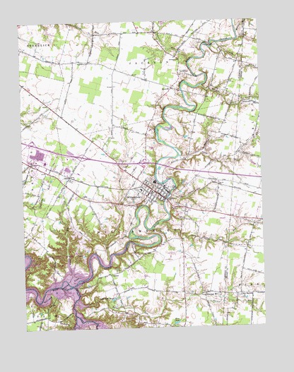
Williamsburg, OH USGS Topographic Map
Click on map above to begin viewing in our Map Viewer.

This topographic map contains these locations and features:
Feature Name Type Latitude Longitude GNIS ID View Map
AftonPopulated PlaceN39.0615°W84.1002°1048448View Map
Afton Post Office (historical)Post OfficeN39.0612°W84.0999°1966258View Map
Alpine School (historical)SchoolN39.0790°W84.0602°1054092View Map
Antibantam School (historical)SchoolN39.0051°W84.1144°1054100View Map
Barnes RunStreamN39.0101°W84.0897°1083965View Map
BlowvillePopulated PlaceN39.0976°W84.0449°1062652View Map
Blowville Post Office (historical)Post OfficeN39.0973°W84.0444°1985332View Map
Blue Sky ParkParkN39.1159°W84.0269°1038149View Map
Cabin RunStreamN39.0195°W84.1024°1038593View Map
Clover School (historical)SchoolN39.0073°W84.0413°1054090View Map
Cloverlick CreekStreamN39.0176°W84.0997°1085459View Map
ConcordPopulated PlaceN39.0220°W84.0802°1039290View Map
Concord CemeteryCemeteryN39.0239°W84.0744°1963140View Map
Corner School (historical)SchoolN39.0765°W84.0885°1054098View Map
Crane RunStreamN39.0695°W84.0413°1039453View Map
CrosstownPopulated PlaceN39.0917°W84.0060°1039497View Map
Crosstown Post Office (historical)Post OfficeN39.0917°W84.0055°1965630View Map
De La Palma School (historical)SchoolN39.0706°W84.0116°1053051View Map
Dela Pama Fishing LakeReservoirN39.0584°W84.0433°1079342View Map
Dela Pama Fishing Lake DamDamN39.0584°W84.0433°1079341View Map
East Fork State ParkParkN39.0301°W84.1041°1085183View Map
East Fork Wildlife AreaParkN39.0328°W84.0647°1054096View Map
Fivemile CreekStreamN39.1134°W84.0244°1040488View Map
Fourmile CreekStreamN39.0987°W84.0299°1040619View Map
Greenberry ChurchChurchN39.1090°W84.0410°1041116View Map
Greenberry School (historical)SchoolN39.1095°W84.0413°1054091View Map
Harbough School (historical)SchoolN39.1084°W84.0108°1054088View Map
Hennings MillPopulated PlaceN39.0142°W84.0305°1041490View Map
Hennings Mill Post Office (historical)Post OfficeN39.0140°W84.0305°1966111View Map
Howard RunStreamN39.1198°W84.0108°1041832View Map
Kain RunStreamN39.0295°W84.0799°1042171View Map
Kain Run School (historical)SchoolN39.0328°W84.0872°1054099View Map
Lake O' the WoodsLakeN39.0119°W84.0788°1044020View Map
Maple Grove ChurchChurchN39.1084°W84.0885°1042953View Map
Maple Grove School (historical)SchoolN39.1090°W84.0888°1054097View Map
McKeever School (historical)SchoolN39.0840°W84.0185°1054089View Map
Mims LakeReservoirN39.0018°W84.0463°1043395View Map
New HarmonyPopulated PlaceN39.0137°W84.0122°1049008View Map
New Harmony CemeteryCemeteryN39.0151°W84.0080°1699137View Map
New Harmony Post Office (historical)Post OfficeN39.0140°W84.0124°1965843View Map
Pleasant RunStreamN39.1078°W84.0366°1044579View Map
Poplar CreekStreamN39.0051°W84.0988°1066906View Map
Riveredge Country ClubLocaleN39.1034°W84.0402°1080177View Map
School Number 7 (historical)SchoolN39.0165°W84.0127°1730808View Map
Sixmile CreekStreamN39.1178°W84.0099°1066962View Map
Stonelick Township Fire and Rescue Station 1BuildingN39.1230°W84.1235°2550492View Map
Todd RunStreamN39.0428°W84.0547°1067014View Map
Todd Run School (historical)SchoolN39.0373°W84.0430°1054095View Map
Township of WilliamsburgCivilN39.0405°W84.0618°1085875View Map
Twin BridgesBridgeN39.0178°W84.0988°1048380View Map
Village of WilliamsburgCivilN39.0448°W84.0569°2400171View Map
William H Harsha LakeReservoirN39.0132°W84.1149°1048404View Map
WilliamsburgPopulated PlaceN39.0542°W84.0530°1061782View Map
Williamsburg Branch Clermont County Public LibraryBuildingN39.0565°W84.0572°1806887View Map
Williamsburg CemeteryCemeteryN39.0612°W84.0577°1963167View Map
Williamsburg Church of ChristChurchN39.0595°W84.0622°1065557View Map
Williamsburg Elementary SchoolSchoolN39.0562°W84.0630°1054093View Map
Williamsburg High SchoolSchoolN39.0556°W84.0574°1054094View Map
Williamsburg Post OfficePost OfficeN39.0542°W84.0527°1966279View Map
Williamsburg Presbyterian ChurchChurchN39.0381°W84.0508°1052077View Map
Williamsburg Township Emergency ServicesBuildingN39.0589°W84.0631°2550158View Map
Williamsburg United Methodist ChurchChurchN39.0562°W84.0522°1052076View Map
Williamsburg Village PoliceBuildingN39.0526°W84.0513°2732556View Map
WOBO-FM (Batavia)TowerN39.0620°W84.0972°1085312View Map

Note: Coordinates in the location and feature list above are referenced to NAD83 datum.


Copyright (C) 2008-2024 Ryan Niemi / Sunset Dynamics ... All Rights Reserved