TopoQuest Logo
Do you find TopoQuest useful?
Help keep TopoQuest running and adding new maps/features by donating!
Bitcoin:  19c7KJd3qBynnjoSw5npx9KScwjBe4ifkT
Litecoin:  LXs6TkuXGGXo1vDsWCkWVdjQX94eUKd6ui
Home View Maps Find Maps Find Places Resources & Links


Wilson Mountain, Arizona Topographic Map

USGS Map Title: Wilson Mountain, AZ
USGS Map MRC: 34111H7
DRG (GeoTIFF) Download: o34111h7.tif


Neighboring USGS Topographic Map Quads:


  Sycamore Point, AZ  
35111A8
 

  Dutton Hill, AZ  
35111A7
 

  Mountainaire, AZ  
35111A6
 

  Loy Butte, AZ  
34111H8
 

  Wilson Mountain, AZ  
34111H7
 

  Munds Park, AZ  
34111H6
 

  Page Springs, AZ  
34111G8
 

  Sedona, AZ  
34111G7
 

  Munds Mountain, AZ  
34111G6


Map MRC Location:

N35°
W112°
N35°
W111°
H8 H7 H6 H5 H4 H3 H2 H1
G8 G7 G6 G5 G4 G3 G2 G1
F8 F7 F6 F5 F4 F3 F2 F1
E8 E7 E6 E5 E4 E3 E2 E1
D8 D7 D6 D5 D4 D3 D2 D1
C8 C7 C6 C5 C4 C3 C2 C1
B8 B7 B6 B5 B4 B3 B2 B1
A8 A7 A6 A5 A4 A3 A2 A1
N34°
W112°
N34°
W111°

Wilson Mountain, AZ USGS 1:24K Topographic Map Preview:
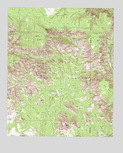
Wilson Mountain, AZ USGS Topographic Map
Click on map above to begin viewing in our Map Viewer.

This topographic map contains these locations and features:
Feature Name Type Latitude Longitude GNIS ID View Map
AM TankReservoirN34.9572°W111.8406°2090068View Map
Banjo Bill CampgroundLocaleN34.9614°W111.7532°25946View Map
Barney PastureAreaN34.9925°W111.8221°25992View Map
Barney Pasture BurnAreaN34.9925°W111.8168°37630View Map
Barney SpringSpringN34.9935°W111.8093°25994View Map
Bear Sign CanyonValleyN34.9453°W111.7949°26103View Map
Bootlegger CampgroundLocaleN34.9689°W111.7508°2515354View Map
Boynton CanyonValleyN34.8914°W111.8382°26699View Map
Boynton PassGapN34.8975°W111.8613°26700View Map
Bridle TrailTrailN34.8886°W111.7579°26739View Map
Brins MesaSummitN34.9083°W111.7729°26744View Map
Buckhead PointCliffN34.9967°W111.7804°26904View Map
Buckhead RidgeRidgeN34.9967°W111.7963°26905View Map
Buckshead TankReservoirN34.9894°W111.7811°2090061View Map
Burn TankReservoirN34.9864°W111.8541°27018View Map
Capitol ButteSummitN34.8861°W111.8068°27279View Map
Chimney RockSummitN34.8772°W111.8127°27591View Map
Coffeepot RockSummitN34.8845°W111.7918°27786View Map
Crater TankReservoirN34.9864°W111.8236°2090065View Map
Devils BridgeArchN34.8976°W111.8075°28435View Map
Devils KitchenAreaN34.8861°W111.7824°28444View Map
Doe MountainSummitN34.8903°W111.8607°28512View Map
Earls TankReservoirN34.9209°W111.8127°28730View Map
East PocketBasinN34.9661°W111.7738°28782View Map
East Pocket KnobSummitN34.9756°W111.7685°28783View Map
East Pocket Lookout TowerTowerN34.9756°W111.7685°37770View Map
East Pocket TankReservoirN34.9684°W111.7708°28784View Map
Fay CanyonValleyN34.8803°W111.8432°28962View Map
Fay Canyon ArchArchN34.9095°W111.8608°28964View Map
First TankReservoirN34.9847°W111.8078°2090063View Map
Grassy KnollsSummitN34.9109°W111.8218°29546View Map
H S CanyonValleyN34.9378°W111.8099°29647View Map
Halfway Picnic AreaParkN34.9567°W111.7549°29688View Map
Hancock Cabin TankReservoirN34.9911°W111.8119°2090064View Map
Indian Head ArchArchN34.9391°W111.7525°1678950View Map
Lil Round TankReservoirN34.9822°W111.8308°2090066View Map
Little Round MountainSummitN34.9689°W111.8357°31122View Map
Long CanyonValleyN34.8911°W111.8363°31226View Map
Lost Wilson MountainSummitN34.9289°W111.7793°31322View Map
Loy TankReservoirN34.9800°W111.7850°2090062View Map
Maroon MountainSummitN34.9433°W111.8413°31522View Map
Marshall TankReservoirN34.8920°W111.8739°31536View Map
Mescal MountainSummitN34.9095°W111.8390°31750View Map
Mos TankReservoirN34.9947°W111.8506°2090067View Map
OK TankReservoirN34.8980°W111.8309°32415View Map
Pine TankReservoirN34.9800°W111.7857°32982View Map
Rattlesnake MesaSummitN34.9886°W111.8727°33398View Map
Rattlesnake TankReservoirN34.9914°W111.8722°2090069View Map
Red Rock-Secret Mountain WildernessReserveN34.9509°W111.8420°44734View Map
Round Top MountainSummitN34.9697°W111.7965°38766View Map
Secret CanyonValleyN34.9300°W111.8074°34192View Map
Sedona-Oak Creek Golf CourseLocaleN34.9170°W111.8210°43210View Map
Side Rock CampgroundLocaleN34.9700°W111.7507°34407View Map
Slide Rock Swim AreaParkN34.9472°W111.7540°38076View Map
Soldier PassGapN34.9042°W111.7915°34624View Map
South PocketBasinN34.9697°W111.8529°34679View Map
South Pocket TankReservoirN34.9727°W111.8429°34680View Map
Steamboat RockSummitN34.8892°W111.7515°34809View Map
Sterling CanyonValleyN34.9370°W111.7960°34831View Map
Test Hole TankReservoirN34.8870°W111.7554°38868View Map
The CockscombSummitN34.8758°W111.8586°35218View Map
View PointCliffN34.9947°W111.7779°35783View Map
Vultee ArchArchN34.9416°W111.7688°35793View Map
Vultee Arch Twenty TwoTrailN34.9389°W111.7765°38144View Map
Wilson MountainSummitN34.9178°W111.7510°36290View Map
Wilson TankReservoirN34.9286°W111.7663°38187View Map

Note: Coordinates in the location and feature list above are referenced to NAD83 datum.


Copyright (C) 2008-2024 Ryan Niemi / Sunset Dynamics ... All Rights Reserved