TopoQuest Logo
Do you find TopoQuest useful?
Help keep TopoQuest running and adding new maps/features by donating!
Bitcoin:  19c7KJd3qBynnjoSw5npx9KScwjBe4ifkT
Litecoin:  LXs6TkuXGGXo1vDsWCkWVdjQX94eUKd6ui
Home View Maps Find Maps Find Places Resources & Links


Carrollton East, Missouri Topographic Map

USGS Map Title: Carrollton East, MO
USGS Map MRC: 39093C4
DRG (GeoTIFF) Download: o39093c4.tif


Neighboring USGS Topographic Map Quads:


  Bogard, MO  
39093D5
 

  Standish, MO  
39093D4
 

  Bosworth, MO  
39093D3
 

  Carrollton West, MO  
39093C5
 

  Carrollton East, MO  
39093C4
 

  Miami Station, MO  
39093C3
 

  Waverly, MO  
39093B5
 

  Grand Pass, MO  
39093B4
 

  Malta Bend, MO  
39093B3


Map MRC Location:

N40°
W94°
N40°
W93°
H8 H7 H6 H5 H4 H3 H2 H1
G8 G7 G6 G5 G4 G3 G2 G1
F8 F7 F6 F5 F4 F3 F2 F1
E8 E7 E6 E5 E4 E3 E2 E1
D8 D7 D6 D5 D4 D3 D2 D1
C8 C7 C6 C5 C4 C3 C2 C1
B8 B7 B6 B5 B4 B3 B2 B1
A8 A7 A6 A5 A4 A3 A2 A1
N39°
W94°
N39°
W93°

Carrollton East, MO USGS 1:24K Topographic Map Preview:
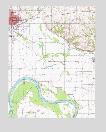
Carrollton East, MO USGS Topographic Map
Click on map above to begin viewing in our Map Viewer.

This topographic map contains these locations and features:
Feature Name Type Latitude Longitude GNIS ID View Map
Adams - Dieterich Elementary SchoolSchoolN39.3621°W93.4947°716893View Map
Adkins CemeteryCemeteryN39.3378°W93.3755°713154View Map
Anderson LakeReservoirN39.3716°W93.4582°761107View Map
Anderson Lake DamDamN39.3717°W93.4569°761106View Map
Bakers BendBendN39.2936°W93.4764°2109523View Map
Calvin (historical)LocaleN39.2567°W93.3833°740245View Map
Carroll County Sheriff's OfficeBuildingN39.3574°W93.4972°2752334View Map
CarrolltonPopulated PlaceN39.3584°W93.4958°715434View Map
Carrollton Area Career CenterSchoolN39.3705°W93.4899°2545330View Map
Carrollton Fire DepartmentBuildingN39.3647°W93.4824°2620384View Map
Carrollton High SchoolSchoolN39.3682°W93.4897°2545283View Map
Carrollton Junior High SchoolSchoolN39.3690°W93.4900°2545278View Map
Carrollton Post OfficePost OfficeN39.3594°W93.4973°2782643View Map
Cary SchoolSchoolN39.3386°W93.4558°715464View Map
City of CarrolltonCivilN39.3635°W93.4955°2393754View Map
Cooks LakeReservoirN39.3332°W93.4115°760872View Map
Cooks Lake DamDamN39.3334°W93.4102°760871View Map
Cottonwood BranchStreamN39.3689°W93.4558°716355View Map
Cox SchoolSchoolN39.2984°W93.4519°716434View Map
Cranberry BendBendN39.2706°W93.4497°2109533View Map
Cranberry ChuteLakeN39.2560°W93.4636°716459View Map
Famuliner Farms AirportAirportN39.2881°W93.3847°758979View Map
Hills BendBendN39.2656°W93.4064°2109535View Map
Hills Island ChuteGutN39.2614°W93.4100°2109534View Map
KMZU-FM (Carrollton)TowerN39.3681°W93.4947°754243View Map
KMZU-FM (Carrollton)TowerN39.3664°W93.4035°759123View Map
Little Wakenda CreekStreamN39.3278°W93.4074°721352View Map
Mayview SchoolSchoolN39.3553°W93.4383°722018View Map
Miller BranchStreamN39.3350°W93.4297°722370View Map
Riverside School (historical)SchoolN39.2545°W93.3869°746987View Map
Root Middle SchoolSchoolN39.3567°W93.4963°2545130View Map
Rosebud School (historical)SchoolN39.3484°W93.4119°746985View Map
Shields HillSummitN39.3372°W93.4158°726353View Map
South CarrolltonPopulated PlaceN39.3411°W93.4955°726707View Map
Standley BranchStreamN39.3461°W93.4916°727002View Map
Township of WakendaCivilN39.3154°W93.4753°766424View Map
WakendaPopulated PlaceN39.3142°W93.3772°730242View Map
Wakenda ChurchChurchN39.3697°W93.3835°728247View Map
Walnut Grove School (historical)SchoolN39.2917°W93.3969°746986View Map
Wayside School (historical)SchoolN39.3742°W93.4749°746984View Map
Whites IslandIslandN39.2714°W93.4730°728786View Map
Willis Chapel CemeteryCemeteryN39.3561°W93.4296°728916View Map

Note: Coordinates in the location and feature list above are referenced to NAD83 datum.


Copyright (C) 2008-2024 Ryan Niemi / Sunset Dynamics ... All Rights Reserved