TopoQuest Logo
Do you find TopoQuest useful?
Help keep TopoQuest running and adding new maps/features by donating!
Bitcoin:  19c7KJd3qBynnjoSw5npx9KScwjBe4ifkT
Litecoin:  LXs6TkuXGGXo1vDsWCkWVdjQX94eUKd6ui
Home View Maps Find Maps Find Places Resources & Links


Winnsboro, South Carolina Topographic Map

USGS Map Title: Winnsboro, SC
USGS Map MRC: 34081D1
DRG (GeoTIFF) Download: o34081d1.tif


Neighboring USGS Topographic Map Quads:


  Blackstock, SC  
34081E2
 

  Stover, SC  
34081E1
 

  Great Falls, SC  
34080E8
 

  Lebanon, SC  
34081D2
 

  Winnsboro, SC  
34081D1
 

  Flint Hill, SC  
34080D8
 

  Rion, SC  
34081C2
 

  Winnsboro Mills, SC  
34081C1
 

  Ridgeway, SC  
34080C8


Map MRC Location:

N35°
W82°
N35°
W81°
H8 H7 H6 H5 H4 H3 H2 H1
G8 G7 G6 G5 G4 G3 G2 G1
F8 F7 F6 F5 F4 F3 F2 F1
E8 E7 E6 E5 E4 E3 E2 E1
D8 D7 D6 D5 D4 D3 D2 D1
C8 C7 C6 C5 C4 C3 C2 C1
B8 B7 B6 B5 B4 B3 B2 B1
A8 A7 A6 A5 A4 A3 A2 A1
N34°
W82°
N34°
W81°

Winnsboro, SC USGS 1:24K Topographic Map Preview:
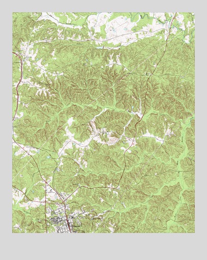
Winnsboro, SC USGS Topographic Map
Click on map above to begin viewing in our Map Viewer.

This topographic map contains these locations and features:
Feature Name Type Latitude Longitude GNIS ID View Map
Bethel Associate Reformed Presbyterian ChurchChurchN34.3813°W81.0851°1236986View Map
Bethesda African Methodist Episcopal Zion ChurchChurchN34.3838°W81.0926°1236989View Map
Bethlehem CemeteryCemeteryN34.4343°W81.0640°1248789View Map
Bethlehem ChurchChurchN34.4321°W81.0629°1245684View Map
Bethlehem School (historical)SchoolN34.4321°W81.0634°1236988View Map
Doctor Taylors Pond D-1570 DamDamN34.4535°W81.1131°1239013View Map
Fairfield CountyCivilN34.3951°W81.1212°1248000View Map
Fairfield County Emergency Medical ServicesBuildingN34.4037°W81.0984°2739540View Map
Fairfield County Fire Department Community SubstationBuildingN34.4192°W81.1117°2578300View Map
Fairfield County JailBuildingN34.3788°W81.0912°1237009View Map
Fairfield County LibraryBuildingN34.3826°W81.0876°1237010View Map
Fairfield County Training School (historical)SchoolN34.3835°W81.0934°1237012View Map
Fairfield County Vocational CenterSchoolN34.3996°W81.0984°1237011View Map
First Baptist ChurchChurchN34.3796°W81.0884°1237017View Map
Gaydens CreekStreamN34.4851°W81.0081°1222671View Map
Gordon SchoolSchoolN34.3835°W81.0979°1245786View Map
Gritts School (historical)SchoolN34.4099°W81.0204°1237024View Map
Holy Sanctified Baptist Church (historical)ChurchN34.3774°W81.0834°1237028View Map
Horse CreekStreamN34.4076°W81.0101°1223309View Map
Little Mission ChurchChurchN34.4026°W81.0793°1224019View Map
McCulley CreekStreamN34.4074°W81.0101°1224399View Map
Minton CreekStreamN34.4365°W81.0045°1224598View Map
Moore CreekStreamN34.3899°W81.1229°1224637View Map
Mount Olivet CemeteryCemeteryN34.4654°W81.0340°1248804View Map
Mount Olivet ChurchChurchN34.4649°W81.0337°1249638View Map
Mount Olivet School (historical)SchoolN34.4646°W81.0337°1237050View Map
Mount Zion InstituteSchoolN34.3838°W81.0834°1249736View Map
Oaklawn CemeteryCemeteryN34.3813°W81.0916°1248807View Map
Ready CreekStreamN34.4165°W81.0106°1237068View Map
Richard Winn AcademySchoolN34.4188°W81.0926°1237069View Map
Russell CemeteryCemeteryN34.3765°W81.0795°1226080View Map
Saint James CemeteryCemeteryN34.4782°W81.1209°1226104View Map
Saint John School (historical)SchoolN34.4393°W81.1240°1237079View Map
Saint Johns ChurchChurchN34.4396°W81.1237°1250557View Map
Saint Johns Episcopal ChurchChurchN34.3776°W81.0893°1237080View Map
Saint Paul Baptist ChurchChurchN34.3829°W81.0912°1237083View Map
Saint Pauls ChurchChurchN34.4651°W81.0429°1250670View Map
The Church of Jesus Christ of Latter Day SaintsChurchN34.3774°W81.0851°1237001View Map
Wall CreekStreamN34.4993°W81.0668°1227377View Map
Wateree Creek Watershed Structure Number FourReservoirN34.4801°W81.0649°1238698View Map
Wateree Creek WCD Dam Number Four D-0539DamN34.4801°W81.0631°1238697View Map
Weeping Mary ChurchChurchN34.4724°W81.1193°1251353View Map
White OakPopulated PlaceN34.4743°W81.1165°1231916View Map
White Oak BranchStreamN34.4465°W81.0876°1227542View Map
White Oak CemeteryCemeteryN34.4740°W81.1151°1248819View Map
White Oak ChurchChurchN34.4746°W81.1159°1251809View Map
White Oak Conference CenterLocaleN34.4876°W81.1081°1237104View Map
White Oak Conference Center LakeReservoirN34.4751°W81.0998°1239014View Map
White Oak Historic DistrictParkN34.4740°W81.1168°1237105View Map
WINF-AM (Winnsboro)TowerN34.3851°W81.0759°1252429View Map
WinnsboroPopulated PlaceN34.3807°W81.0865°1251474View Map
Winnsboro BranchStreamN34.3896°W81.1229°1251475View Map
Winnsboro Fire DepartmentBuildingN34.3801°W81.0875°2578642View Map
Winnsboro North DivisionCivilN34.4808°W81.1077°1938470View Map
Winnsboro Post OfficePost OfficeN34.3829°W81.0870°1252233View Map
Zion Church (historical)ChurchN34.4768°W81.1184°1242286View Map

Note: Coordinates in the location and feature list above are referenced to NAD83 datum.


Copyright (C) 2008-2025 Ryan Niemi / Sunset Dynamics ... All Rights Reserved