TopoQuest Logo
Do you find TopoQuest useful?
Help keep TopoQuest running and adding new maps/features by donating!
Bitcoin:  19c7KJd3qBynnjoSw5npx9KScwjBe4ifkT
Litecoin:  LXs6TkuXGGXo1vDsWCkWVdjQX94eUKd6ui
Home View Maps Find Maps Find Places Resources & Links


Flint Hill, South Carolina Topographic Map

USGS Map Title: Flint Hill, SC
USGS Map MRC: 34080D8
DRG (GeoTIFF) Download: o34080d8.tif


Neighboring USGS Topographic Map Quads:


  Stover, SC  
34081E1
 

  Great Falls, SC  
34080E8
 

  Lancaster SE, SC  
34080E7
 

  Winnsboro, SC  
34081D1
 

  Flint Hill, SC  
34080D8
 

  Liberty Hill, SC  
34080D7
 

  Winnsboro Mills, SC  
34081C1
 

  Ridgeway, SC  
34080C8
 

  Longtown, SC  
34080C7


Map MRC Location:

N35°
W81°
N35°
W80°
H8 H7 H6 H5 H4 H3 H2 H1
G8 G7 G6 G5 G4 G3 G2 G1
F8 F7 F6 F5 F4 F3 F2 F1
E8 E7 E6 E5 E4 E3 E2 E1
D8 D7 D6 D5 D4 D3 D2 D1
C8 C7 C6 C5 C4 C3 C2 C1
B8 B7 B6 B5 B4 B3 B2 B1
A8 A7 A6 A5 A4 A3 A2 A1
N34°
W81°
N34°
W80°

Flint Hill, SC USGS 1:24K Topographic Map Preview:
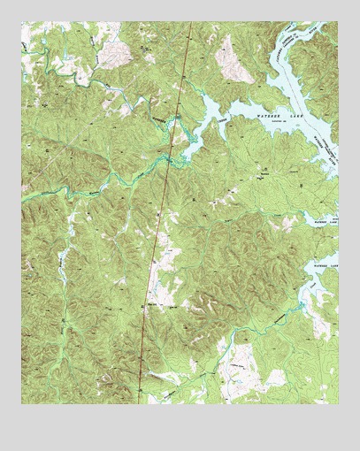
Flint Hill, SC USGS Topographic Map
Click on map above to begin viewing in our Map Viewer.

This topographic map contains these locations and features:
Feature Name Type Latitude Longitude GNIS ID View Map
Aldrichs Shoal (historical)RapidsN34.4918°W80.8970°1236981View Map
Biddle (historical)Populated PlaceN34.4649°W80.8909°1236990View Map
Big Wateree CreekStreamN34.4676°W80.8881°1220742View Map
BucklickPopulated PlaceN34.4513°W80.9034°1227871View Map
Camp WelfareLocaleN34.4901°W80.9512°1236995View Map
Catawba RiverStreamN34.4668°W80.8890°1010097View Map
Caughmans Duck Pond D-1572 DamDamN34.4835°W80.9981°1239022View Map
Crooked CreekStreamN34.4965°W80.8959°1221837View Map
Dukes Ford (historical)CrossingN34.4904°W80.8979°1237004View Map
Dutchman CreekPopulated PlaceN34.4232°W80.8848°1237005View Map
Flint HillPopulated PlaceN34.4076°W80.9509°1247780View Map
Hogfork BranchStreamN34.4810°W80.9715°1223217View Map
Horse BranchStreamN34.4440°W80.9759°1223305View Map
Interchange 41CrossingN34.4090°W80.9945°1228244View Map
Interchange 46CrossingN34.4724°W80.9968°1228245View Map
Little Wateree CreekStreamN34.4621°W80.9295°1224071View Map
Montgomerys Island (historical)IslandN34.4901°W80.8965°1241713View Map
Mount Zion CemeteryCemeteryN34.4732°W80.9895°1248805View Map
Mount Zion ChurchChurchN34.4732°W80.9901°1249721View Map
New Zion Church (historical)ChurchN34.4371°W80.9415°1237058View Map
New Zion School (historical)SchoolN34.4357°W80.9434°1237059View Map
Pickels Mill (historical)LocaleN34.4968°W80.8895°1237063View Map
Piney Grove School (historical)SchoolN34.3846°W80.9681°1237064View Map
Rock Hill ChurchChurchN34.4493°W80.9054°1225934View Map
Scabbler BranchStreamN34.4899°W80.9973°1226435View Map
Taylors CreekPopulated PlaceN34.4426°W80.8831°1237095View Map
White Oak ChurchChurchN34.4071°W80.9423°1227545View Map
White Oak School (historical)SchoolN34.4071°W80.9412°1237106View Map
Zion ChurchChurchN34.4910°W80.9512°1227757View Map

Note: Coordinates in the location and feature list above are referenced to NAD83 datum.


Copyright (C) 2008-2025 Ryan Niemi / Sunset Dynamics ... All Rights Reserved