TopoQuest Logo
Do you find TopoQuest useful?
Help keep TopoQuest running and adding new maps/features by donating!
Bitcoin:  19c7KJd3qBynnjoSw5npx9KScwjBe4ifkT
Litecoin:  LXs6TkuXGGXo1vDsWCkWVdjQX94eUKd6ui
Home View Maps Find Maps Find Places Resources & Links


Winthrop, Maine Topographic Map

USGS Map Title: Winthrop, ME
USGS Map MRC: 44069C8
DRG (GeoTIFF) Download: o44069c8.tif


Neighboring USGS Topographic Map Quads:


  Fayette, ME  
44070D1
 

  Readfield, ME  
44069D8
 

  Belgrade, ME  
44069D7
 

  Wayne, ME  
44070C1
 

  Winthrop, ME  
44069C8
 

  Augusta, ME  
44069C7
 

  Monmouth, ME  
44070B1
 

  Purgatory, ME  
44069B8
 

  Gardiner, ME  
44069B7


Map MRC Location:

N45°
W70°
N45°
W69°
H8 H7 H6 H5 H4 H3 H2 H1
G8 G7 G6 G5 G4 G3 G2 G1
F8 F7 F6 F5 F4 F3 F2 F1
E8 E7 E6 E5 E4 E3 E2 E1
D8 D7 D6 D5 D4 D3 D2 D1
C8 C7 C6 C5 C4 C3 C2 C1
B8 B7 B6 B5 B4 B3 B2 B1
A8 A7 A6 A5 A4 A3 A2 A1
N44°
W70°
N44°
W69°

Winthrop, ME USGS 1:24K Topographic Map Preview:
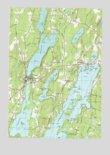
Winthrop, ME USGS Topographic Map
Click on map above to begin viewing in our Map Viewer.

This topographic map contains these locations and features:
Feature Name Type Latitude Longitude GNIS ID View Map
Annabessacook LakeLakeN44.2683°W69.9810°561266View Map
Barber CemeteryCemeteryN44.3531°W69.8839°561591View Map
Beaver BrookStreamN44.3520°W69.9364°561892View Map
Belle IslandIslandN44.2870°W69.9125°562024View Map
Benson Family CemeteryCemeteryN44.2702°W69.8835°2736355View Map
Big IslandIslandN44.2642°W69.9817°562187View Map
Black IslandIslandN44.2837°W69.9142°562445View Map
Bog BrookStreamN44.2665°W69.8903°562678View Map
Brainard PondLakeN44.3705°W69.9164°562880View Map
Carleton PondReservoirN44.3488°W69.9075°563569View Map
Carleton Pond DamDamN44.3417°W69.9162°1773685View Map
Charles M Bailey Public LibraryBuildingN44.3080°W69.9729°2738434View Map
Cobbosseecontee Lake DamDamN44.2798°W69.8894°1773681View Map
Crams PointCapeN44.2553°W69.9328°564453View Map
Cuba IslandIslandN44.2915°W69.8959°564639View Map
East Readfield CemeteryCemeteryN44.3626°W69.9108°2736705View Map
East WinthropPopulated PlaceN44.3217°W69.8964°565704View Map
East Winthrop CemeteryCemeteryN44.3209°W69.8957°2736707View Map
Fowler Seaplane BaseAirportN44.3073°W69.9423°582250View Map
Friends CemeteryCemeteryN44.2583°W69.9059°2736716View Map
Frog IslandIslandN44.2790°W69.9123°566603View Map
Hersey IslandIslandN44.3156°W69.8906°567978View Map
Hodgdon IslandIslandN44.2876°W69.9048°568138View Map
Horseshoe IslandIslandN44.2726°W69.9187°568306View Map
Howard CemeteryCemeteryN44.2579°W69.9072°2736730View Map
Hoyt BrookStreamN44.2812°W69.9809°568408View Map
Island ParkPopulated PlaceN44.3212°W69.8875°568691View Map
Kezar BrookStreamN44.2990°W69.9142°569139View Map
Kezar PondLakeN44.3157°W69.9166°569145View Map
Lakeside Marina Seaplane BaseAirportN44.3209°W69.8889°582249View Map
Lakeview CemeteryCemeteryN44.2924°W69.9318°569324View Map
Lily PondLakeN44.2667°W69.9089°569572View Map
Little Cobbosseecontee LakeLakeN44.3283°W69.8863°569737View Map
Lower Narrows PondLakeN44.2906°W69.9506°570523View Map
Lower Sister IslandIslandN44.2951°W69.9089°570545View Map
Maple CemeteryCemeteryN44.3047°W69.9737°2736740View Map
MaranacookPopulated PlaceN44.3470°W69.9581°579496View Map
Maranacook CampLocaleN44.3712°W69.9578°570755View Map
Maranacook LakeReservoirN44.3454°W69.9564°570756View Map
Maranacook Lake Upper DamDamN44.3097°W69.9723°1773687View Map
Mears BrookStreamN44.3306°W69.8820°571103View Map
Metcalf CemeteryCemeteryN44.3229°W69.9402°571192View Map
Mill PondReservoirN44.3720°W69.9236°571340View Map
Mill Pond DamDamN44.3706°W69.9270°1774370View Map
Molazigan IslandIslandN44.2826°W69.9012°571486View Map
Monks HillSummitN44.3600°W69.8829°571503View Map
Monmouth Neck CemeteryCemeteryN44.2602°W69.9492°2736745View Map
Packards LedgeBarN44.3126°W69.8920°572911View Map
Readfield Elementary SchoolSchoolN44.3726°W69.9400°2737916View Map
Richards IslandIslandN44.2506°W69.9334°574167View Map
Robbins PointCapeN44.2995°W69.9120°574292View Map
Shed PondLakeN44.3602°W69.8759°575334View Map
Sturtevant HillPopulated PlaceN44.3395°W69.9912°579750View Map
TallwoodPopulated PlaceN44.3434°W69.9551°579758View Map
Town of WinthropCivilN44.3116°W69.9616°582824View Map
Upper Narrows PondLakeN44.3071°W69.9427°577636View Map
Upper Sister IslandIslandN44.2998°W69.9045°577659View Map
Welch PointCapeN44.3167°W69.8962°577984View Map
West PointCapeN44.2756°W69.9328°578198View Map
Whittier CemeteryCemeteryN44.3544°W69.9408°578438View Map
Wilson StreamStreamN44.2565°W69.9939°578556View Map
WinthropPopulated PlaceN44.3051°W69.9770°578610View Map
Winthrop Ambulance ServiceBuildingN44.2991°W69.9821°2666770View Map
Winthrop Census Designated PlaceCensusN44.3130°W69.9649°2377970View Map
Winthrop CenterPopulated PlaceN44.3048°W69.9214°578611View Map
Winthrop Grade SchoolSchoolN44.3050°W69.9678°2737942View Map
Winthrop High SchoolSchoolN44.3004°W69.9849°2737943View Map
Winthrop Middle SchoolSchoolN44.3032°W69.9860°2737937View Map
Winthrop Police DepartmentBuildingN44.3063°W69.9697°2735909View Map
Winthrop Post OfficePost OfficeN44.3069°W69.9729°2768923View Map
Winthrop Volunteer Fire DepartmentBuildingN44.3057°W69.9758°2552911View Map
WWLA-TV (Lewiston)TowerN44.3376°W69.9937°582100View Map

Note: Coordinates in the location and feature list above are referenced to NAD83 datum.


Copyright (C) 2008-2024 Ryan Niemi / Sunset Dynamics ... All Rights Reserved