TopoQuest Logo
Do you find TopoQuest useful?
Help keep TopoQuest running and adding new maps/features by donating!
Bitcoin:  19c7KJd3qBynnjoSw5npx9KScwjBe4ifkT
Litecoin:  LXs6TkuXGGXo1vDsWCkWVdjQX94eUKd6ui
Home View Maps Find Maps Find Places Resources & Links


Wolfinger Butte, Oregon Topographic Map

USGS Map Title: Wolfinger Butte, OR
USGS Map MRC: 44119D2
DRG (GeoTIFF) Download: o44119d2.tif


Neighboring USGS Topographic Map Quads:


  Donaldson Creek, OR  
44119E3
 

  Belshaw Meadows, OR  
44119E2
 

  Johnson Saddle, OR  
44119E1
 

  Shop Gulch, OR  
44119D3
 

  Wolfinger Butte, OR  
44119D2
 

  Mount Vernon, OR  
44119D1
 

  Big Weasel Springs, OR  
44119C3
 

  McClellan Mountain, OR  
44119C2
 

  Fall Mountain, OR  
44119C1


Map MRC Location:

N45°
W120°
N45°
W119°
H8 H7 H6 H5 H4 H3 H2 H1
G8 G7 G6 G5 G4 G3 G2 G1
F8 F7 F6 F5 F4 F3 F2 F1
E8 E7 E6 E5 E4 E3 E2 E1
D8 D7 D6 D5 D4 D3 D2 D1
C8 C7 C6 C5 C4 C3 C2 C1
B8 B7 B6 B5 B4 B3 B2 B1
A8 A7 A6 A5 A4 A3 A2 A1
N44°
W120°
N44°
W119°

Wolfinger Butte, OR USGS 1:24K Topographic Map Preview:
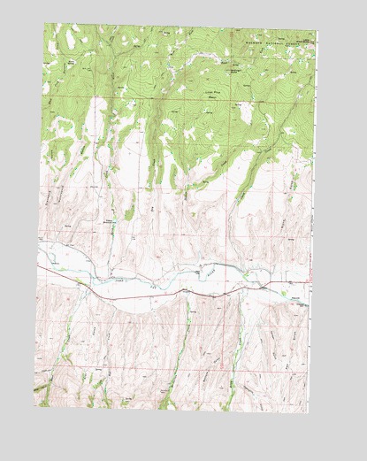
Wolfinger Butte, OR USGS Topographic Map
Click on map above to begin viewing in our Map Viewer.

This topographic map contains these locations and features:
Feature Name Type Latitude Longitude GNIS ID View Map
Barnard GulchValleyN44.3938°W119.1583°1137531View Map
Birch CreekStreamN44.4168°W119.2169°1138150View Map
Blue Mountain DitchCanalN44.4063°W119.2027°1152793View Map
Capsuttle CreekStreamN44.3840°W119.1586°1139363View Map
Clark CreekStreamN44.4232°W119.1564°1139753View Map
Damon CreekStreamN44.4199°W119.1766°1140609View Map
Dry CreekStreamN44.4163°W119.1900°1141280View Map
Dunlap CabinLocaleN44.4996°W119.1472°1156169View Map
East Fork Dry CreekStreamN44.4846°W119.1916°1141557View Map
First CreekStreamN44.3877°W119.2408°1142136View Map
Graveyard GulchValleyN44.4274°W119.2461°1142992View Map
Harper GulchValleyN44.4052°W119.1480°1143319View Map
Horse SpringSpringN44.4872°W119.2355°1143791View Map
Jenkins CabinLocaleN44.4777°W119.1327°1156168View Map
Lemons DitchCanalN44.4152°W119.1344°1153716View Map
Lemons RanchLocaleN44.4218°W119.1355°1167365View Map
Little Black ButteSummitN44.4957°W119.1286°1145099View Map
Lone Pine BasinBasinN44.4774°W119.1755°1145353View Map
McClellan CreekStreamN44.4171°W119.1886°1145934View Map
Moon CreekStreamN44.4149°W119.2244°1146415View Map
Moon Creek CemeteryCemeteryN44.4290°W119.2480°1146417View Map
Moon Creek School (historical)SchoolN44.4229°W119.2264°1167364View Map
Morse GulchValleyN44.4074°W119.2052°1152794View Map
Ran CreekStreamN44.4071°W119.2139°1148198View Map
Red GulchValleyN44.4102°W119.1275°1148297View Map
Riley CreekStreamN44.4177°W119.1550°1148451View Map
Second CreekStreamN44.3824°W119.2430°1149205View Map
Star GulchValleyN44.4107°W119.2275°1150344View Map
Stone GulchValleyN44.4213°W119.1422°1150446View Map
Waterspout GulchValleyN44.4265°W119.2405°1151959View Map
West Fork Dry CreekStreamN44.4843°W119.1911°1152071View Map
Wolfinger ButteSummitN44.4860°W119.1650°1152611View Map
Yokum ReservoirReservoirN44.4358°W119.2155°1152739View Map

Note: Coordinates in the location and feature list above are referenced to NAD83 datum.


Copyright (C) 2008-2024 Ryan Niemi / Sunset Dynamics ... All Rights Reserved