TopoQuest Logo
Do you find TopoQuest useful?
Help keep TopoQuest running and adding new maps/features by donating!
Bitcoin:  19c7KJd3qBynnjoSw5npx9KScwjBe4ifkT
Litecoin:  LXs6TkuXGGXo1vDsWCkWVdjQX94eUKd6ui
Home View Maps Find Maps Find Places Resources & Links


Woodburn North, Indiana Topographic Map

USGS Map Title: Woodburn North, IN
USGS Map MRC: 41084B7
DRG (GeoTIFF) Download: o41084b7.tif


Neighboring USGS Topographic Map Quads:


  Saint Joe, IN  
41084C8
 

  Hicksville, OH  
41084C7
 

  Mark Center, OH  
41084C6
 

  Grabill, IN  
41084B8
 

  Woodburn North, IN  
41084B7
 

  Antwerp, OH  
41084B6
 

  Maples, IN  
41084A8
 

  Woodburn South, IN  
41084A7
 

  Payne, OH  
41084A6


Map MRC Location:

N42°
W85°
N42°
W84°
H8 H7 H6 H5 H4 H3 H2 H1
G8 G7 G6 G5 G4 G3 G2 G1
F8 F7 F6 F5 F4 F3 F2 F1
E8 E7 E6 E5 E4 E3 E2 E1
D8 D7 D6 D5 D4 D3 D2 D1
C8 C7 C6 C5 C4 C3 C2 C1
B8 B7 B6 B5 B4 B3 B2 B1
A8 A7 A6 A5 A4 A3 A2 A1
N41°
W85°
N41°
W84°

Woodburn North, IN USGS 1:24K Topographic Map Preview:
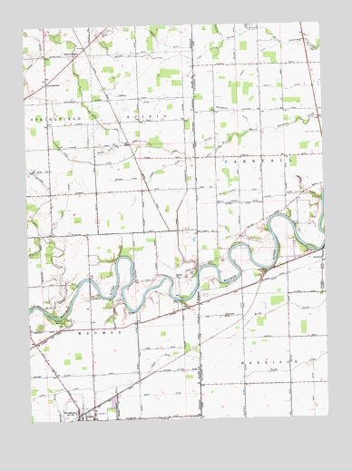
Woodburn North, IN USGS Topographic Map
Click on map above to begin viewing in our Map Viewer.

This topographic map contains these locations and features:
Feature Name Type Latitude Longitude GNIS ID View Map
Banks CemeteryCemeteryN41.1856°W84.7616°1048308View Map
Beerbower DitchCanalN41.2214°W84.7861°1037813View Map
Bethel ChurchChurchN41.1698°W84.8119°430948View Map
Black CreekStreamN41.1581°W84.8627°431130View Map
BluecastPopulated PlaceN41.1542°W84.8694°446650View Map
Bluecast SpringSpringN41.1565°W84.8604°431256View Map
Brenneke AirportAirportN41.1448°W84.8667°2676945View Map
Burrier DitchCanalN41.2014°W84.8322°431866View Map
Champion School (historical)SchoolN41.2081°W84.7852°1053351View Map
Chaney DitchCanalN41.1953°W84.7686°1038983View Map
Clark CemeteryCemeteryN41.2412°W84.7513°1048320View Map
Diehl CemeteryCemeteryN41.1723°W84.8050°433542View Map
Driver DitchCanalN41.2106°W84.8400°433696View Map
Enz DitchCanalN41.1250°W84.7825°1039917View Map
Ferrarre DitchCanalN41.1575°W84.7861°1040426View Map
GeorgetownPopulated PlaceN41.2320°W84.8655°435025View Map
Halls CornersPopulated PlaceN41.2409°W84.8522°435622View Map
Hamm DitchCanalN41.2334°W84.8516°435655View Map
Hamm Interceptor DitchCanalN41.2073°W84.8075°435656View Map
Hetrick DitchCanalN41.1275°W84.8627°436078View Map
Hook School (historical)SchoolN41.2370°W84.7850°1053350View Map
Imbach DitchCanalN41.1448°W84.8208°436712View Map
Jackson DitchCanalN41.2264°W84.8252°436888View Map
Jackson Number Two DitchCanalN41.2492°W84.8452°436894View Map
Jarrett Wood SubdivisionPopulated PlaceN41.1778°W84.7602°1961018View Map
Johnson DitchCanalN41.1698°W84.7513°1042124View Map
Killian DitchCanalN41.1934°W84.8580°437297View Map
Knapp DitchCanalN41.2039°W84.8194°437384View Map
Lichtys ParcelsPopulated PlaceN41.1778°W84.7630°1961024View Map
Link (historical)Populated PlaceN41.2373°W84.7952°1074241View Map
Link Post Office (historical)Post OfficeN41.2376°W84.7958°2042135View Map
Lucas DitchCanalN41.2417°W84.7966°1042821View Map
New Harrison (historical)Populated PlaceN41.1667°W84.8008°1961035View Map
Nindeville (historical)Populated PlaceN41.1359°W84.7852°1961038View Map
North Chaney DitchCanalN41.1973°W84.7847°1043931View Map
Penn DitchCanalN41.1264°W84.7563°1057918View Map
Purdy DitchCanalN41.2092°W84.7950°1044800View Map
School Number 1 (historical)SchoolN41.1714°W84.7763°1053353View Map
School Number 2 (historical)SchoolN41.1506°W84.7847°1053354View Map
School Number 5 (historical)SchoolN41.1875°W84.7752°1053352View Map
Scipio CemeteryCemeteryN41.2491°W84.8389°443127View Map
Scipio ChurchChurchN41.2481°W84.8411°443128View Map
Short DitchCanalN41.1331°W84.8180°443451View Map
Sieberi DitchCanalN41.1970°W84.7586°1046260View Map
South Chaney DitchCanalN41.1937°W84.7850°1046455View Map
Sowers DitchCanalN41.2442°W84.8152°443901View Map
Township of MaumeeCivilN41.1405°W84.8455°453616View Map
Township of ScipioCivilN41.2280°W84.8249°453834View Map
Tustison CreekStreamN41.2445°W84.7897°1047233View Map
Viland DitchCanalN41.1450°W84.8075°445290View Map
Wann DitchCanalN41.2145°W84.8633°445458View Map
Werling DitchCanalN41.1259°W84.8166°445680View Map
WoodburnPopulated PlaceN41.1253°W84.8533°446280View Map
Woodburn Volunteer Fire DepartmentBuildingN41.1256°W84.8488°2625752View Map
Zijlstra DairyLocaleN41.1453°W84.7681°2634673View Map
Zuber DitchCanalN41.2387°W84.7769°1048295View Map

Note: Coordinates in the location and feature list above are referenced to NAD83 datum.


Copyright (C) 2008-2025 Ryan Niemi / Sunset Dynamics ... All Rights Reserved