TopoQuest Logo
Do you find TopoQuest useful?
Help keep TopoQuest running and adding new maps/features by donating!
Bitcoin:  19c7KJd3qBynnjoSw5npx9KScwjBe4ifkT
Litecoin:  LXs6TkuXGGXo1vDsWCkWVdjQX94eUKd6ui
Home View Maps Find Maps Find Places Resources & Links


Maples, Indiana Topographic Map

USGS Map Title: Maples, IN
USGS Map MRC: 41084A8
DRG (GeoTIFF) Download: o41084a8.tif


Neighboring USGS Topographic Map Quads:


  Cedarville, IN  
41085B1
 

  Grabill, IN  
41084B8
 

  Woodburn North, IN  
41084B7
 

  Fort Wayne East, IN  
41085A1
 

  Maples, IN  
41084A8
 

  Woodburn South, IN  
41084A7
 

  Poe, IN  
40085H1
 

  Hoagland, IN  
40084H8
 

  Dixon, IN  
40084H7


Map MRC Location:

N42°
W85°
N42°
W84°
H8 H7 H6 H5 H4 H3 H2 H1
G8 G7 G6 G5 G4 G3 G2 G1
F8 F7 F6 F5 F4 F3 F2 F1
E8 E7 E6 E5 E4 E3 E2 E1
D8 D7 D6 D5 D4 D3 D2 D1
C8 C7 C6 C5 C4 C3 C2 C1
B8 B7 B6 B5 B4 B3 B2 B1
A8 A7 A6 A5 A4 A3 A2 A1
N41°
W85°
N41°
W84°

Maples, IN USGS 1:24K Topographic Map Preview:
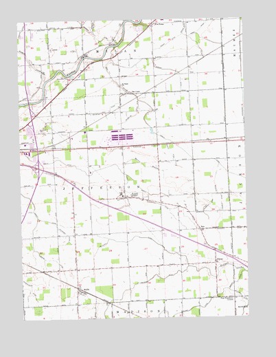
Maples, IN USGS Topographic Map
Click on map above to begin viewing in our Map Viewer.

This topographic map contains these locations and features:
Feature Name Type Latitude Longitude GNIS ID View Map
Air Park FieldAirportN41.1250°W84.9414°449399View Map
Bandelier DitchCanalN41.0862°W84.9511°430469View Map
Bandelier Ditch Number TwoCanalN41.0850°W84.9380°430470View Map
Bonjour DitchCanalN41.0553°W84.9708°431320View Map
Casad Industrial Park AirportAirportN41.0779°W84.9423°449286View Map
Converset DitchCanalN41.0359°W84.9758°432908View Map
Dennis DitchCanalN41.0273°W84.9902°433473View Map
Ellison DitchCanalN41.0025°W84.9219°434110View Map
Emmanuel CemeteryCemeteryN41.0787°W84.9869°434171View Map
Five PointsPopulated PlaceN41.1234°W84.9402°434546View Map
Gar CreekStreamN41.1142°W84.9461°434941View Map
Gromeaux DitchCanalN41.0471°W84.8957°2612630View Map
Grover DitchCanalN41.1081°W84.9514°435535View Map
Henry Bandelier DitchCanalN41.0717°W84.9850°436027View Map
Huguenard DitchCanalN41.0722°W84.9275°2612629View Map
Klines Airport (historical)AirportN41.0317°W84.9630°449285View Map
MaplesPopulated PlaceN41.0128°W84.9691°438581View Map
Martin BranchStreamN41.0625°W84.9444°438661View Map
Martin DitchCanalN41.0637°W84.9522°438671View Map
McHenry DitchCanalN41.0342°W84.9375°438881View Map
Meier DitchCanalN41.1123°W84.9730°438969View Map
Nahrwold DitchCanalN41.1181°W84.9452°439927View Map
New Haven Conservation ClubLocaleN41.1012°W84.9716°452370View Map
Peoples ChapelChurchN41.0803°W84.9508°441009View Map
Popitz DitchCanalN41.1223°W84.9764°441439View Map
Reichhart Airport (historical)AirportN41.0287°W84.9972°2676867View Map
Rorick DitchCanalN41.0698°W84.9475°442287View Map
Rushart DitchCanalN41.1042°W84.9430°442408View Map
Ryan DitchCanalN41.0503°W84.9414°442432View Map
Saint Louis SchoolSchoolN41.0509°W84.9389°442660View Map
Saint Pauls ChurchChurchN41.0984°W84.9433°442785View Map
Schaaf DitchCanalN41.1156°W84.9427°443062View Map
Schumacher DitchCanalN41.1000°W84.8764°443121View Map
Sharpenburg DitchCanalN41.0137°W84.9947°443312View Map
Sixmile CreekStreamN41.0998°W84.9855°443568View Map
Spindler DitchCanalN41.1231°W84.9580°443951View Map
Summers DitchCanalN41.1234°W84.9644°444388View Map
TillmanPopulated PlaceN41.0242°W84.8933°444761View Map
Township of JeffersonCivilN41.0500°W84.9423°453478View Map
Yoquelet DitchCanalN41.0469°W84.8888°2612631View Map
ZuluPopulated PlaceN41.0370°W84.8922°446497View Map

Note: Coordinates in the location and feature list above are referenced to NAD83 datum.


Copyright (C) 2008-2024 Ryan Niemi / Sunset Dynamics ... All Rights Reserved